TopoQuest Logo
Do you find TopoQuest useful?
Help keep TopoQuest running and adding new maps/features by donating!
Bitcoin:  19c7KJd3qBynnjoSw5npx9KScwjBe4ifkT
Litecoin:  LXs6TkuXGGXo1vDsWCkWVdjQX94eUKd6ui
Home View Maps Find Maps Find Places Resources & Links


L'Anse, Michigan Topographic Map

USGS Map Title: L'Anse, MI
USGS Map MRC: 46088G4
DRG (GeoTIFF) Download: o46088g4.tif


Neighboring USGS Topographic Map Quads:


  Otter Lake, MI  
46088H5
 

  Portage Entry, MI  
46088H4
 

  Keweenaw Bay NE, MI  
46088H3
 

  Bear Town, MI  
46088G5
 

  L'Anse, MI  
46088G4
 

  Aura, MI  
46088G3
 

  Baraga Plains, MI  
46088F5
 

  Alberta, MI  
46088F4
 

  Herman, MI  
46088F3


Map MRC Location:

N47°
W89°
N47°
W88°
H8 H7 H6 H5 H4 H3 H2 H1
G8 G7 G6 G5 G4 G3 G2 G1
F8 F7 F6 F5 F4 F3 F2 F1
E8 E7 E6 E5 E4 E3 E2 E1
D8 D7 D6 D5 D4 D3 D2 D1
C8 C7 C6 C5 C4 C3 C2 C1
B8 B7 B6 B5 B4 B3 B2 B1
A8 A7 A6 A5 A4 A3 A2 A1
N46°
W89°
N46°
W88°

L'Anse, MI USGS 1:24K Topographic Map Preview:
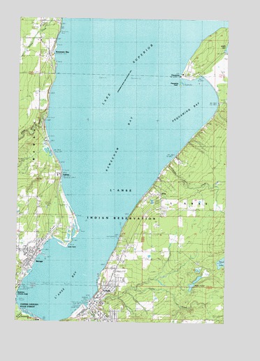
L'Anse, MI USGS Topographic Map
Click on map above to begin viewing in our Map Viewer.

This topographic map contains these locations and features:
Feature Name Type Latitude Longitude GNIS ID View Map
AssininsPopulated PlaceN46.8102°W88.4774°620286View Map
Assinins CemeteryCemeteryN46.8153°W88.4761°2129380View Map
Assinins Post Office (historical)Post OfficeN46.8103°W88.4750°2129320View Map
Assinins Station (historical)LocaleN46.8111°W88.4736°2129319View Map
BaragaPopulated PlaceN46.7785°W88.4890°620570View Map
Baraga Area High SchoolSchoolN46.7772°W88.4950°2129367View Map
Baraga County CourthouseBuildingN46.7578°W88.4533°2129144View Map
Baraga County Family PracticeHospitalN46.7647°W88.4450°2129156View Map
Baraga County Historical MuseumBuildingN46.7719°W88.4906°2129363View Map
Baraga Full Gospel ChurchChurchN46.7783°W88.4892°2129354View Map
Baraga MarinaLocaleN46.7780°W88.4865°1618752View Map
Baraga Police DepartmentBuildingN46.7878°W88.4819°2129361View Map
Baraga Post OfficePost OfficeN46.7850°W88.4806°2129357View Map
Baraga StationLocaleN46.7783°W88.4881°2129355View Map
Baraga Village CemeteryCemeteryN46.7893°W88.4740°2129379View Map
Baraga Volunteer Fire DepartmentBuildingN46.7879°W88.4820°2129360View Map
Bay AmbulanceBuildingN46.7792°W88.4929°2661904View Map
Bayview Family PracticeHospitalN46.7631°W88.4481°2129146View Map
Bethel United Pentecostal ChurchChurchN46.7622°W88.4481°2129147View Map
Blessed Kateri ChurchChurchN46.7567°W88.4528°2129152View Map
Falls RiverStreamN46.7569°W88.4571°625816View Map
Holy Cross ChurchChurchN46.7789°W88.4919°2129348View Map
Keeweenaw Bay Tribal Police DepartmentBuildingN46.7974°W88.4736°2737631View Map
Keweenaw BayBayN46.8660°W88.4218°629641View Map
Keweenaw BayPopulated PlaceN46.8602°W88.4818°629642View Map
Keweenaw Bay Fire DepartmentBuildingN46.8639°W88.4849°2626799View Map
Keweenaw Bay Post Office (historical)Post OfficeN46.8603°W88.4817°2129289View Map
Keweenaw Bay Tribal CenterLocaleN46.8102°W88.4757°1618750View Map
Keweenaw Station (historical)LocaleN46.8606°W88.4800°2129288View Map
L'AnsePopulated PlaceN46.7566°W88.4529°629897View Map
L'Anse Baptist ChurchChurchN46.7708°W88.4414°2129150View Map
L'Anse BayBayN46.7674°W88.4687°629898View Map
L'Anse Fire DepartmentBuildingN46.7581°W88.4535°2626739View Map
L'Anse Police DepartmentBuildingN46.7581°W88.4535°2129143View Map
L'Anse Post OfficePost OfficeN46.7590°W88.4532°2129153View Map
L'Anse Public LibraryBuildingN46.7578°W88.4481°2129154View Map
L'Anse ReservationCivilN46.7811°W88.4022°1616978View Map
L'Anse Township High SchoolSchoolN46.7578°W88.4481°2129158View Map
L'Anse Township ParkParkN46.7858°W88.4378°2129330View Map
L'Anse Township Park CampgroundLocaleN46.7858°W88.4378°2129331View Map
Linden CreekStreamN46.7591°W88.4551°630497View Map
Little Carp RiverStreamN46.8349°W88.4821°630586View Map
Little Silver CreekStreamN46.8144°W88.4115°630766View Map
Michigan Department of Natural Resources Baraga ForestBuildingN46.7874°W88.4759°2626798View Map
Ojibwa CampgroundLocaleN46.7892°W88.4711°2129159View Map
Ojibwa Community CollegeSchoolN46.7783°W88.4900°2129359View Map
PequamingPopulated PlaceN46.8519°W88.4004°634613View Map
Pequaming BayBayN46.8388°W88.4018°634614View Map
Pequaming CemeteryCemeteryN46.8531°W88.3944°2129375View Map
Pequaming PointCapeN46.8491°W88.4032°634615View Map
Pequaming Post Office (historical)Post OfficeN46.8519°W88.4003°2129281View Map
Pinery Indian CemeteryCemeteryN46.7721°W88.3839°2129374View Map
Pinery LakesLakeN46.7750°W88.3763°635006View Map
Sacred Heart ChurchChurchN46.7542°W88.4503°2129151View Map
Sacret Heart SchoolSchoolN46.7528°W88.4501°2129157View Map
Saint Ann's ChurchChurchN46.7792°W88.4936°2129351View Map
Sand PointCapeN46.7816°W88.4710°637202View Map
Sand Point LightLocaleN46.7849°W88.4662°1618751View Map
Sixmile CreekStreamN46.7535°W88.4957°1617396View Map
Solid Rock Baptist ChurchChurchN46.7817°W88.4833°2129353View Map
Third LakeLakeN46.7750°W88.3763°1618209View Map
United Lutheran ChurchChurchN46.7617°W88.4489°2129148View Map
United Methodist ChurchChurchN46.7608°W88.4506°2129149View Map
Victory Christian AssemblyChurchN46.7767°W88.4919°2129350View Map
Village of BaragaCivilN46.7769°W88.4959°2398031View Map
Village of L'AnseCivilN46.7525°W88.4476°2398394View Map
WDXW-AM (L'Anse)TowerN46.7924°W88.4862°1625256View Map
ZebaPopulated PlaceN46.8024°W88.4146°1616916View Map
Zeba Census Designated PlaceCensusN46.7927°W88.4133°2628828View Map
Zeba Indian United Methodist Church Historical MarkerParkN46.8025°W88.4147°2129383View Map
Zeba Post Office (historical)Post OfficeN46.8025°W88.4144°2129275View Map

Note: Coordinates in the location and feature list above are referenced to NAD83 datum.


Copyright (C) 2008-2024 Ryan Niemi / Sunset Dynamics ... All Rights Reserved