TopoQuest Logo
Do you find TopoQuest useful?
Help keep TopoQuest running and adding new maps/features by donating!
Bitcoin:  19c7KJd3qBynnjoSw5npx9KScwjBe4ifkT
Litecoin:  LXs6TkuXGGXo1vDsWCkWVdjQX94eUKd6ui
Home View Maps Find Maps Find Places Resources & Links


La Cygne, Kansas Topographic Map

USGS Map Title: La Cygne, KS
USGS Map MRC: 38094C7
DRG (GeoTIFF) Download: o38094c7.tif


Neighboring USGS Topographic Map Quads:


  Osawatomie, KS  
38094D8
 

  Fontana, KS  
38094D7
 

  New Lancaster, KS  
38094D6
 

  Parker, KS  
38094C8
 

  La Cygne, KS  
38094C7
 

  Boicourt, KS  
38094C6
 

  Mound City NW, KS  
38094B8
 

  Mound City, KS  
38094B7
 

  Pleasanton, KS  
38094B6


Map MRC Location:

N39°
W95°
N39°
W94°
H8 H7 H6 H5 H4 H3 H2 H1
G8 G7 G6 G5 G4 G3 G2 G1
F8 F7 F6 F5 F4 F3 F2 F1
E8 E7 E6 E5 E4 E3 E2 E1
D8 D7 D6 D5 D4 D3 D2 D1
C8 C7 C6 C5 C4 C3 C2 C1
B8 B7 B6 B5 B4 B3 B2 B1
A8 A7 A6 A5 A4 A3 A2 A1
N38°
W95°
N38°
W94°

La Cygne, KS USGS 1:24K Topographic Map Preview:
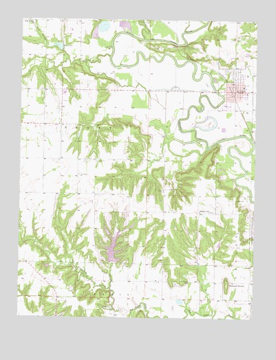
La Cygne, KS USGS Topographic Map
Click on map above to begin viewing in our Map Viewer.

This topographic map contains these locations and features:
Feature Name Type Latitude Longitude GNIS ID View Map
Beachner Grain Elevator Number 24LocaleN38.3439°W94.7620°2695330View Map
Brooklyn CemeteryCemeteryN38.3040°W94.7972°477687View Map
Brooklyn SchoolSchoolN38.2947°W94.7794°477686View Map
Calvary Baptist ChurchChurchN38.3486°W94.7619°2689727View Map
City of La CygneCivilN38.3473°W94.7602°2395564View Map
Elm CreekStreamN38.3592°W94.8277°477695View Map
Emergystat Ambulance of Linn CountyBuildingN38.3491°W94.7631°2754320View Map
Graveyard MoundSummitN38.2647°W94.7644°477701View Map
Hickory CreekStreamN38.2761°W94.7886°477458View Map
Hurley FieldParkN38.3464°W94.7541°477690View Map
La CygnePopulated PlaceN38.3500°W94.7613°477688View Map
La Cygne Christian ChurchChurchN38.3489°W94.7627°2689728View Map
La Cygne City HallBuildingN38.3462°W94.7627°2693013View Map
La Cygne Community BuildingBuildingN38.3461°W94.7627°2692577View Map
La Cygne Elementary SchoolSchoolN38.3467°W94.7561°2437525View Map
La Cygne Fire DepartmentBuildingN38.3456°W94.7661°2111499View Map
La Cygne Historical Society MuseumBuildingN38.3475°W94.7627°2694896View Map
La Cygne Police DepartmentBuildingN38.3465°W94.7630°2504050View Map
La Cygne Senior CenterBuildingN38.3460°W94.7615°2692578View Map
La Cygne Sewer Treatment PlantLocaleN38.3283°W94.7674°2691898View Map
La Cygne United Methodist ChurchChurchN38.3476°W94.7610°2689463View Map
La Cygne Water Treatment PlantLocaleN38.3460°W94.7674°2693484View Map
Lacygne Industrial ParkLocaleN38.3385°W94.7559°2692177View Map
Linn County Library District Number 2BuildingN38.3468°W94.7620°2694744View Map
Middle CreekStreamN38.3667°W94.8102°477636View Map
Oak Grove School (historical)SchoolN38.2653°W94.7847°477700View Map
Oaklawn CemeteryCemeteryN38.3504°W94.7686°477689View Map
Our Lady of the Lourdes Catholic ChurchChurchN38.3548°W94.7595°2689729View Map
Prairie Home CemeteryCemeteryN38.3095°W94.8437°477684View Map
Prairie Home SchoolSchoolN38.3034°W94.8450°477685View Map
Prairie View High SchoolSchoolN38.3441°W94.8519°2437526View Map
Prairie View High School Police United School District 362BuildingN38.3442°W94.8521°2504279View Map
Prairie View Middle SchoolSchoolN38.3426°W94.8525°2437527View Map
Richland CemeteryCemeteryN38.2541°W94.8255°477693View Map
Richland CreekStreamN38.2514°W94.8150°477698View Map
Riverview CemeteryCemeteryN38.2997°W94.7608°477694View Map
Stave LakeReservoirN38.3628°W94.8536°477691View Map
Tanglewood Lakes Wastewater Treatment PlantLocaleN38.2648°W94.8324°2692150View Map
Township of ScottCivilN38.3309°W94.8452°477637View Map
Turkey CreekStreamN38.2625°W94.8264°477699View Map
Twin Springs ChurchChurchN38.3747°W94.8708°477692View Map
Twin Springs CreekStreamN38.3584°W94.8508°477696View Map

Note: Coordinates in the location and feature list above are referenced to NAD83 datum.


Copyright (C) 2008-2025 Ryan Niemi / Sunset Dynamics ... All Rights Reserved