TopoQuest Logo
Do you find TopoQuest useful?
Help keep TopoQuest running and adding new maps/features by donating!
Bitcoin:  19c7KJd3qBynnjoSw5npx9KScwjBe4ifkT
Litecoin:  LXs6TkuXGGXo1vDsWCkWVdjQX94eUKd6ui
Home View Maps Find Maps Find Places Resources & Links


Bedford, Kentucky Topographic Map

USGS Map Title: Bedford, KY
USGS Map MRC: 38085E3
DRG (GeoTIFF) Download: o38085e3.tif


Neighboring USGS Topographic Map Quads:


  Madison West, IN  
38085F4
 

  Madison East, IN  
38085F3
 

  Carrollton, KY  
38085F2
 

  Bethlehem, IN  
38085E4
 

  Bedford, KY  
38085E3
 

  Campbellsburg, KY  
38085E2
 

  La Grange, KY  
38085D4
 

  Smithfield, KY  
38085D3
 

  New Castle, KY  
38085D2


Map MRC Location:

N39°
W86°
N39°
W85°
H8 H7 H6 H5 H4 H3 H2 H1
G8 G7 G6 G5 G4 G3 G2 G1
F8 F7 F6 F5 F4 F3 F2 F1
E8 E7 E6 E5 E4 E3 E2 E1
D8 D7 D6 D5 D4 D3 D2 D1
C8 C7 C6 C5 C4 C3 C2 C1
B8 B7 B6 B5 B4 B3 B2 B1
A8 A7 A6 A5 A4 A3 A2 A1
N38°
W86°
N38°
W85°

Bedford, KY USGS 1:24K Topographic Map Preview:
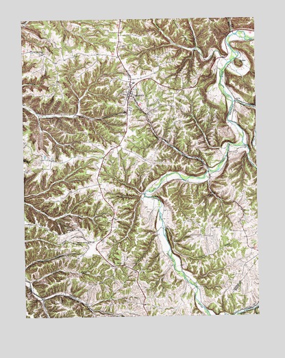
Bedford, KY USGS Topographic Map
Click on map above to begin viewing in our Map Viewer.

This topographic map contains these locations and features:
Feature Name Type Latitude Longitude GNIS ID View Map
Antioch ChurchChurchN38.5509°W85.2736°485999View Map
Barebone (historical)Populated PlaceN38.5842°W85.3406°2742515View Map
BedfordPopulated PlaceN38.5926°W85.3177°486653View Map
Bedford DivisionCivilN38.5785°W85.3185°1936871View Map
Bedford Fire Department and Ambulance ServiceBuildingN38.5933°W85.3165°2636753View Map
Bedford Springs and Hotel Historical MarkerParkN38.5829°W85.3201°2744789View Map
Bedford Volunteer Fire and RescueBuildingN38.5329°W85.3347°2637224View Map
Bunker HillSummitN38.6059°W85.2594°488394View Map
Burroughs (historical)Populated PlaceN38.5493°W85.3042°2742516View Map
Burrows CemeteryCemeteryN38.5222°W85.3244°2678834View Map
CarmonPopulated PlaceN38.5706°W85.2555°2742517View Map
Carmon CreekStreamN38.5717°W85.2569°488944View Map
City of BedfordCivilN38.5957°W85.3176°2403834View Map
Daugherty CreekStreamN38.5898°W85.2622°490608View Map
Demeree BranchStreamN38.5381°W85.3008°490804View Map
Dry ForkStreamN38.6126°W85.2813°491207View Map
Estes CemeteryCemeteryN38.5319°W85.2850°2728740View Map
Foree Cemetery Number 2CemeteryN38.5103°W85.2672°2728761View Map
Gill RidgePopulated PlaceN38.5671°W85.3323°2742521View Map
Hardy CreekStreamN38.6062°W85.2644°493737View Map
Hickory Grove (historical)Populated PlaceN38.5316°W85.3397°2742522View Map
Hickory Grove ChurchChurchN38.5315°W85.3400°494130View Map
Middle Fork Blue RiverStreamN38.5481°W85.2538°439094View Map
Millers BranchStreamN38.6181°W85.2613°498357View Map
Morton RidgeRidgeN38.5367°W85.3625°498644View Map
Organ CreekStreamN38.5076°W85.3655°499994View Map
Poplar Ridge (historical)Populated PlaceN38.6092°W85.3636°2742528View Map
Poplar Ridge ChurchChurchN38.6106°W85.3638°501129View Map
Pruiett CemeteryCemeteryN38.5272°W85.2858°2729069View Map
Science HollowValleyN38.5702°W85.2690°503073View Map
Staten-Garriott CemeteryCemeteryN38.5325°W85.2639°2729090View Map
Sweetwater BranchStreamN38.5151°W85.3727°504853View Map
Town BranchStreamN38.5606°W85.2747°505382View Map
Trimble CountyCivilN38.6130°W85.3376°516958View Map
Trimble County Historical MarkerParkN38.5932°W85.3176°2744786View Map
Trimble County Jail Historical MarkerParkN38.5935°W85.3176°2744788View Map
Trimble County Sheriff's OfficeBuildingN38.5933°W85.3177°2767446View Map
Upper Middle CreekPopulated PlaceN38.5468°W85.3297°2742534View Map

Note: Coordinates in the location and feature list above are referenced to NAD83 datum.


Copyright (C) 2008-2025 Ryan Niemi / Sunset Dynamics ... All Rights Reserved