TopoQuest Logo
Do you find TopoQuest useful?
Help keep TopoQuest running and adding new maps/features by donating!
Bitcoin:  19c7KJd3qBynnjoSw5npx9KScwjBe4ifkT
Litecoin:  LXs6TkuXGGXo1vDsWCkWVdjQX94eUKd6ui
Home View Maps Find Maps Find Places Resources & Links


La Pine, Oregon Topographic Map

USGS Map Title: La Pine, OR
USGS Map MRC: 43121F5
DRG (GeoTIFF) Download: o43121f5.tif


Neighboring USGS Topographic Map Quads:


  Round Mountain, OR  
43121G6
 

  Pistol Butte, OR  
43121G5
 

  Anns Butte, OR  
43121G4
 

  Wickiup Dam, OR  
43121F6
 

  La Pine, OR  
43121F5
 

  Finley Butte, OR  
43121F4
 

  Cryder Butte, OR  
43121E6
 

  Masten Butte, OR  
43121E5
 

  Moffitt Butte, OR  
43121E4


Map MRC Location:

N44°
W122°
N44°
W121°
H8 H7 H6 H5 H4 H3 H2 H1
G8 G7 G6 G5 G4 G3 G2 G1
F8 F7 F6 F5 F4 F3 F2 F1
E8 E7 E6 E5 E4 E3 E2 E1
D8 D7 D6 D5 D4 D3 D2 D1
C8 C7 C6 C5 C4 C3 C2 C1
B8 B7 B6 B5 B4 B3 B2 B1
A8 A7 A6 A5 A4 A3 A2 A1
N43°
W122°
N43°
W121°

La Pine, OR USGS 1:24K Topographic Map Preview:
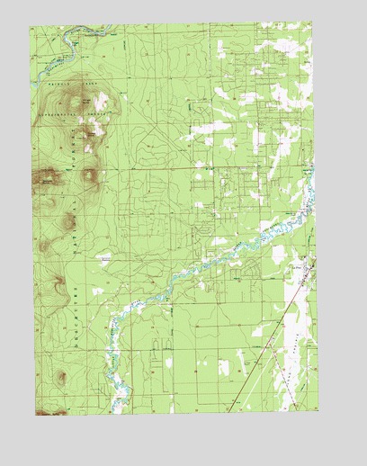
La Pine, OR USGS Topographic Map
Click on map above to begin viewing in our Map Viewer.

This topographic map contains these locations and features:
Feature Name Type Latitude Longitude GNIS ID View Map
Carey Stearns RanchLocaleN43.6885°W121.5095°1139372View Map
Cruiser ButteSummitN43.7145°W121.6020°1140498View Map
Department of Motor Vehicles La PineBuildingN43.6713°W121.5057°2699296View Map
Deschutes County Justice Court La PineBuildingN43.6651°W121.5073°2699029View Map
Deschutes County Sheriff's Office La Pine SubstationBuildingN43.6651°W121.5071°2737670View Map
Dorrance MeadowFlatN43.6746°W121.5945°1158214View Map
La PinePopulated PlaceN43.6704°W121.5036°1144724View Map
La Pine City HallBuildingN43.6651°W121.5073°2699050View Map
La Pine Elementary SchoolSchoolN43.6758°W121.5065°1161760View Map
La Pine Fire Department Station 103BuildingN43.7036°W121.5267°2576926View Map
La Pine Middle SchoolSchoolN43.6763°W121.5083°2417015View Map
La Pine Post OfficePost OfficeN43.6762°W121.5047°1165501View Map
La Pine Public LibraryBuildingN43.6743°W121.5049°2699051View Map
La Pine RodeoLocaleN43.6738°W121.5122°2699527View Map
La Pine Rural Fire Protection DistrictBuildingN43.6733°W121.5043°2576924View Map
La Pine Senior High SchoolSchoolN43.6795°W121.5070°2417014View Map
Long Prairie SloughStreamN43.6832°W121.5117°1116613View Map
Masten CemeteryCemeteryN43.6359°W121.5872°1153035View Map
Oregon Outback Rural Fire Protection DistrictBuildingN43.6651°W121.5072°2577062View Map
Pringle ButteSummitN43.7254°W121.6037°1148004View Map
Pringle FallsFallsN43.7432°W121.6084°1148006View Map
Pringle Falls Experimental StationLocaleN43.7393°W121.6117°1163764View Map
Pringle Falls Recreation SiteLocaleN43.7478°W121.6023°1148007View Map
Pringlefalls Post Office (historical)Post OfficeN43.7415°W121.6070°1164618View Map
Rosland CampgroundLocaleN43.7026°W121.5053°1156497View Map
Rosland Post Office (historical)Post OfficeN43.6887°W121.5053°1165885View Map
Springer RanchLocaleN43.6343°W121.5167°1167068View Map
Wampus ButteSummitN43.6997°W121.6217°1151872View Map
Wyeth Boat LaunchLocaleN43.7378°W121.6160°2700229View Map
Wyeth Recreation SiteLocaleN43.7379°W121.6161°1148490View Map

Note: Coordinates in the location and feature list above are referenced to NAD83 datum.


Copyright (C) 2008-2024 Ryan Niemi / Sunset Dynamics ... All Rights Reserved