TopoQuest Logo
Do you find TopoQuest useful?
Help keep TopoQuest running and adding new maps/features by donating!
Bitcoin:  19c7KJd3qBynnjoSw5npx9KScwjBe4ifkT
Litecoin:  LXs6TkuXGGXo1vDsWCkWVdjQX94eUKd6ui
Home View Maps Find Maps Find Places Resources & Links


La Ventana, New Mexico Topographic Map

USGS Map Title: La Ventana, NM
USGS Map MRC: 35106G8
DRG (GeoTIFF) Download: o35106g8.tif


Neighboring USGS Topographic Map Quads:


  Mesa Portales, NM  
35107H1
 

  San Pablo, NM  
35106H8
 

  Rancho del Chaparral, NM  
35106H7
 

  Headcut Reservoir, NM  
35107G1
 

  La Ventana, NM  
35106G8
 

  San Miguel Mountain, NM  
35106G7
 

  San Luis, NM  
35107F1
 

  Holy Ghost Spring, NM  
35106F8
 

  Gilman, NM  
35106F7


Map MRC Location:

N36°
W107°
N36°
W106°
H8 H7 H6 H5 H4 H3 H2 H1
G8 G7 G6 G5 G4 G3 G2 G1
F8 F7 F6 F5 F4 F3 F2 F1
E8 E7 E6 E5 E4 E3 E2 E1
D8 D7 D6 D5 D4 D3 D2 D1
C8 C7 C6 C5 C4 C3 C2 C1
B8 B7 B6 B5 B4 B3 B2 B1
A8 A7 A6 A5 A4 A3 A2 A1
N35°
W107°
N35°
W106°

La Ventana, NM USGS 1:24K Topographic Map Preview:
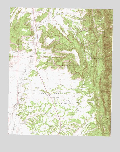
La Ventana, NM USGS Topographic Map
Click on map above to begin viewing in our Map Viewer.

This topographic map contains these locations and features:
Feature Name Type Latitude Longitude GNIS ID View Map
Arroyo de los PinosStreamN35.8545°W106.9703°903309View Map
Arroyo Dedos GordosStreamN35.7870°W106.9845°903375View Map
Arroyo Veguita BlancaStreamN35.7911°W106.9823°903434View Map
Carlisle ProspectMineN35.8600°W106.9720°915611View Map
De Dos Gordos ProspectMineN35.7981°W106.8995°916262View Map
Hoye MineMineN35.8597°W106.9831°915590View Map
J Herrera SpringsSpringN35.8714°W106.9306°914421View Map
Jones ProspectMineN35.8600°W106.9720°915501View Map
La VentanaMineN35.8667°W106.9506°917078View Map
La Ventana (historical)LocaleN35.8272°W106.9717°902660View Map
LaVentanaPopulated PlaceN35.8272°W106.9714°907733View Map
Luciani MinesMineN35.8314°W106.9920°2038556View Map
Mitchell ProspectMineN35.8509°W106.9717°915594View Map
Nance MineMineN35.8339°W106.9542°916283View Map
North Butte ProspectMineN35.8422°W106.9537°917720View Map
Ojo del Espiritu Santo GrantCivilN35.7814°W106.9370°915873View Map
Peacock Number ThreeMineN35.8328°W106.9823°915618View Map
Rio Puerco MineMineN35.8597°W106.9831°917713View Map
Rio Puerco MineMineN35.8231°W106.9698°917079View Map
Rio Puerco MineMineN35.7695°W106.9917°916307View Map
Rito OlguinStreamN35.7550°W106.9923°910307View Map
RWP 7 Water WellWellN35.7978°W106.9117°922717View Map
RWP-8 Water WellWellN35.7778°W106.9745°922716View Map
San Juan MineMineN35.8231°W106.9698°917080View Map
San Miguel GroupMineN35.8667°W106.8878°916278View Map
San Miguel MinesMineN35.8661°W106.8875°910689View Map
Sandoval Coal Company ProspectMineN35.7784°W106.9920°917717View Map
South Butte ProspectMineN35.8131°W106.9153°915624View Map
South Fork Arroyo de los PinosStreamN35.8636°W106.9489°911228View Map
Thompson SpringSpringN35.7967°W106.9161°911669View Map
Wilkins Number 2 MineMineN35.8231°W106.9698°939941View Map
Wilkins Number Two MineMineN35.8428°W106.9162°916342View Map

Note: Coordinates in the location and feature list above are referenced to NAD83 datum.


Copyright (C) 2008-2024 Ryan Niemi / Sunset Dynamics ... All Rights Reserved