TopoQuest Logo
Do you find TopoQuest useful?
Help keep TopoQuest running and adding new maps/features by donating!
Bitcoin:  19c7KJd3qBynnjoSw5npx9KScwjBe4ifkT
Litecoin:  LXs6TkuXGGXo1vDsWCkWVdjQX94eUKd6ui
Home View Maps Find Maps Find Places Resources & Links


Lac Sainte Agnes, Louisiana Topographic Map

USGS Map Title: Lac Sainte Agnes, LA
USGS Map MRC: 31091B8
DRG (GeoTIFF) Download: o31091b8.tif


Neighboring USGS Topographic Map Quads:


  Powell Point, LA  
31092C1
 

  Larto Lake South, LA  
31091C8
 

  Acme, LA  
31091C7
 

  Marksville North, LA  
31092B1
 

  Lac Sainte Agnes, LA  
31091B8
 

  Ile Natchitoches, LA  
31091B7
 

  Marksville South, LA  
31092A1
 

  Moreauville, LA  
31091A8
 

  Big Bend, LA  
31091A7


Map MRC Location:

N32°
W92°
N32°
W91°
H8 H7 H6 H5 H4 H3 H2 H1
G8 G7 G6 G5 G4 G3 G2 G1
F8 F7 F6 F5 F4 F3 F2 F1
E8 E7 E6 E5 E4 E3 E2 E1
D8 D7 D6 D5 D4 D3 D2 D1
C8 C7 C6 C5 C4 C3 C2 C1
B8 B7 B6 B5 B4 B3 B2 B1
A8 A7 A6 A5 A4 A3 A2 A1
N31°
W92°
N31°
W91°

Lac Sainte Agnes, LA USGS 1:24K Topographic Map Preview:
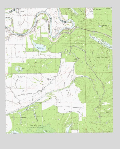
Lac Sainte Agnes, LA USGS Topographic Map
Click on map above to begin viewing in our Map Viewer.

This topographic map contains these locations and features:
Feature Name Type Latitude Longitude GNIS ID View Map
Baie SecBayN31.1502°W91.9726°540744View Map
Bayou ChambréSwampN31.1669°W91.9432°556530View Map
Bayou CocodrieStreamN31.1530°W91.9737°532531View Map
Bayou de la GlaiseStreamN31.1349°W91.8904°553401View Map
Bayou La CroixSwampN31.2002°W91.9001°540679View Map
Bayou La TaureSwampN31.1974°W91.9001°540677View Map
Bayou VoicheStreamN31.1707°W91.9268°541911View Map
Bayou VoincheLakeN31.1691°W91.9265°1630028View Map
Big CanalStreamN31.1569°W91.8898°533056View Map
Bill Book LakeSwampN31.2346°W91.9712°533117View Map
Cyprière à Oncle JohnSwampN31.2002°W91.8873°541914View Map
Grand CyprièreSwampN31.1752°W91.8835°556528View Map
Indian Cypress BrakeSwampN31.1802°W91.9521°535925View Map
La Coulee à ElphegeStreamN31.1544°W91.9682°536238View Map
La Paries ChurchChurchN31.2230°W91.9929°536242View Map
La SaulièreSwampN31.1446°W91.8835°556516View Map
Lac a PaulSwampN31.1943°W91.8790°1630030View Map
Lac AmbroiseSwampN31.1583°W91.9126°553296View Map
Lac BarbueSwampN31.1585°W91.8757°540684View Map
Lac Bryon de ChatsLakeN31.1816°W91.9079°555621View Map
Lac ClairSwampN31.1548°W91.8856°553995View Map
Lac en TraversLakeN31.1585°W91.9418°556534View Map
Lac Grand BayouLakeN31.1468°W91.9801°554569View Map
Lac MoreauLakeN31.2396°W91.9525°555367View Map
Lac OpheliaLakeN31.2143°W91.8848°555567View Map
Lac Sainte AgnesLakeN31.2110°W91.9596°555877View Map
Lac SaulièreLakeN31.1899°W91.9824°556080View Map
Lac ValerieLakeN31.1274°W91.9551°556320View Map
Lake Frazier SwampSwampN31.2352°W91.9326°536282View Map
Lake Little SolierLakeN31.1949°W91.9968°555099View Map
Lake Ophelia National Wildlife RefugeParkN31.2045°W91.8969°2765366View Map
Lake Ophelia Oil FieldOilfieldN31.2196°W91.9007°558845View Map
Little River Oil FieldOilfieldN31.1674°W91.9546°545533View Map
Long ForkStreamN31.2055°W91.9348°536692View Map
Louisiana Delta South End Landing StripAirportN31.2463°W91.9821°546033View Map
Mouillere a DehorsLakeN31.2315°W91.8893°555383View Map
Old Red RiverStreamN31.2307°W91.9946°555546View Map
Parish Governing Authority District 3CivilN31.1914°W91.9382°1929937View Map
Petit Lac du Grand BryonLakeN31.1285°W91.9274°555633View Map
Petit Lac SaulièreLakeN31.1946°W91.9965°1629908View Map
Pointe TournantCapeN31.1991°W91.9185°538312View Map
Saint James ChapelChurchN31.2363°W91.9501°555891View Map
Short ForkStreamN31.1713°W91.9935°539353View Map
Twisty BayouStreamN31.2110°W91.9660°540068View Map
Westcut LakeLakeN31.2496°W91.9216°556397View Map

Note: Coordinates in the location and feature list above are referenced to NAD83 datum.


Copyright (C) 2008-2025 Ryan Niemi / Sunset Dynamics ... All Rights Reserved