TopoQuest Logo
Do you find TopoQuest useful?
Help keep TopoQuest running and adding new maps/features by donating!
Bitcoin:  19c7KJd3qBynnjoSw5npx9KScwjBe4ifkT
Litecoin:  LXs6TkuXGGXo1vDsWCkWVdjQX94eUKd6ui
Home View Maps Find Maps Find Places Resources & Links


Big Bend, Louisiana Topographic Map

USGS Map Title: Big Bend, LA
USGS Map MRC: 31091A7
DRG (GeoTIFF) Download: o31091a7.tif


Neighboring USGS Topographic Map Quads:


  Lac Sainte Agnes, LA  
31091B8
 

  Ile Natchitoches, LA  
31091B7
 

  Lower Sunk Lake, LA  
31091B6
 

  Moreauville, LA  
31091A8
 

  Big Bend, LA  
31091A7
 

  Turnbull Island, LA  
31091A6
 

  Plaucheville, LA  
30091H8
 

  Simmesport, LA  
30091H7
 

  Innis, LA  
30091H6


Map MRC Location:

N32°
W92°
N32°
W91°
H8 H7 H6 H5 H4 H3 H2 H1
G8 G7 G6 G5 G4 G3 G2 G1
F8 F7 F6 F5 F4 F3 F2 F1
E8 E7 E6 E5 E4 E3 E2 E1
D8 D7 D6 D5 D4 D3 D2 D1
C8 C7 C6 C5 C4 C3 C2 C1
B8 B7 B6 B5 B4 B3 B2 B1
A8 A7 A6 A5 A4 A3 A2 A1
N31°
W92°
N31°
W91°

Big Bend, LA USGS 1:24K Topographic Map Preview:
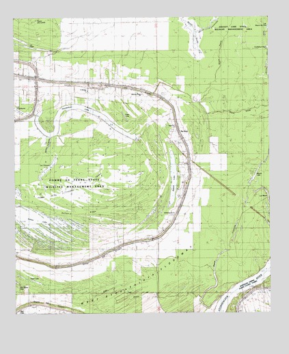
Big Bend, LA USGS Topographic Map
Click on map above to begin viewing in our Map Viewer.

This topographic map contains these locations and features:
Feature Name Type Latitude Longitude GNIS ID View Map
Antioch ChurchChurchN31.0966°W91.8471°532183View Map
Bayou CourvilleStreamN31.0071°W91.7737°534196View Map
Bayou des Glaises ChurchChurchN31.0935°W91.8126°541930View Map
Bayou PatassaStreamN31.0746°W91.8571°553502View Map
Belson LakeLakeN31.0567°W91.7975°553596View Map
Big BendPopulated PlaceN31.0738°W91.7921°553630View Map
Fish BayouStreamN31.0063°W91.7840°534959View Map
Horseshoe LakeLakeN31.0865°W91.8395°554769View Map
Lac à GuillaumeLakeN31.0855°W91.8721°554629View Map
Lac MamaLakeN31.0502°W91.7512°555233View Map
Lac PatassaLakeN31.0598°W91.8609°555602View Map
Marais a RocheSwampN31.1224°W91.7848°536888View Map
Muscle LakeLakeN31.0602°W91.7560°555448View Map
Old Morning Star ChurchChurchN31.0416°W91.7973°537838View Map
Otter LakeLakeN31.0837°W91.8211°555572View Map
Parish Governing Authority District 7CivilN31.0763°W91.8658°1930175View Map
Pilgrim ChurchChurchN31.0793°W91.7962°538139View Map
Pomme De Terre State Wildlife Management AreaParkN31.0557°W91.8446°541928View Map
Pomme De Terre SwampSwampN31.0562°W91.8418°538326View Map
Red FishPopulated PlaceN31.0016°W91.8726°556655View Map
Saint James ChurchChurchN31.0938°W91.8157°538857View Map
Saint Michaels ChurchChurchN31.0941°W91.8390°541929View Map
Sutton LakeLakeN31.0400°W91.8661°556178View Map
Sutton RidgeRidgeN31.0427°W91.8368°539748View Map
Tilden LakeLakeN31.0143°W91.8670°556247View Map
Ward SixCivilN31.1063°W91.8701°544915View Map

Note: Coordinates in the location and feature list above are referenced to NAD83 datum.


Copyright (C) 2008-2025 Ryan Niemi / Sunset Dynamics ... All Rights Reserved