TopoQuest Logo
Do you find TopoQuest useful?
Help keep TopoQuest running and adding new maps/features by donating!
Bitcoin:  19c7KJd3qBynnjoSw5npx9KScwjBe4ifkT
Litecoin:  LXs6TkuXGGXo1vDsWCkWVdjQX94eUKd6ui
Home View Maps Find Maps Find Places Resources & Links


Powell Point, Louisiana Topographic Map

USGS Map Title: Powell Point, LA
USGS Map MRC: 31092C1
DRG (GeoTIFF) Download: o31092c1.tif


Neighboring USGS Topographic Map Quads:


  Holloway, LA  
31092D2
 

  Buckeye NE, LA  
31092D1
 

  Larto Lake North, LA  
31091D8
 

  Buckeye, LA  
31092C2
 

  Powell Point, LA  
31092C1
 

  Larto Lake South, LA  
31091C8
 

  Effie, LA  
31092B2
 

  Marksville North, LA  
31092B1
 

  Lac Sainte Agnes, LA  
31091B8


Map MRC Location:

N32°
W93°
N32°
W92°
H8 H7 H6 H5 H4 H3 H2 H1
G8 G7 G6 G5 G4 G3 G2 G1
F8 F7 F6 F5 F4 F3 F2 F1
E8 E7 E6 E5 E4 E3 E2 E1
D8 D7 D6 D5 D4 D3 D2 D1
C8 C7 C6 C5 C4 C3 C2 C1
B8 B7 B6 B5 B4 B3 B2 B1
A8 A7 A6 A5 A4 A3 A2 A1
N31°
W93°
N31°
W92°

Powell Point, LA USGS 1:24K Topographic Map Preview:
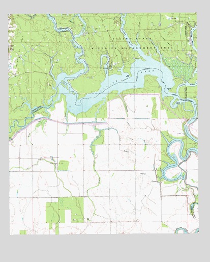
Powell Point, LA USGS Topographic Map
Click on map above to begin viewing in our Map Viewer.

This topographic map contains these locations and features:
Feature Name Type Latitude Longitude GNIS ID View Map
Big Bayou FriejonStreamN31.3268°W92.0610°553629View Map
Big CreekStreamN31.3307°W92.0910°553636View Map
Big Island Oil FieldOilfieldN31.3510°W92.1182°533089View Map
Big PointCapeN31.3393°W92.0437°533098View Map
Big Saline BayouStreamN31.3391°W92.0874°533103View Map
Bushyhead BayouGutN31.3699°W92.0076°533581View Map
Camels SloughStreamN31.3221°W92.1096°533643View Map
Camp BranchStreamN31.3043°W92.0521°533651View Map
Campright BrakeSwampN31.3441°W92.0101°545906View Map
Castoff SloughStreamN31.2821°W92.0237°533807View Map
Castoff SloughStreamN31.3096°W92.0637°533808View Map
Counterfeit RidgeRidgeN31.3146°W92.0293°545501View Map
Deville CemeteryCemeteryN31.3571°W92.1235°534513View Map
Gum RidgeRidgeN31.2980°W92.0279°545522View Map
Horse IslandIslandN31.3246°W92.0146°535804View Map
Horseshoe Lake (historical)LakeN31.3305°W92.0896°545528View Map
Jumping BayouGutN31.3157°W92.0462°536134View Map
Jumping BayouStreamN31.3410°W92.0490°536135View Map
Little Bayou FriejonStreamN31.2582°W92.0707°536486View Map
Middle BayouGutN31.3116°W92.1068°537051View Map
Middle Bayou Oil FieldOilfieldN31.2910°W92.0926°537056View Map
Muddy BayouStreamN31.3496°W92.0323°537480View Map
Muddy SloughStreamN31.3563°W92.0390°537483View Map
Nolan BayouGutN31.3449°W92.0590°555504View Map
Nolans Bayou Oil FieldOilfieldN31.3543°W92.0515°545951View Map
North Saline Lake Oil FieldOilfieldN31.3702°W92.0268°555509View Map
Old Saline BayouGutN31.3066°W92.0068°555555View Map
Open BayouStreamN31.3371°W92.0932°537883View Map
Pointe SalineCapeN31.2502°W92.0001°540746View Map
Powell PointCapeN31.3310°W92.0190°538377View Map
Raccoon BayouGutN31.3143°W92.0862°538468View Map
Racoon Lake (historical)LakeN31.3202°W92.0762°545566View Map
Saint Leo Church Oil FieldOilfieldN31.2635°W92.0079°545575View Map
Saline LakeLakeN31.3360°W92.0446°555959View Map
Shoe BayouStreamN31.3227°W92.0010°539349View Map
Taylor BayouStreamN31.3471°W92.0237°539795View Map
Vick Oil FieldOilfieldN31.2549°W92.0710°545585View Map

Note: Coordinates in the location and feature list above are referenced to NAD83 datum.


Copyright (C) 2008-2025 Ryan Niemi / Sunset Dynamics ... All Rights Reserved