TopoQuest Logo
Do you find TopoQuest useful?
Help keep TopoQuest running and adding new maps/features by donating!
Bitcoin:  19c7KJd3qBynnjoSw5npx9KScwjBe4ifkT
Litecoin:  LXs6TkuXGGXo1vDsWCkWVdjQX94eUKd6ui
Home View Maps Find Maps Find Places Resources & Links


Lacarne, Ohio Topographic Map

USGS Map Title: Lacarne, OH
USGS Map MRC: 41083E1
DRG (GeoTIFF) Download: o41083e1.tif


Neighboring USGS Topographic Map Quads:


  Metzger Marsh, OH  
41083F2


  Oak Harbor, OH  
41083E2
 

  Lacarne, OH  
41083E1
 

  Port Clinton, OH  
41082E8
 

  Lindsey, OH  
41083D2
 

  Wightmans Grove, OH  
41083D1
 

  Vickery, OH  
41082D8


Map MRC Location:

N42°
W84°
N42°
W83°
H8 H7 H6 H5 H4 H3 H2 H1
G8 G7 G6 G5 G4 G3 G2 G1
F8 F7 F6 F5 F4 F3 F2 F1
E8 E7 E6 E5 E4 E3 E2 E1
D8 D7 D6 D5 D4 D3 D2 D1
C8 C7 C6 C5 C4 C3 C2 C1
B8 B7 B6 B5 B4 B3 B2 B1
A8 A7 A6 A5 A4 A3 A2 A1
N41°
W84°
N41°
W83°

Lacarne, OH USGS 1:24K Topographic Map Preview:
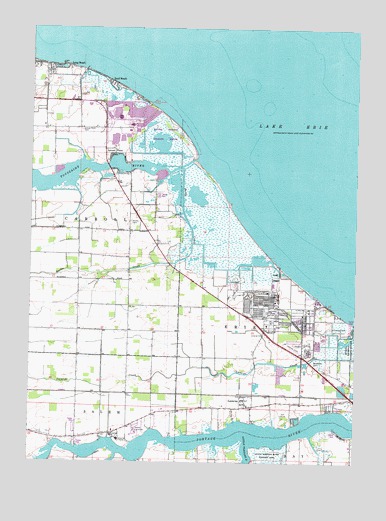
Lacarne, OH USGS Topographic Map
Click on map above to begin viewing in our Map Viewer.

This topographic map contains these locations and features:
Feature Name Type Latitude Longitude GNIS ID View Map
Camp PearyLocaleN41.5409°W83.0199°1060919View Map
Camp Perry Air National Guard StationMilitaryN41.5412°W83.0212°2512068View Map
Davis-Besse HeliportAirportN41.5981°W83.0852°1082915View Map
Davis-Besse Nuclear Power PlantLocaleN41.5972°W83.0872°1806459View Map
Erie Ordnance Depot (historical)MilitaryN41.5458°W83.0361°1065883View Map
Erie Township Volunteer Fire DepartmentBuildingN41.5163°W83.0423°2549675View Map
Green BayouStreamN41.5023°W83.0913°1041096View Map
LacarnePopulated PlaceN41.5159°W83.0421°1064958View Map
Lacarne Post OfficePost OfficeN41.5153°W83.0416°2041513View Map
Lacarpe CemeteryCemeteryN41.5367°W83.0345°1071169View Map
Lacarpe CreekStreamN41.5403°W83.0005°1042361View Map
Little Portage RiverStreamN41.5053°W83.0405°1042683View Map
Locust PointPopulated PlaceN41.5884°W83.0938°1065715View Map
Locust PointCliffN41.5884°W83.0944°1042712View Map
Locust Point CemeteryCemeteryN41.5957°W83.1058°1048341View Map
Long BeachPopulated PlaceN41.6142°W83.1121°1048931View Map
Navarre MarshSwampN41.5931°W83.0749°1806464View Map
Ottawa CountyCivilN41.5939°W83.0200°1074074View Map
Ottawa County FairgroundsLocaleN41.5070°W83.0852°1071167View Map
Ottawa County HomeLocaleN41.5064°W83.0919°1071168View Map
Ottawa County Nursing HomeBuildingN41.5064°W83.0908°1049687View Map
Port Clinton Golf CourseLocaleN41.5142°W83.0269°1049688View Map
Port Clinton LandfillLocaleN41.5242°W83.0328°2635454View Map
Riverview SchoolSchoolN41.5076°W83.0930°1071166View Map
Rusha CreekStreamN41.5845°W83.0669°1045281View Map
Sand BeachPopulated PlaceN41.6098°W83.0958°1049150View Map
Sand Beach MarshSwampN41.6067°W83.0956°1806466View Map
Toussaint MarshSwampN41.5687°W83.0534°1806468View Map
Toussaint RiverStreamN41.5873°W83.0633°1047099View Map
Township of CarrollCivilN41.6054°W83.1021°1086757View Map
Witts OrchardsLocaleN41.5814°W83.0878°2518658View Map

Note: Coordinates in the location and feature list above are referenced to NAD83 datum.


Copyright (C) 2008-2025 Ryan Niemi / Sunset Dynamics ... All Rights Reserved