TopoQuest Logo
Do you find TopoQuest useful?
Help keep TopoQuest running and adding new maps/features by donating!
Bitcoin:  19c7KJd3qBynnjoSw5npx9KScwjBe4ifkT
Litecoin:  LXs6TkuXGGXo1vDsWCkWVdjQX94eUKd6ui
Home View Maps Find Maps Find Places Resources & Links


Wightmans Grove, Ohio Topographic Map

USGS Map Title: Wightmans Grove, OH
USGS Map MRC: 41083D1
DRG (GeoTIFF) Download: o41083d1.tif


Neighboring USGS Topographic Map Quads:


  Oak Harbor, OH  
41083E2
 

  Lacarne, OH  
41083E1
 

  Port Clinton, OH  
41082E8
 

  Lindsey, OH  
41083D2
 

  Wightmans Grove, OH  
41083D1
 

  Vickery, OH  
41082D8
 

  Fremont West, OH  
41083C2
 

  Fremont East, OH  
41083C1
 

  Clyde, OH  
41082C8


Map MRC Location:

N42°
W84°
N42°
W83°
H8 H7 H6 H5 H4 H3 H2 H1
G8 G7 G6 G5 G4 G3 G2 G1
F8 F7 F6 F5 F4 F3 F2 F1
E8 E7 E6 E5 E4 E3 E2 E1
D8 D7 D6 D5 D4 D3 D2 D1
C8 C7 C6 C5 C4 C3 C2 C1
B8 B7 B6 B5 B4 B3 B2 B1
A8 A7 A6 A5 A4 A3 A2 A1
N41°
W84°
N41°
W83°

Wightmans Grove, OH USGS 1:24K Topographic Map Preview:
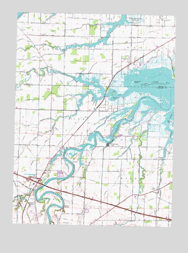
Wightmans Grove, OH USGS Topographic Map
Click on map above to begin viewing in our Map Viewer.

This topographic map contains these locations and features:
Feature Name Type Latitude Longitude GNIS ID View Map
Apollo Mobile Home ParkPopulated PlaceN41.4411°W83.0808°2678419View Map
Bark CreekStreamN41.4187°W83.0721°1037633View Map
Bay Township Fire DepartmentBuildingN41.4786°W83.0200°2549677View Map
BooktownPopulated PlaceN41.3889°W83.1080°1062656View Map
Brier Hill CemeteryCemeteryN41.4103°W83.0946°1038308View Map
Buehler DitchCanalN41.3987°W83.0469°1038491View Map
Cottonwood SwaleStreamN41.4806°W83.1110°1039392View Map
Druckenmiller DitchCanalN41.4489°W83.1013°1039790View Map
Dutch GapGapN41.4526°W83.0255°1039898View Map
Elm PointCapeN41.4526°W83.0458°1040161View Map
Fishing CreekStreamN41.4367°W83.0935°1040467View Map
Foust CemeteryCemeteryN41.3779°W83.0599°1040624View Map
Gibbs CemeteryCemeteryN41.4076°W83.0216°1960268View Map
Gibbs FarmsLocaleN41.3928°W83.0103°2678426View Map
Gibbs FieldAirportN41.4158°W83.0180°1082700View Map
Gonya FarmsLocaleN41.4419°W83.0533°2678432View Map
Green CreekStreamN41.4434°W83.0116°1066024View Map
Green Creek Hunting ClubLocaleN41.4353°W83.0257°1077501View Map
Greenwood CemeteryCemeteryN41.4281°W83.1060°1963237View Map
Greesman DitchCanalN41.4203°W83.1024°1041175View Map
Harder FarmLocaleN41.4383°W83.1089°2678434View Map
Horseshoe IslandIslandN41.4598°W83.0344°1041807View Map
Interchange 6CrossingN41.4014°W83.1121°1080273View Map
Lathrop CemeteryCemeteryN41.3928°W83.0110°1960271View Map
Little Muddy CreekStreamN41.4514°W83.0569°1066077View Map
Little Portage River Wildlife AreaParkN41.4912°W83.0319°1080012View Map
Mehlow DitchCanalN41.4914°W83.0763°1043210View Map
Memory MarinaLocaleN41.4209°W83.0624°1083431View Map
Muddy CreekStreamN41.4551°W83.0349°1057860View Map
Muddy Creek BayBayN41.4562°W83.0021°1043713View Map
Muncie HollowPopulated PlaceN41.3859°W83.0846°1065083View Map
Muskellunge CreekStreamN41.3945°W83.1074°1066272View Map
Negro PointCapeN41.3898°W83.1046°1067211View Map
Ottawa Shooting ClubLocaleN41.4384°W83.0377°1077502View Map
Paul Murray Wildlife AreaParkN41.3926°W83.0583°1960342View Map
Polter's Berry FarmLocaleN41.3769°W83.0433°2678433View Map
Poplar PointCapeN41.4542°W83.0502°1044693View Map
Redhead CoveBayN41.4514°W83.0483°1044907View Map
Riley CenterLocaleN41.3970°W83.0119°1045022View Map
Riverfront MarinaLocaleN41.4203°W83.0866°1083433View Map
Riviera Mobile ManorPopulated PlaceN41.3814°W83.1097°2678415View Map
Rusha CemeteryCemeteryN41.4914°W83.1221°1057976View Map
Saint Pauls ChurchChurchN41.4892°W83.1216°1045722View Map
Saint Philomena CemeteryCemeteryN41.4256°W83.0671°1963242View Map
Sandusky RiverStreamN41.4478°W83.0027°1066185View Map
Sandusky River Yacht and Outboard ClubLocaleN41.4273°W83.0469°1077503View Map
Schlegels GrovePopulated PlaceN41.3920°W83.0874°1063002View Map
ShannonPopulated PlaceN41.4117°W83.0788°1049169View Map
Shorewood VillagePopulated PlaceN41.4048°W83.0883°1083435View Map
Township of BayCivilN41.4843°W83.0087°1086755View Map
Township of RiceCivilN41.4365°W83.1080°1086914View Map
Township of RileyCivilN41.3954°W83.0076°1086915View Map
Trinity CemeteryCemeteryN41.4281°W83.1060°1960345View Map
Trinity Lutheran ChurchChurchN41.4278°W83.1063°1068227View Map
UptonPopulated PlaceN41.4151°W83.0113°1063074View Map
West Bay ClubLocaleN41.4631°W83.0421°1083415View Map
Wightmans GrovePopulated PlaceN41.4226°W83.0519°1049329View Map
Wightmans Grove Census Designated PlaceCensusN41.4241°W83.0466°2584371View Map
Yauch DitchCanalN41.4731°W83.1135°1048182View Map
Yellow SwaleStreamN41.4448°W83.0157°1058153View Map
Zimmerman Airport (historical)AirportN41.3758°W83.0853°1082699View Map

Note: Coordinates in the location and feature list above are referenced to NAD83 datum.


Copyright (C) 2008-2025 Ryan Niemi / Sunset Dynamics ... All Rights Reserved