TopoQuest Logo
Do you find TopoQuest useful?
Help keep TopoQuest running and adding new maps/features by donating!
Bitcoin:  19c7KJd3qBynnjoSw5npx9KScwjBe4ifkT
Litecoin:  LXs6TkuXGGXo1vDsWCkWVdjQX94eUKd6ui
Home View Maps Find Maps Find Places Resources & Links


Lindsey, Ohio Topographic Map

USGS Map Title: Lindsey, OH
USGS Map MRC: 41083D2
DRG (GeoTIFF) Download: o41083d2.tif


Neighboring USGS Topographic Map Quads:


  Genoa, OH  
41083E3
 

  Oak Harbor, OH  
41083E2
 

  Lacarne, OH  
41083E1
 

  Elmore, OH  
41083D3
 

  Lindsey, OH  
41083D2
 

  Wightmans Grove, OH  
41083D1
 

  Helena, OH  
41083C3
 

  Fremont West, OH  
41083C2
 

  Fremont East, OH  
41083C1


Map MRC Location:

N42°
W84°
N42°
W83°
H8 H7 H6 H5 H4 H3 H2 H1
G8 G7 G6 G5 G4 G3 G2 G1
F8 F7 F6 F5 F4 F3 F2 F1
E8 E7 E6 E5 E4 E3 E2 E1
D8 D7 D6 D5 D4 D3 D2 D1
C8 C7 C6 C5 C4 C3 C2 C1
B8 B7 B6 B5 B4 B3 B2 B1
A8 A7 A6 A5 A4 A3 A2 A1
N41°
W84°
N41°
W83°

Lindsey, OH USGS 1:24K Topographic Map Preview:
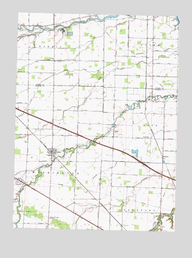
Lindsey, OH USGS Topographic Map
Click on map above to begin viewing in our Map Viewer.

This topographic map contains these locations and features:
Feature Name Type Latitude Longitude GNIS ID View Map
Bethel United Brethren ChurchChurchN41.4734°W83.2221°1037951View Map
Binkley CemeteryCemeteryN41.3839°W83.1360°1963232View Map
HessvillePopulated PlaceN41.4017°W83.2444°1064827View Map
Hessville CemeteryCemeteryN41.3945°W83.2466°1960269View Map
Hessville Census Designated PlaceCensusN41.4031°W83.2431°2584363View Map
Hessville Post Office (historical)Post OfficeN41.4014°W83.2444°2044072View Map
Hineline CemeteryCemeteryN41.4337°W83.1741°1960270View Map
Indian CreekStreamN41.4692°W83.1733°1041953View Map
KingswayPopulated PlaceN41.4176°W83.1355°1062839View Map
Kingsway Post Office (historical)Post OfficeN41.4181°W83.1360°2056992View Map
LindseyPopulated PlaceN41.4189°W83.2213°1065001View Map
Lindsey CemeteryCemeteryN41.4206°W83.2124°1960272View Map
Lindsey Post OfficePost OfficeN41.4195°W83.2208°2044079View Map
Lindsey Volunteer Fire DepartmentBuildingN41.4196°W83.2210°2549306View Map
Ninemile CreekStreamN41.4689°W83.1733°1043879View Map
Overmyer CemeteryCemeteryN41.4159°W83.2213°1960274View Map
Roose CemeteryCemeteryN41.4945°W83.1269°1048367View Map
Saint Pauls CemeteryCemeteryN41.4325°W83.1730°1960276View Map
Saint Pauls ChurchChurchN41.4323°W83.1741°1045772View Map
Sandusky Township Fire Department and Emergency Medical ServicesBuildingN41.3771°W83.1343°2550549View Map
Sugar CreekStreamN41.4903°W83.2302°1046799View Map
Township of SalemCivilN41.4942°W83.1255°1086765View Map
Township of SanduskyCivilN41.3833°W83.1307°1086916View Map
Township of WashingtonCivilN41.3999°W83.2419°1086919View Map
Trinity United Methodist ChurchChurchN41.4192°W83.2191°1067692View Map
Village of LindseyCivilN41.4217°W83.2210°2398446View Map
Washington Township SchoolSchoolN41.4176°W83.2224°1056125View Map

Note: Coordinates in the location and feature list above are referenced to NAD83 datum.


Copyright (C) 2008-2025 Ryan Niemi / Sunset Dynamics ... All Rights Reserved