TopoQuest Logo
Do you find TopoQuest useful?
Help keep TopoQuest running and adding new maps/features by donating!
Bitcoin:  19c7KJd3qBynnjoSw5npx9KScwjBe4ifkT
Litecoin:  LXs6TkuXGGXo1vDsWCkWVdjQX94eUKd6ui
Home View Maps Find Maps Find Places Resources & Links


Barnard, Missouri Topographic Map

USGS Map Title: Barnard, MO
USGS Map MRC: 40094B7
DRG (GeoTIFF) Download: o40094b7.tif


Neighboring USGS Topographic Map Quads:


  Maryville West, MO  
40094C8
 

  Maryville East, MO  
40094C7
 

  Ravenwood, MO  
40094C6
 

  Bolckow NW, MO  
40094B8
 

  Barnard, MO  
40094B7
 

  Guilford, MO  
40094B6
 

  Fillmore, MO  
40094A8
 

  Bolckow, MO  
40094A7
 

  Whitesville, MO  
40094A6


Map MRC Location:

N41°
W95°
N41°
W94°
H8 H7 H6 H5 H4 H3 H2 H1
G8 G7 G6 G5 G4 G3 G2 G1
F8 F7 F6 F5 F4 F3 F2 F1
E8 E7 E6 E5 E4 E3 E2 E1
D8 D7 D6 D5 D4 D3 D2 D1
C8 C7 C6 C5 C4 C3 C2 C1
B8 B7 B6 B5 B4 B3 B2 B1
A8 A7 A6 A5 A4 A3 A2 A1
N40°
W95°
N40°
W94°

Barnard, MO USGS 1:24K Topographic Map Preview:
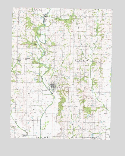
Barnard, MO USGS Topographic Map
Click on map above to begin viewing in our Map Viewer.

This topographic map contains these locations and features:
Feature Name Type Latitude Longitude GNIS ID View Map
Alumbaugh CemeteryCemeteryN40.1844°W94.8386°713255View Map
Baker CemeteryCemeteryN40.1719°W94.8639°713569View Map
BarnardPopulated PlaceN40.1744°W94.8239°713663View Map
Barnard Fire Protection District Station 1 HeadquartersBuildingN40.1756°W94.8244°2621513View Map
Barnard Post OfficePost OfficeN40.1755°W94.8249°2783107View Map
Black Oak Public AccessLocaleN40.2419°W94.8355°741736View Map
Blackoak School (historical)SchoolN40.2308°W94.8480°714332View Map
Central School (historical)SchoolN40.1664°W94.8633°715692View Map
City of BarnardCivilN40.1753°W94.8230°2394061View Map
Cottonwood CreekStreamN40.2000°W94.7744°716363View Map
Dog BranchStreamN40.2439°W94.8294°716951View Map
Dougan School (historical)SchoolN40.1378°W94.7647°717002View Map
Fairview School (historical)SchoolN40.2005°W94.8125°717824View Map
Fox SchoolSchoolN40.2292°W94.8116°718152View Map
Hannah LakeReservoirN40.1483°W94.7781°761940View Map
Hannah Lake DamDamN40.1500°W94.7769°761939View Map
Harmon School (historical)SchoolN40.1461°W94.8447°719107View Map
Jackson CemeteryCemeteryN40.1561°W94.7844°720212View Map
Liberty SchoolSchoolN40.1961°W94.7639°721005View Map
Mount Joy School (historical)SchoolN40.2439°W94.7914°722777View Map
Platte Valley CemeteryCemeteryN40.1414°W94.7694°724468View Map
Pumpkin CenterPopulated PlaceN40.2003°W94.8677°741178View Map
Salem ChurchChurchN40.2072°W94.8683°725941View Map
Skidmore School (historical)SchoolN40.1672°W94.7636°726508View Map
South Nodaway High SchoolSchoolN40.1777°W94.8215°2545105View Map
Township of GrantCivilN40.1966°W94.7907°767085View Map
White Hall School (historical)SchoolN40.1497°W94.8039°728734View Map

Note: Coordinates in the location and feature list above are referenced to NAD83 datum.


Copyright (C) 2008-2025 Ryan Niemi / Sunset Dynamics ... All Rights Reserved