TopoQuest Logo
Do you find TopoQuest useful?
Help keep TopoQuest running and adding new maps/features by donating!
Bitcoin:  19c7KJd3qBynnjoSw5npx9KScwjBe4ifkT
Litecoin:  LXs6TkuXGGXo1vDsWCkWVdjQX94eUKd6ui
Home View Maps Find Maps Find Places Resources & Links


Whitesville, Missouri Topographic Map

USGS Map Title: Whitesville, MO
USGS Map MRC: 40094A6
DRG (GeoTIFF) Download: o40094a6.tif


Neighboring USGS Topographic Map Quads:


  Barnard, MO  
40094B7
 

  Guilford, MO  
40094B6
 

  Stanberry, MO  
40094B5
 

  Bolckow, MO  
40094A7
 

  Whitesville, MO  
40094A6
 

  King City, MO  
40094A5
 

  Savannah, MO  
39094H7
 

  Helena, MO  
39094H6
 

  Union Star, MO  
39094H5


Map MRC Location:

N41°
W95°
N41°
W94°
H8 H7 H6 H5 H4 H3 H2 H1
G8 G7 G6 G5 G4 G3 G2 G1
F8 F7 F6 F5 F4 F3 F2 F1
E8 E7 E6 E5 E4 E3 E2 E1
D8 D7 D6 D5 D4 D3 D2 D1
C8 C7 C6 C5 C4 C3 C2 C1
B8 B7 B6 B5 B4 B3 B2 B1
A8 A7 A6 A5 A4 A3 A2 A1
N40°
W95°
N40°
W94°

Whitesville, MO USGS 1:24K Topographic Map Preview:
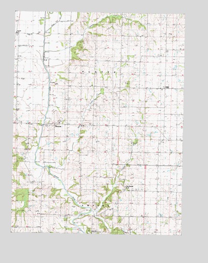
Whitesville, MO USGS Topographic Map
Click on map above to begin viewing in our Map Viewer.

This topographic map contains these locations and features:
Feature Name Type Latitude Longitude GNIS ID View Map
Agee CreekStreamN40.0383°W94.7225°713169View Map
Bennywood SchoolSchoolN40.0622°W94.6916°713961View Map
Blue School (historical)SchoolN40.0233°W94.6305°714423View Map
Bonham SchoolSchoolN40.0611°W94.6439°714522View Map
CawoodPopulated PlaceN40.1128°W94.7497°715559View Map
Clear CreekStreamN40.1133°W94.7280°715938View Map
Crooked CreekStreamN40.0122°W94.6900°716513View Map
Elrod Mill State Access AreaLocaleN40.0003°W94.6961°741735View Map
Empire PrairiePopulated PlaceN40.0830°W94.6391°740833View Map
Empire School (historical)SchoolN40.0819°W94.6400°747054View Map
Flag SpringsPopulated PlaceN40.0250°W94.6669°739987View Map
Flag Springs School (historical)SchoolN40.0172°W94.6630°717979View Map
Hannah AirportAirportN40.1059°W94.7397°758592View Map
Hickory CreekStreamN40.1036°W94.7277°719442View Map
Hickory Creek SchoolSchoolN40.1033°W94.7083°719451View Map
High Prairie School (historical)SchoolN40.1011°W94.6569°719556View Map
Miller School (historical)SchoolN40.0314°W94.6997°747055View Map
Murphy SchoolSchoolN40.0136°W94.7277°723077View Map
Township of EmpireCivilN40.0029°W94.6850°766222View Map
Township of PlatteCivilN40.0830°W94.6958°766228View Map
WhitesvillePopulated PlaceN40.0611°W94.7194°728792View Map

Note: Coordinates in the location and feature list above are referenced to NAD83 datum.


Copyright (C) 2008-2024 Ryan Niemi / Sunset Dynamics ... All Rights Reserved