TopoQuest Logo
Do you find TopoQuest useful?
Help keep TopoQuest running and adding new maps/features by donating!
Bitcoin:  19c7KJd3qBynnjoSw5npx9KScwjBe4ifkT
Litecoin:  LXs6TkuXGGXo1vDsWCkWVdjQX94eUKd6ui
Home View Maps Find Maps Find Places Resources & Links


Lairdsville, Pennsylvania Topographic Map

USGS Map Title: Lairdsville, PA
USGS Map MRC: 41076B5
DRG (GeoTIFF) Download: o41076b5.tif


Neighboring USGS Topographic Map Quads:


  Picture Rocks, PA  
41076C6
 

  Sonestown, PA  
41076C5
 

  Elk Grove, PA  
41076C4
 

  Hughesville, PA  
41076B6
 

  Lairdsville, PA  
41076B5
 

  Benton, PA  
41076B4
 

  Washingtonville, PA  
41076A6
 

  Millville, PA  
41076A5
 

  Bloomsburg, PA  
41076A4


Map MRC Location:

N42°
W77°
N42°
W76°
H8 H7 H6 H5 H4 H3 H2 H1
G8 G7 G6 G5 G4 G3 G2 G1
F8 F7 F6 F5 F4 F3 F2 F1
E8 E7 E6 E5 E4 E3 E2 E1
D8 D7 D6 D5 D4 D3 D2 D1
C8 C7 C6 C5 C4 C3 C2 C1
B8 B7 B6 B5 B4 B3 B2 B1
A8 A7 A6 A5 A4 A3 A2 A1
N41°
W77°
N41°
W76°

Lairdsville, PA USGS 1:24K Topographic Map Preview:
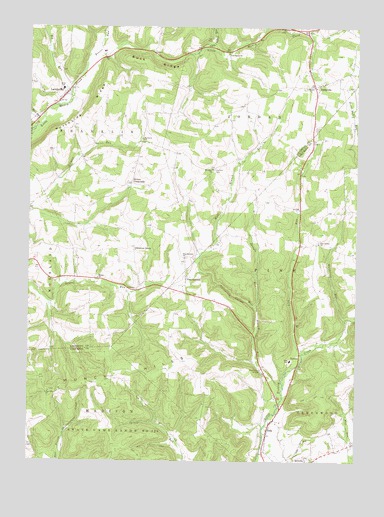
Lairdsville, PA USGS Topographic Map
Click on map above to begin viewing in our Map Viewer.

This topographic map contains these locations and features:
Feature Name Type Latitude Longitude GNIS ID View Map
A T A Memorial White Waltham Airport (historical)AirportN41.1668°W76.5663°1194185View Map
Beaver RunStreamN41.2401°W76.6030°1192109View Map
Big RunStreamN41.2317°W76.6088°1192138View Map
Buck RidgeRidgeN41.2376°W76.5755°1170534View Map
California HollowValleyN41.1693°W76.5381°1170886View Map
Chestnut GrovePopulated PlaceN41.1854°W76.5841°1203266View Map
Chestnut Grove SchoolSchoolN41.1876°W76.5850°1197415View Map
Derr RunStreamN41.2201°W76.6238°1192351View Map
Gardner School (historical)SchoolN41.2093°W76.5547°1197416View Map
Germany ChurchChurchN41.2176°W76.5811°1175568View Map
Gordner CemeteryCemeteryN41.2090°W76.5540°1175833View Map
IolaPopulated PlaceN41.1365°W76.5316°1177825View Map
Iola Census Designated PlaceCensusN41.1320°W76.5305°2389970View Map
LairdsvillePopulated PlaceN41.2292°W76.6130°1178768View Map
Lairdsville Community Volunteer Fire CompanyBuildingN41.2312°W76.6120°2652761View Map
Lairdsville Post OfficePost OfficeN41.2309°W76.6112°2772777View Map
Lick RunStreamN41.1559°W76.5199°1179300View Map
Little Indian RunStreamN41.2426°W76.5605°1179566View Map
Muney ChurchChurchN41.1779°W76.5980°1182092View Map
Northside RidgeRidgeN41.2284°W76.5997°1182675View Map
Pine Center ChurchChurchN41.1879°W76.5138°1183763View Map
Pine SchoolSchoolN41.1543°W76.5244°1183906View Map
Pine SummitPopulated PlaceN41.1779°W76.5644°1183909View Map
Pine Summit ChurchChurchN41.1837°W76.5650°1183910View Map
Renn SchoolSchoolN41.2323°W76.6119°1184898View Map
Ritters CrossroadsPopulated PlaceN41.2051°W76.5855°1204517View Map
Saint Johns ChurchChurchN41.2093°W76.5547°1186160View Map
Salem ChurchChurchN41.2326°W76.5188°1186853View Map
SerenoPopulated PlaceN41.1543°W76.5213°1204612View Map
Shingle RunStreamN41.1684°W76.5369°1187539View Map
Shoemaker BridgeBridgeN41.1515°W76.5355°1187575View Map
Star SchoolSchoolN41.2115°W76.6041°1197414View Map
State Game Lands Number 226ParkN41.1315°W76.5952°1188495View Map
SterenouvilleLocaleN41.1609°W76.5038°1207122View Map
Township of FranklinCivilN41.2323°W76.5843°1216749View Map
Township of JordanCivilN41.2443°W76.5221°1216752View Map
Township of PineCivilN41.1905°W76.5149°1216291View Map
UnityvillePopulated PlaceN41.2331°W76.5158°1190209View Map
Unityville Post OfficePost OfficeN41.2341°W76.5125°2773010View Map
Unityville Volunteer Fire CompanyBuildingN41.2328°W76.5155°2653345View Map
Van Dine ChurchChurchN41.1451°W76.6163°1190334View Map
West Branch RunStreamN41.1465°W76.5266°1190931View Map
Wolfhouse RunStreamN41.1659°W76.5033°1191700View Map

Note: Coordinates in the location and feature list above are referenced to NAD83 datum.


Copyright (C) 2008-2025 Ryan Niemi / Sunset Dynamics ... All Rights Reserved