TopoQuest Logo
Do you find TopoQuest useful?
Help keep TopoQuest running and adding new maps/features by donating!
Bitcoin:  19c7KJd3qBynnjoSw5npx9KScwjBe4ifkT
Litecoin:  LXs6TkuXGGXo1vDsWCkWVdjQX94eUKd6ui
Home View Maps Find Maps Find Places Resources & Links


Lake Ada, Minnesota Topographic Map

USGS Map Title: Lake Ada, MN
USGS Map MRC: 46094G3
DRG (GeoTIFF) Download: o46094g3.tif


Neighboring USGS Topographic Map Quads:


  Webb Lake, MN  
46094H4
 

  Woman Lake, MN  
46094H3
 

  Longville, MN  
46094H2
 

  Mildred, MN  
46094G4
 

  Lake Ada, MN  
46094G3
 

  Stewart Lake, MN  
46094G2
 

  Pine River, MN  
46094F4
 

  Jenkins, MN  
46094F3
 

  Lower Whitefish Lake, MN  
46094F2


Map MRC Location:

N47°
W95°
N47°
W94°
H8 H7 H6 H5 H4 H3 H2 H1
G8 G7 G6 G5 G4 G3 G2 G1
F8 F7 F6 F5 F4 F3 F2 F1
E8 E7 E6 E5 E4 E3 E2 E1
D8 D7 D6 D5 D4 D3 D2 D1
C8 C7 C6 C5 C4 C3 C2 C1
B8 B7 B6 B5 B4 B3 B2 B1
A8 A7 A6 A5 A4 A3 A2 A1
N46°
W95°
N46°
W94°

Lake Ada, MN USGS 1:24K Topographic Map Preview:
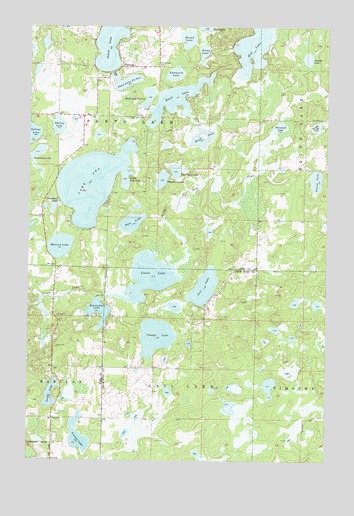
Lake Ada, MN USGS Topographic Map
Click on map above to begin viewing in our Map Viewer.

This topographic map contains these locations and features:
Feature Name Type Latitude Longitude GNIS ID View Map
Bass LakeLakeN46.8184°W94.3322°655240View Map
Blind Lake CreekStreamN46.8052°W94.3142°655436View Map
Clough LakeLakeN46.7857°W94.3216°655763View Map
Deadman LakeLakeN46.8228°W94.3645°655953View Map
East Twin LakeLakeN46.8333°W94.3140°656107View Map
Hand LakeLakeN46.8538°W94.3141°656511View Map
Harriet LakeLakeN46.8116°W94.3620°656527View Map
Hay LakeLakeN46.8698°W94.2811°656553View Map
Horseshoe LakeLakeN46.7928°W94.3457°656650View Map
Jail LakeLakeN46.7998°W94.3015°656767View Map
Lake AdaLakeN46.8298°W94.3492°655077View Map
Little Ada LakeLakeN46.8310°W94.3348°657017View Map
Lizotte LakeLakeN46.7567°W94.3538°657161View Map
Lizzie LakeLakeN46.8028°W94.3246°659992View Map
Louise LakeLakeN46.8308°W94.2549°657230View Map
Ponto LakeLakeN46.8716°W94.3403°657894View Map
Ponto Lake CemeteryCemeteryN46.8641°W94.3222°657895View Map
PontoriaPopulated PlaceN46.8633°W94.3367°657896View Map
Pontoria Post Office (historical)Post OfficeN46.8633°W94.3364°2071273View Map
Potshot LakeLakeN46.8659°W94.2588°657925View Map
Round LakeLakeN46.8715°W94.3093°658099View Map
Sand Lake Number OneLakeN46.8591°W94.3352°658154View Map
Sand Lake Number TwoLakeN46.8546°W94.3256°658155View Map
Smiley LakeLakeN46.8463°W94.3635°658309View Map
Stony LakeLakeN46.8675°W94.3027°658490View Map
Swede LakeLakeN46.7688°W94.3656°658574View Map
Swede LakeLakeN46.8463°W94.2551°658576View Map
Tamarack LakeLakeN46.8461°W94.2705°658600View Map
Tamarack LakeLakeN46.8613°W94.3148°658602View Map
Tamarack LakeLakeN46.8379°W94.3735°658608View Map
Township of BarclayCivilN46.7675°W94.3735°663505View Map
Township of Gail LakeCivilN46.7619°W94.3120°664239View Map
Township of Ponto LakeCivilN46.8489°W94.3433°665336View Map
West Twin LakeLakeN46.8308°W94.3196°658962View Map

Note: Coordinates in the location and feature list above are referenced to NAD83 datum.


Copyright (C) 2008-2024 Ryan Niemi / Sunset Dynamics ... All Rights Reserved