TopoQuest Logo
Do you find TopoQuest useful?
Help keep TopoQuest running and adding new maps/features by donating!
Bitcoin:  19c7KJd3qBynnjoSw5npx9KScwjBe4ifkT
Litecoin:  LXs6TkuXGGXo1vDsWCkWVdjQX94eUKd6ui
Home View Maps Find Maps Find Places Resources & Links


Lake Collins, Georgia Topographic Map

USGS Map Title: Lake Collins, GA
USGS Map MRC: 32084A3
DRG (GeoTIFF) Download: o32084a3.tif


Neighboring USGS Topographic Map Quads:


  Draneville, GA  
32084B4
 

  Ellaville South, GA  
32084B3
 

  Andersonville, GA  
32084B2
 

  Plains, GA  
32084A4
 

  Lake Collins, GA  
32084A3
 

  Americus, GA  
32084A2
 

  Bottsford, GA  
31084H4
 

  Smithville West, GA  
31084H3
 

  Smithville East, GA  
31084H2


Map MRC Location:

N33°
W85°
N33°
W84°
H8 H7 H6 H5 H4 H3 H2 H1
G8 G7 G6 G5 G4 G3 G2 G1
F8 F7 F6 F5 F4 F3 F2 F1
E8 E7 E6 E5 E4 E3 E2 E1
D8 D7 D6 D5 D4 D3 D2 D1
C8 C7 C6 C5 C4 C3 C2 C1
B8 B7 B6 B5 B4 B3 B2 B1
A8 A7 A6 A5 A4 A3 A2 A1
N32°
W85°
N32°
W84°

Lake Collins, GA USGS 1:24K Topographic Map Preview:
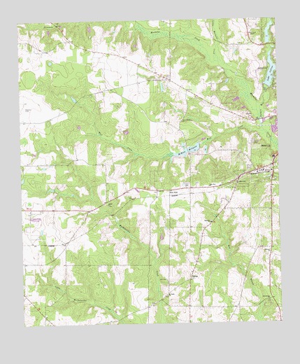
Lake Collins, GA USGS Topographic Map
Click on map above to begin viewing in our Map Viewer.

This topographic map contains these locations and features:
Feature Name Type Latitude Longitude GNIS ID View Map
Antioch CemeteryCemeteryN32.0490°W84.3327°343417View Map
Antioch ChurchChurchN32.0491°W84.3327°310570View Map
Benevolence CemeteryCemeteryN32.0093°W84.2563°343419View Map
Benevolence ChurchChurchN32.0091°W84.2557°354548View Map
Christ ChurchChurchN32.0549°W84.3085°355154View Map
Ebenezer ChurchChurchN32.0291°W84.2549°313826View Map
Friendship School (historical)SchoolN32.0071°W84.3149°343447View Map
Lake CollinsReservoirN32.1036°W84.2525°312861View Map
Lake Collins DamDamN32.0977°W84.2549°338045View Map
Lowell FieldAirportN32.0581°W84.2910°351656View Map
McMath Mill (historical)LocaleN32.0704°W84.2935°343465View Map
McMath MillpondReservoirN32.0714°W84.2932°317956View Map
McMath Millpond DamDamN32.0713°W84.2938°338041View Map
Mount Salem ChurchChurchN32.0116°W84.3046°318869View Map
Mount Salem School (historical)SchoolN32.0118°W84.3049°343471View Map
New PointPopulated PlaceN32.0549°W84.3024°332492View Map
Open Door ChurchChurchN32.0566°W84.2835°320078View Map
Parkers Mill CreekStreamN32.0841°W84.2582°356458View Map
Peterson FieldAirportN32.0904°W84.3723°351877View Map
Phoebe Sumter Medical CenterHospitalN32.0671°W84.2560°343507View Map
Plains DivisionCivilN32.0347°W84.3636°1936473View Map
Seals Mill (historical)LocaleN32.0093°W84.3094°343499View Map
Shipp ChapelChurchN32.0582°W84.2702°322914View Map
Southwest Georgia Agricultural Branch StationLocaleN32.0457°W84.3707°343503View Map
Statham LakeReservoirN32.1135°W84.2532°338044View Map
Statham Lake DamDamN32.1135°W84.2532°338043View Map
Sumter County Correctional InstitutionBuildingN32.0737°W84.2770°2735767View Map
Sumter County JailBuildingN32.0740°W84.2775°2733728View Map
ThaleanPopulated PlaceN32.0185°W84.2935°333210View Map
Thalean School (historical)SchoolN32.0213°W84.2930°343509View Map
Union Whitely ChurchChurchN32.0832°W84.2960°324590View Map
WISK-AM (Americus)TowerN32.0810°W84.2555°352331View Map
Wolf CreekStreamN32.0793°W84.2566°356648View Map
WPUR-FM (Americus)TowerN32.0810°W84.2555°352609View Map

Note: Coordinates in the location and feature list above are referenced to NAD83 datum.


Copyright (C) 2008-2024 Ryan Niemi / Sunset Dynamics ... All Rights Reserved