TopoQuest Logo
Do you find TopoQuest useful?
Help keep TopoQuest running and adding new maps/features by donating!
Bitcoin:  19c7KJd3qBynnjoSw5npx9KScwjBe4ifkT
Litecoin:  LXs6TkuXGGXo1vDsWCkWVdjQX94eUKd6ui
Home View Maps Find Maps Find Places Resources & Links


Lake Michie, North Carolina Topographic Map

USGS Map Title: Lake Michie, NC
USGS Map MRC: 36078B7
DRG (GeoTIFF) Download: o36078b7.tif


Neighboring USGS Topographic Map Quads:


  Timberlake, NC  
36078C8
 

  Moriah, NC  
36078C7
 

  Berea, NC  
36078C6
 

  Rougemont, NC  
36078B8
 

  Lake Michie, NC  
36078B7
 

  Stem, NC  
36078B6
 

  Northwest Durham, NC  
36078A8
 

  Northeast Durham, NC  
36078A7
 

  Creedmoor, NC  
36078A6


Map MRC Location:

N37°
W79°
N37°
W78°
H8 H7 H6 H5 H4 H3 H2 H1
G8 G7 G6 G5 G4 G3 G2 G1
F8 F7 F6 F5 F4 F3 F2 F1
E8 E7 E6 E5 E4 E3 E2 E1
D8 D7 D6 D5 D4 D3 D2 D1
C8 C7 C6 C5 C4 C3 C2 C1
B8 B7 B6 B5 B4 B3 B2 B1
A8 A7 A6 A5 A4 A3 A2 A1
N36°
W79°
N36°
W78°

Lake Michie, NC USGS 1:24K Topographic Map Preview:
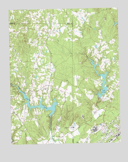
Lake Michie, NC USGS Topographic Map
Click on map above to begin viewing in our Map Viewer.

This topographic map contains these locations and features:
Feature Name Type Latitude Longitude GNIS ID View Map
Bahama Fire and Rescue Station 1BuildingN36.1678°W78.8721°2638700View Map
ButnerPopulated PlaceN36.1321°W78.7567°1019443View Map
Butner Census Designated Place (historical)CensusN36.1346°W78.7690°2402738View Map
Butner Post OfficePost OfficeN36.1351°W78.7598°2774157View Map
Butner Public Safety Fire ServiceBuildingN36.1398°W78.7647°2639309View Map
Butner-Stem Central SchoolSchoolN36.1376°W78.7603°1006630View Map
Camp Butner Wildlife Management AreaParkN36.2085°W78.7914°1006628View Map
Camp CreekStreamN36.2079°W78.7894°982520View Map
Camp MurdockLocaleN36.1782°W78.7650°982543View Map
Carrington CemeteryCemeteryN36.2199°W78.8467°982680View Map
Dial CreekStreamN36.1724°W78.8578°984163View Map
Dickens CreekStreamN36.1968°W78.7769°1023946View Map
Dillon SchoolSchoolN36.1501°W78.7925°984188View Map
Dry CreekStreamN36.1696°W78.8383°1023953View Map
Ellis ChapelChurchN36.1768°W78.8345°984734View Map
Gantt LakeReservoirN36.2051°W78.7547°1000327View Map
Gantt Lake DamDamN36.2051°W78.7547°1000328View Map
HamptonPopulated PlaceN36.2185°W78.8353°1023512View Map
Hester LakeReservoirN36.2285°W78.8164°1000385View Map
Hester Lake Number One DamDamN36.2285°W78.8164°1000386View Map
Holly Grove CampgroundLocaleN36.1651°W78.8581°986946View Map
John Umstead HospitalHospitalN36.1399°W78.7776°2701507View Map
Knap of ReedsPopulated PlaceN36.1529°W78.7789°1023549View Map
Lake ButnerReservoirN36.1668°W78.7731°1023864View Map
Lake Butner Water Supply DamDamN36.1668°W78.7731°1000247View Map
Lake MichieReservoirN36.1501°W78.8297°1024142View Map
Lake Michie DamDamN36.1501°W78.8297°1000197View Map
Mangum StorePopulated PlaceN36.1938°W78.8283°1023513View Map
Mount Calvert ChurchChurchN36.1543°W78.8711°990342View Map
Mount Tabor ChurchChurchN36.1951°W78.8456°990587View Map
Picture CreekStreamN36.1496°W78.7733°992159View Map
Polk Correctional InstitutionBuildingN36.1366°W78.7859°2769845View Map
Pyrophyllite Mine LakeReservoirN36.2335°W78.7531°1000391View Map
Pyrophyllite Mine Lake DamDamN36.2335°W78.7531°1000392View Map
Rocky CreekStreamN36.1668°W78.8272°1024273View Map
Spruce Pine CampgroundLocaleN36.1768°W78.8678°995379View Map
Town of ButnerCivilN36.1285°W78.7501°2424932View Map
Township of MangumCivilN36.1747°W78.8729°1026655View Map
WillardvillePopulated PlaceN36.1390°W78.8570°997347View Map

Note: Coordinates in the location and feature list above are referenced to NAD83 datum.


Copyright (C) 2008-2025 Ryan Niemi / Sunset Dynamics ... All Rights Reserved