TopoQuest Logo
Do you find TopoQuest useful?
Help keep TopoQuest running and adding new maps/features by donating!
Bitcoin:  19c7KJd3qBynnjoSw5npx9KScwjBe4ifkT
Litecoin:  LXs6TkuXGGXo1vDsWCkWVdjQX94eUKd6ui
Home View Maps Find Maps Find Places Resources & Links


Moriah, North Carolina Topographic Map

USGS Map Title: Moriah, NC
USGS Map MRC: 36078C7
DRG (GeoTIFF) Download: o36078c7.tif


Neighboring USGS Topographic Map Quads:


  Roxboro, NC  
36078D8
 

  Triple Springs, NC  
36078D7
 

  Satterwhite, NC  
36078D6
 

  Timberlake, NC  
36078C8
 

  Moriah, NC  
36078C7
 

  Berea, NC  
36078C6
 

  Rougemont, NC  
36078B8
 

  Lake Michie, NC  
36078B7
 

  Stem, NC  
36078B6


Map MRC Location:

N37°
W79°
N37°
W78°
H8 H7 H6 H5 H4 H3 H2 H1
G8 G7 G6 G5 G4 G3 G2 G1
F8 F7 F6 F5 F4 F3 F2 F1
E8 E7 E6 E5 E4 E3 E2 E1
D8 D7 D6 D5 D4 D3 D2 D1
C8 C7 C6 C5 C4 C3 C2 C1
B8 B7 B6 B5 B4 B3 B2 B1
A8 A7 A6 A5 A4 A3 A2 A1
N36°
W79°
N36°
W78°

Moriah, NC USGS 1:24K Topographic Map Preview:
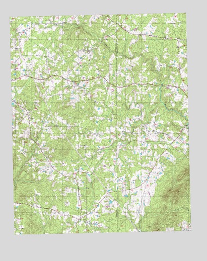
Moriah, NC USGS Topographic Map
Click on map above to begin viewing in our Map Viewer.

This topographic map contains these locations and features:
Feature Name Type Latitude Longitude GNIS ID View Map
Bethany Baptist ChurchChurchN36.2571°W78.8250°1000860View Map
Center Grove School (historical)SchoolN36.3504°W78.8350°1951347View Map
Cub CreekStreamN36.3226°W78.7667°1023935View Map
Glenns Store (historical)LocaleN36.3293°W78.8495°1952098View Map
Goshen ChapelChurchN36.3607°W78.7561°1000852View Map
MoriahPopulated PlaceN36.2576°W78.8295°990245View Map
Moriah Volunteer Fire and Rescue HeadquartersBuildingN36.2689°W78.8269°2639278View Map
Moriah Volunteer Fire and Rescue SubstationBuildingN36.3167°W78.8619°2639587View Map
Mount Harmony Baptist ChurchChurchN36.3204°W78.8633°990392View Map
Mount Harmony CemeteryCemeteryN36.3207°W78.8625°1951353View Map
Mount Tirzah SchoolSchoolN36.3168°W78.8625°990590View Map
New Saint James ChurchChurchN36.3551°W78.8233°1000854View Map
Oakleys Store (historical)LocaleN36.3271°W78.8733°1951354View Map
Peeds Store (historical)LocaleN36.3379°W78.8211°1952139View Map
Piedmont TechSchoolN36.3168°W78.8625°1000861View Map
Saint James School (historical)SchoolN36.3407°W78.8386°993922View Map
Siloam ChurchChurchN36.2826°W78.8386°1024705View Map
Siloam SchoolSchoolN36.2815°W78.8364°994807View Map
Township of Mount TirzahCivilN36.2894°W78.8589°1027049View Map
Trenton ChurchChurchN36.3660°W78.8000°996220View Map
Trinity ChurchChurchN36.3660°W78.7995°1000853View Map
Uzzles LakeReservoirN36.2568°W78.7864°1000427View Map
Uzzles Lake DamDamN36.2568°W78.7864°1000428View Map
White Rock ChurchChurchN36.3607°W78.7650°997211View Map

Note: Coordinates in the location and feature list above are referenced to NAD83 datum.


Copyright (C) 2008-2024 Ryan Niemi / Sunset Dynamics ... All Rights Reserved