TopoQuest Logo
Do you find TopoQuest useful?
Help keep TopoQuest running and adding new maps/features by donating!
Bitcoin:  19c7KJd3qBynnjoSw5npx9KScwjBe4ifkT
Litecoin:  LXs6TkuXGGXo1vDsWCkWVdjQX94eUKd6ui
Home View Maps Find Maps Find Places Resources & Links


Stem, North Carolina Topographic Map

USGS Map Title: Stem, NC
USGS Map MRC: 36078B6
DRG (GeoTIFF) Download: o36078b6.tif


Neighboring USGS Topographic Map Quads:


  Moriah, NC  
36078C7
 

  Berea, NC  
36078C6
 

  Oxford, NC  
36078C5
 

  Lake Michie, NC  
36078B7
 

  Stem, NC  
36078B6
 

  Wilton, NC  
36078B5
 

  Northeast Durham, NC  
36078A7
 

  Creedmoor, NC  
36078A6
 

  Grissom, NC  
36078A5


Map MRC Location:

N37°
W79°
N37°
W78°
H8 H7 H6 H5 H4 H3 H2 H1
G8 G7 G6 G5 G4 G3 G2 G1
F8 F7 F6 F5 F4 F3 F2 F1
E8 E7 E6 E5 E4 E3 E2 E1
D8 D7 D6 D5 D4 D3 D2 D1
C8 C7 C6 C5 C4 C3 C2 C1
B8 B7 B6 B5 B4 B3 B2 B1
A8 A7 A6 A5 A4 A3 A2 A1
N36°
W79°
N36°
W78°

Stem, NC USGS 1:24K Topographic Map Preview:
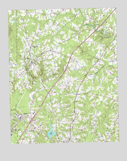
Stem, NC USGS Topographic Map
Click on map above to begin viewing in our Map Viewer.

This topographic map contains these locations and features:
Feature Name Type Latitude Longitude GNIS ID View Map
Bryant Hill School (historical)SchoolN36.2326°W78.6256°1951046View Map
Bullock ChurchChurchN36.1632°W78.6750°982236View Map
Cash LakeReservoirN36.2301°W78.7297°1000387View Map
Cattail CreekStreamN36.2332°W78.6497°1023889View Map
Cedar CreekStreamN36.1254°W78.6611°1023892View Map
Community Memorial GardensCemeteryN36.2162°W78.7214°1024503View Map
Concord ChurchChurchN36.1421°W78.7269°983438View Map
Gooch Memorial ChurchChurchN36.2026°W78.7203°985784View Map
Granville County Emergency Medical Services Station 4BuildingN36.1418°W78.7207°2720724View Map
Greenfield ChurchChurchN36.1326°W78.6322°986098View Map
Greenfield School (historical)SchoolN36.1324°W78.6325°1951049View Map
HesterPopulated PlaceN36.1701°W78.6725°986667View Map
Holman CreekStreamN36.1340°W78.7003°986971View Map
Interchange 191CrossingN36.1476°W78.7248°2455113View Map
Jackson CreekStreamN36.2376°W78.6631°987491View Map
Johnson CreekStreamN36.1974°W78.6361°987672View Map
Lake RogersLakeN36.1299°W78.7031°1024277View Map
Lake Rogers DamDamN36.1299°W78.7031°1024439View Map
Lattice Church (historical)ChurchN36.2090°W78.6911°1951052View Map
LyonsPopulated PlaceN36.1474°W78.7247°1024123View Map
Mount EnergyPopulated PlaceN36.1254°W78.6414°1024168View Map
Mount Vernon ChurchChurchN36.1340°W78.6539°990608View Map
Murdoch CenterHospitalN36.1499°W78.7378°1024180View Map
Nye Pond Dam Number OneDamN36.2018°W78.7497°1000323View Map
Nye Pond Number OneReservoirN36.2018°W78.7497°1000324View Map
Pine Grove ChurchChurchN36.1376°W78.7150°992244View Map
Pleasant Grove ChurchChurchN36.1304°W78.6347°992496View Map
Providence School (historical)SchoolN36.2451°W78.6578°1951061View Map
ShooflyPopulated PlaceN36.2226°W78.7292°1024301View Map
StemPopulated PlaceN36.1999°W78.7222°995463View Map
Stem Community Fire Department and Emergency Medical Services Station 8BuildingN36.2000°W78.7213°2638642View Map
Stem Police DepartmentBuildingN36.2000°W78.7228°2769731View Map
Stem Post OfficePost OfficeN36.2003°W78.7218°2773980View Map
Stem United Methodist ChurchChurchN36.2032°W78.7243°2652332View Map
Tallyho ChurchChurchN36.2088°W78.7111°995830View Map
Tallyho ChurchChurchN36.2115°W78.7028°995831View Map
Tallyho School (historical)SchoolN36.2082°W78.7114°1951064View Map
Tar RiverPopulated PlaceN36.1999°W78.6294°1022885View Map
Town of StemCivilN36.1962°W78.7202°2406665View Map
Township of DutchvilleCivilN36.1270°W78.7355°1026713View Map
Township of Tally HoCivilN36.2415°W78.7263°1026719View Map
Veazsys Lake DamDamN36.2301°W78.7297°1000388View Map
Winston School (historical)SchoolN36.1596°W78.6839°1951070View Map

Note: Coordinates in the location and feature list above are referenced to NAD83 datum.


Copyright (C) 2008-2024 Ryan Niemi / Sunset Dynamics ... All Rights Reserved