TopoQuest Logo
Do you find TopoQuest useful?
Help keep TopoQuest running and adding new maps/features by donating!
Bitcoin:  19c7KJd3qBynnjoSw5npx9KScwjBe4ifkT
Litecoin:  LXs6TkuXGGXo1vDsWCkWVdjQX94eUKd6ui
Home View Maps Find Maps Find Places Resources & Links


Lake Mountain, Utah Topographic Map

USGS Map Title: Lake Mountain, UT
USGS Map MRC: 40109E7
DRG (GeoTIFF) Download: o40109e7.tif


Neighboring USGS Topographic Map Quads:


  Paradise Park, UT  
40109F8
 

  Marsh Peak, UT  
40109F7
 

  Taylor Mountain, UT  
40109F6
 

  Ice Cave Peak, UT  
40109E8
 

  Lake Mountain, UT  
40109E7
 

  Dry Fork, UT  
40109E6
 

  Whiterocks, UT  
40109D8
 

  Lapoint, UT  
40109D7
 

  Vernal NW, UT  
40109D6


Map MRC Location:

N41°
W110°
N41°
W109°
H8 H7 H6 H5 H4 H3 H2 H1
G8 G7 G6 G5 G4 G3 G2 G1
F8 F7 F6 F5 F4 F3 F2 F1
E8 E7 E6 E5 E4 E3 E2 E1
D8 D7 D6 D5 D4 D3 D2 D1
C8 C7 C6 C5 C4 C3 C2 C1
B8 B7 B6 B5 B4 B3 B2 B1
A8 A7 A6 A5 A4 A3 A2 A1
N40°
W110°
N40°
W109°

Lake Mountain, UT USGS 1:24K Topographic Map Preview:
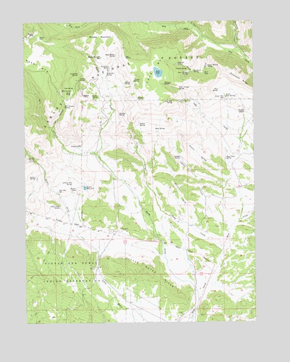
Lake Mountain, UT USGS Topographic Map
Click on map above to begin viewing in our Map Viewer.

This topographic map contains these locations and features:
Feature Name Type Latitude Longitude GNIS ID View Map
Alcorn HollowValleyN40.5583°W109.7657°1438145View Map
Bear SeepSpringN40.6035°W109.7780°1438491View Map
Bear Wallow SpringSpringN40.6033°W109.7860°1438506View Map
Beeler SpringSpringN40.5931°W109.8136°1438566View Map
Bills ParkFlatN40.5952°W109.8496°1438771View Map
Bills SpringSpringN40.5965°W109.8500°1438772View Map
Brownie CanyonValleyN40.6138°W109.7590°1439169View Map
Buckhorn SpringSpringN40.6042°W109.7836°1439246View Map
Bum SpringSpringN40.5798°W109.8039°1439318View Map
Burton ReservoirReservoirN40.5562°W109.8432°1439383View Map
Burton SeepSpringN40.5556°W109.8479°1439384View Map
Canyon SpringSpringN40.6055°W109.7865°1439473View Map
Cedar Point SpringSpringN40.5483°W109.8570°1439588View Map
Chalk CliffsCliffN40.5730°W109.8471°1439635View Map
Chenab SpringSpringN40.6007°W109.8156°1439646View Map
Chicken SpringSpringN40.6010°W109.8457°1439681View Map
Chokecherry Flat ReservoirReservoirN40.5955°W109.7607°1454704View Map
Corral SpringSpringN40.5680°W109.8702°1439981View Map
Cove SpringSpringN40.5920°W109.7866°1440076View Map
Cow SpringSpringN40.5975°W109.8487°1440094View Map
Crow CreekStreamN40.5300°W109.7688°1440170View Map
Deep Creek SpringSpringN40.5679°W109.7663°1440356View Map
Douglas SpringSpringN40.5873°W109.7555°1440535View Map
Dryland SpringSpringN40.6076°W109.7920°1440698View Map
Flat SpringSpringN40.5964°W109.7698°1441132View Map
Grouse CreekStreamN40.5361°W109.8454°1441513View Map
Grouse Flat SpringSpringN40.5581°W109.8501°1441514View Map
Gull LakeLakeN40.6039°W109.8025°1441526View Map
Indian SpringSpringN40.5823°W109.8129°1442026View Map
Jay PointCapeN40.6105°W109.8196°1442113View Map
Knoll SpringSpringN40.5691°W109.8463°1454786View Map
Lake Canyon SpringSpringN40.5968°W109.7913°1442397View Map
Lake CreekStreamN40.5758°W109.7579°1442400View Map
Lake MountainSummitN40.5966°W109.8104°1442416View Map
Lightning SpringSpringN40.6036°W109.8457°1442590View Map
Little Water HillsSummitN40.5188°W109.8026°1442807View Map
Little Water MinesMineN40.5377°W109.8224°1442808View Map
Lower Bottom SpringSpringN40.6064°W109.7755°1443000View Map
Lower Flat SeepSpringN40.5931°W109.7665°1443008View Map
Lower Flat SpringSpringN40.5938°W109.7660°1443009View Map
Lower Grouse ReservoirReservoirN40.5411°W109.8424°1454805View Map
Lyles Hole SpringSpringN40.5922°W109.7948°1443045View Map
Lyman SpringSpringN40.5606°W109.8702°1443050View Map
Middle MountainSummitN40.6200°W109.8307°1443367View Map
Middle Mountain SeepSpringN40.6101°W109.8333°1443371View Map
Mill CanyonValleyN40.5708°W109.8413°1443413View Map
Mill Canyon SpringSpringN40.5899°W109.8537°1443416View Map
Mosby CreekStreamN40.5088°W109.7813°1443609View Map
Mosby Mountain Game ExclosureLocaleN40.5683°W109.8701°1454825View Map
Mosby ParkFlatN40.6208°W109.8696°1443611View Map
Mosby SinkBasinN40.6188°W109.8671°1443612View Map
Mule Hollow SpringSpringN40.6111°W109.8255°1443733View Map
North Fork Crow CreekStreamN40.5400°W109.7846°1443899View Map
North Fork Dry ForkStreamN40.6194°W109.7776°1443905View Map
North Point SeepSpringN40.6125°W109.7882°1454843View Map
Prospector SpringSpringN40.6062°W109.8290°1444655View Map
Sage Hen SpringSpringN40.5548°W109.8577°1445245View Map
Sawtooth RidgeRidgeN40.5977°W109.7521°1445359View Map
Smelter CreekStreamN40.5380°W109.7649°1445696View Map
Smelter SpringSpringN40.5687°W109.7909°1445697View Map
South Fork Dry ForkStreamN40.6158°W109.7704°1445841View Map
Sprouse SpringSpringN40.5866°W109.8239°1446060View Map
Squaw SpringSpringN40.5995°W109.8205°1446085View Map
Trail CanyonValleyN40.5813°W109.8599°1446667View Map
Uranium SpringSpringN40.6035°W109.8306°1446890View Map
Walkup SpringSpringN40.5995°W109.7992°1446965View Map
Warden SpringSpringN40.5938°W109.8353°1446979View Map
Weasel PointCapeN40.5952°W109.8432°1447082View Map

Note: Coordinates in the location and feature list above are referenced to NAD83 datum.


Copyright (C) 2008-2025 Ryan Niemi / Sunset Dynamics ... All Rights Reserved