TopoQuest Logo
Do you find TopoQuest useful?
Help keep TopoQuest running and adding new maps/features by donating!
Bitcoin:  19c7KJd3qBynnjoSw5npx9KScwjBe4ifkT
Litecoin:  LXs6TkuXGGXo1vDsWCkWVdjQX94eUKd6ui
Home View Maps Find Maps Find Places Resources & Links


Ice Cave Peak, Utah Topographic Map

USGS Map Title: Ice Cave Peak, UT
USGS Map MRC: 40109E8
DRG (GeoTIFF) Download: o40109e8.tif


Neighboring USGS Topographic Map Quads:


  Rasmussen Lakes, UT  
40110F1
 

  Paradise Park, UT  
40109F8
 

  Marsh Peak, UT  
40109F7
 

  Dark Canyon, UT  
40110E1
 

  Ice Cave Peak, UT  
40109E8
 

  Lake Mountain, UT  
40109E7
 

  Neola, UT  
40110D1
 

  Whiterocks, UT  
40109D8
 

  Lapoint, UT  
40109D7


Map MRC Location:

N41°
W110°
N41°
W109°
H8 H7 H6 H5 H4 H3 H2 H1
G8 G7 G6 G5 G4 G3 G2 G1
F8 F7 F6 F5 F4 F3 F2 F1
E8 E7 E6 E5 E4 E3 E2 E1
D8 D7 D6 D5 D4 D3 D2 D1
C8 C7 C6 C5 C4 C3 C2 C1
B8 B7 B6 B5 B4 B3 B2 B1
A8 A7 A6 A5 A4 A3 A2 A1
N40°
W110°
N40°
W109°

Ice Cave Peak, UT USGS 1:24K Topographic Map Preview:
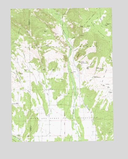
Ice Cave Peak, UT USGS Topographic Map
Click on map above to begin viewing in our Map Viewer.

This topographic map contains these locations and features:
Feature Name Type Latitude Longitude GNIS ID View Map
Bathtub TroughValleyN40.5666°W109.9674°1455175View Map
Bench SpringSpringN40.5685°W109.9077°1425423View Map
Big Tom HollowValleyN40.5508°W109.9193°1425567View Map
Birch SpringSpringN40.5521°W109.8884°1425620View Map
Bridger CanyonValleyN40.5930°W109.9285°1425961View Map
Buck RidgeRidgeN40.6211°W109.9740°1439234View Map
Bull PastureAreaN40.5533°W109.9446°1454693View Map
Cart HollowValleyN40.5327°W109.9957°1439490View Map
Cart Hollow SpringSpringN40.5053°W109.9924°1426366View Map
Coal Mine DrawValleyN40.6066°W109.9846°1426763View Map
Cottonwood SpringSpringN40.5633°W109.9865°1426946View Map
Cuch SpringSpringN40.5502°W109.8824°1427148View Map
East Cart Hollow ReservoirReservoirN40.5503°W109.9905°1455249View Map
Elkhorn Guard StationLocaleN40.5491°W109.9540°1427797View Map
Elkhorn TroughValleyN40.5447°W109.9596°1455258View Map
Farm Creek BridgeBridgeN40.5483°W109.9543°1450107View Map
Farm Creek CanalCanalN40.5269°W109.9568°1427884View Map
Farm Creek Grazing EnclosureLocaleN40.5838°W109.9885°1454735View Map
Henry Olsen DrawValleyN40.5516°W109.9846°1441711View Map
Hominy CreekStreamN40.5633°W109.9602°1441827View Map
Horricks SpringSpringN40.5904°W109.9573°1428820View Map
Ice Cave PeakSummitN40.6075°W109.9104°1428967View Map
Ice Cave SpringSpringN40.6074°W109.9066°1428968View Map
Lees HollowValleyN40.5677°W109.9104°1429523View Map
Loggers Cabin ParkFlatN40.6100°W109.8827°1429855View Map
Lower Big Tom Hollow SpringsSpringN40.5603°W109.8983°1429969View Map
Mosby MountainSummitN40.6075°W109.9104°1443610View Map
Murray SpringSpringN40.5457°W109.8799°1430612View Map
Paradise CreekStreamN40.6166°W109.9393°1444186View Map
Ralphs CanyonValleyN40.5850°W109.9207°1431561View Map
Rat SpringSpringN40.5531°W109.8846°1431584View Map
Red KnollSummitN40.5047°W109.9796°1431659View Map
Red Pine CanyonValleyN40.5713°W109.9207°1431679View Map
Red Pine SpringSpringN40.5744°W109.9172°1431685View Map
Reeds CemeteryCemeteryN40.5246°W109.9583°1431733View Map
Sand Point SpringSpringN40.5733°W109.9147°1432199View Map
Snake John SpringSpringN40.5665°W109.9828°1432586View Map
Sulphur SpringSpringN40.5672°W109.9504°1433048View Map
The HoleBasinN40.5908°W109.9913°1433337View Map
Upper Big Tom Hollow SpringSpringN40.5686°W109.8951°1433795View Map
Upper Cart Hollow SpringsSpringN40.5347°W109.9952°1433801View Map
WhiterocksSummitN40.5838°W109.9104°1434209View Map
Whiterocks CampgroundLocaleN40.6197°W109.9424°1455580View Map
Whiterocks CanalCanalN40.5136°W109.9002°1434211View Map
Wild Horse DrawValleyN40.5261°W109.9613°1447348View Map
Woodard SpringSpringN40.6042°W109.9595°1434453View Map

Note: Coordinates in the location and feature list above are referenced to NAD83 datum.


Copyright (C) 2008-2025 Ryan Niemi / Sunset Dynamics ... All Rights Reserved