TopoQuest Logo
Do you find TopoQuest useful?
Help keep TopoQuest running and adding new maps/features by donating!
Bitcoin:  19c7KJd3qBynnjoSw5npx9KScwjBe4ifkT
Litecoin:  LXs6TkuXGGXo1vDsWCkWVdjQX94eUKd6ui
Home View Maps Find Maps Find Places Resources & Links


Barnum, Wyoming Topographic Map

USGS Map Title: Barnum, WY
USGS Map MRC: 43106F8
DRG (GeoTIFF) Download: o43106f8.tif


Neighboring USGS Topographic Map Quads:


  Tabletop, WY  
43107G1
 

  Fraker Mountain, WY  
43106G8
 

  Mayoworth, WY  
43106G7
 

  Turk Springs, WY  
43107F1
 

  Barnum, WY  
43106F8
 

  Red Fork Powder River, WY  
43106F7
 

  Gordon Creek, WY  
43107E1
 

  Poker Butte, WY  
43106E8
 

  Hole-in-the-Wall, WY  
43106E7


Map MRC Location:

N44°
W107°
N44°
W106°
H8 H7 H6 H5 H4 H3 H2 H1
G8 G7 G6 G5 G4 G3 G2 G1
F8 F7 F6 F5 F4 F3 F2 F1
E8 E7 E6 E5 E4 E3 E2 E1
D8 D7 D6 D5 D4 D3 D2 D1
C8 C7 C6 C5 C4 C3 C2 C1
B8 B7 B6 B5 B4 B3 B2 B1
A8 A7 A6 A5 A4 A3 A2 A1
N43°
W107°
N43°
W106°

Barnum, WY USGS 1:24K Topographic Map Preview:
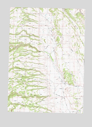
Barnum, WY USGS Topographic Map
Click on map above to begin viewing in our Map Viewer.

This topographic map contains these locations and features:
Feature Name Type Latitude Longitude GNIS ID View Map
A RidgeRidgeN43.7408°W106.9734°1584689View Map
BarnumPopulated PlaceN43.6641°W106.9095°1597214View Map
Barnum DitchCanalN43.6586°W106.9009°1585142View Map
Beaver Creek DitchCanalN43.6727°W106.9314°1585312View Map
Big Red DamDamN43.7166°W106.8839°1608324View Map
Big Red ReservoirReservoirN43.7170°W106.8839°1608325View Map
Blue CreekStreamN43.6589°W106.9062°1585672View Map
Blue Creek DitchCanalN43.6452°W106.9142°1585673View Map
Blue Creek RanchLocaleN43.6486°W106.9259°1585674View Map
Box Elder RidgeRidgeN43.7458°W106.9714°1585842View Map
Brock CampLocaleN43.7475°W106.9117°1585939View Map
Buckbrush ButteSummitN43.6397°W106.9409°1586029View Map
Cottonwood CreekStreamN43.7494°W106.8834°1587050View Map
D Cross RanchLocaleN43.6947°W106.9331°1587320View Map
Devoe CanyonValleyN43.6691°W106.9370°1587573View Map
Ferris RidgeRidgeN43.7244°W106.9714°1588434View Map
Freeman DitchCanalN43.6577°W106.8814°1588737View Map
Freeman Number 3 DamDamN43.6866°W106.8856°1606550View Map
Freeman Number 3 ReservoirReservoirN43.6866°W106.8856°1606551View Map
Graves DitchCanalN43.6755°W106.9170°1589081View Map
Graves RanchLocaleN43.6652°W106.9137°1589083View Map
Horse Pasture RidgeRidgeN43.6486°W106.9537°1589709View Map
Hunter DrawValleyN43.7461°W106.8839°1589814View Map
McCarthy Number 1 DamDamN43.6666°W106.8789°1606556View Map
McCarthy Reservoir Number 1ReservoirN43.6666°W106.8789°1606557View Map
Minecke DrawValleyN43.6591°W106.8889°1591636View Map
N H RidgeRidgeN43.6966°W106.9712°1591947View Map
Narrow RidgeRidgeN43.7361°W106.9692°1591958View Map
North RidgeRidgeN43.7308°W106.9709°1592265View Map
Poison Weed RidgeRidgeN43.7122°W106.9748°1592916View Map
Red DrawValleyN43.7072°W106.9267°1593281View Map
Red Fork Number Two MineMineN43.7500°W106.9381°1726525View Map
Road RidgeRidgeN43.7175°W106.9762°1593506View Map
Robins RidgeRidgeN43.6827°W106.9659°1593530View Map
Rowan SpringStreamN43.6452°W106.9981°1593687View Map
Sawmill V RidgeRidgeN43.6702°W106.9764°1593970View Map
Sheep CreekStreamN43.6300°W106.8806°1594194View Map
Telephone RidgeRidgeN43.6902°W106.9726°1595352View Map
Toll GapGapN43.7164°W106.9134°1595613View Map
West Fork Freeman DrawValleyN43.6936°W106.8926°1596192View Map
White Panther DitchCanalN43.7052°W106.9359°1596311View Map
Wide Divide RidgeRidgeN43.6583°W106.9587°1596347View Map
Winsor DitchCanalN43.6980°W106.9267°1596557View Map
Wolcott RanchLocaleN43.7383°W106.9412°1596572View Map

Note: Coordinates in the location and feature list above are referenced to NAD83 datum.


Copyright (C) 2008-2025 Ryan Niemi / Sunset Dynamics ... All Rights Reserved