TopoQuest Logo
Do you find TopoQuest useful?
Help keep TopoQuest running and adding new maps/features by donating!
Bitcoin:  19c7KJd3qBynnjoSw5npx9KScwjBe4ifkT
Litecoin:  LXs6TkuXGGXo1vDsWCkWVdjQX94eUKd6ui
Home View Maps Find Maps Find Places Resources & Links


Red Fork Powder River, Wyoming Topographic Map

USGS Map Title: Red Fork Powder River, WY
USGS Map MRC: 43106F7
DRG (GeoTIFF) Download: o43106f7.tif


Neighboring USGS Topographic Map Quads:


  Fraker Mountain, WY  
43106G8
 

  Mayoworth, WY  
43106G7
 

  Hibbard Draw, WY  
43106G6
 

  Barnum, WY  
43106F8
 

  Red Fork Powder River, WY  
43106F7
 

  Kaycee, WY  
43106F6
 

  Poker Butte, WY  
43106E8
 

  Hole-in-the-Wall, WY  
43106E7
 

  TTT Ranch, WY  
43106E6


Map MRC Location:

N44°
W107°
N44°
W106°
H8 H7 H6 H5 H4 H3 H2 H1
G8 G7 G6 G5 G4 G3 G2 G1
F8 F7 F6 F5 F4 F3 F2 F1
E8 E7 E6 E5 E4 E3 E2 E1
D8 D7 D6 D5 D4 D3 D2 D1
C8 C7 C6 C5 C4 C3 C2 C1
B8 B7 B6 B5 B4 B3 B2 B1
A8 A7 A6 A5 A4 A3 A2 A1
N43°
W107°
N43°
W106°

Red Fork Powder River, WY USGS 1:24K Topographic Map Preview:
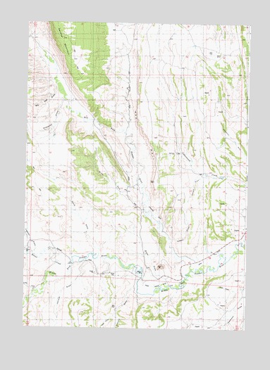
Red Fork Powder River, WY USGS Topographic Map
Click on map above to begin viewing in our Map Viewer.

This topographic map contains these locations and features:
Feature Name Type Latitude Longitude GNIS ID View Map
Arminto DrawValleyN43.6414°W106.8128°1584935View Map
Beaver CreekStreamN43.6511°W106.8478°1585308View Map
Big Red DrawValleyN43.7244°W106.8589°1585494View Map
Brock ForkStreamN43.6761°W106.8087°1585941View Map
Champion DrawValleyN43.7183°W106.8545°1586571View Map
Comstock DitchCanalN43.6719°W106.8023°1586923View Map
Cottonwood Creek MineMineN43.7236°W106.8006°1726520View Map
David Kinker DitchCanalN43.6427°W106.7978°1587360View Map
Davis DrawValleyN43.6550°W106.8331°1587368View Map
Embry DrawValleyN43.6608°W106.7909°1588284View Map
Freeman DrawValleyN43.6564°W106.8692°1588738View Map
Harlan RidgeRidgeN43.6336°W106.8081°2420851View Map
Hole-in-the-Wall LakeLakeN43.6666°W106.8339°1597163View Map
Johnson DrawValleyN43.6522°W106.8409°1590170View Map
Kaycee Bentonite Corporation Number Seventy-six MineMineN43.7041°W106.7503°1746270View Map
Kaycee Bentonite Corporation Number Seventy-three MineMineN43.7025°W106.7501°1746267View Map
Red Fork Number One MineMineN43.6786°W106.8051°1726524View Map
Red Fork Powder RiverStreamN43.6491°W106.7812°1593287View Map
Red Wall Number 1CliffN43.7144°W106.8131°1605439View Map
Red Wall Number 2CliffN43.6950°W106.8273°1605440View Map
Rim Rock DrawValleyN43.6875°W106.7762°1593469View Map
Smith DrawValleyN43.6441°W106.7953°1594480View Map
Stubbs DrawValleyN43.6408°W106.8689°1595131View Map
West Prong Arminto DrawValleyN43.6305°W106.8234°1596235View Map

Note: Coordinates in the location and feature list above are referenced to NAD83 datum.


Copyright (C) 2008-2025 Ryan Niemi / Sunset Dynamics ... All Rights Reserved