TopoQuest Logo
Do you find TopoQuest useful?
Help keep TopoQuest running and adding new maps/features by donating!
Bitcoin:  19c7KJd3qBynnjoSw5npx9KScwjBe4ifkT
Litecoin:  LXs6TkuXGGXo1vDsWCkWVdjQX94eUKd6ui
Home View Maps Find Maps Find Places Resources & Links


Lake West, Oklahoma Topographic Map

USGS Map Title: Lake West, OK
USGS Map MRC: 33095H8
DRG (GeoTIFF) Download: o33095h8.tif


Neighboring USGS Topographic Map Quads:


  Bennington North, OK  
34096A1
 

  Boswell SW, OK  
34095A8
 

  Boswell, OK  
34095A7
 

  Bennington South, OK  
33096H1
 

  Lake West, OK  
33095H8
 

  New Oberlin, OK  
33095H7
 

  Telephone, TX  
33096G1
 

  Monkstown, TX  
33095G8
 

  Direct, TX  
33095G7


Map MRC Location:

N34°
W96°
N34°
W95°
H8 H7 H6 H5 H4 H3 H2 H1
G8 G7 G6 G5 G4 G3 G2 G1
F8 F7 F6 F5 F4 F3 F2 F1
E8 E7 E6 E5 E4 E3 E2 E1
D8 D7 D6 D5 D4 D3 D2 D1
C8 C7 C6 C5 C4 C3 C2 C1
B8 B7 B6 B5 B4 B3 B2 B1
A8 A7 A6 A5 A4 A3 A2 A1
N33°
W96°
N33°
W95°

Lake West, OK USGS 1:24K Topographic Map Preview:
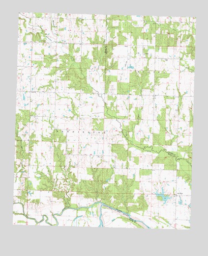
Lake West, OK USGS Topographic Map
Click on map above to begin viewing in our Map Viewer.

This topographic map contains these locations and features:
Feature Name Type Latitude Longitude GNIS ID View Map
Belvin SchoolSchoolN33.9504°W95.9025°1089996View Map
Blue RiverStreamN33.8868°W95.9469°1090292View Map
Dill CemeteryCemeteryN33.9868°W95.9099°2723905View Map
Frazier CreekStreamN33.9276°W95.9178°1093024View Map
Good Springs CemeteryCemeteryN33.9755°W95.9117°2723907View Map
Good Springs ChurchChurchN33.9784°W95.9116°1093246View Map
Jackson CemeteryCemeteryN33.9505°W95.9908°2724016View Map
Jackson SchoolSchoolN33.9545°W95.9822°1094164View Map
Lake WestPopulated PlaceN33.8959°W95.8855°1100118View Map
Lake West SchoolSchoolN33.8957°W95.8822°1094481View Map
Lewis Eastwood DamDamN33.9168°W95.9086°1754406View Map
Lewis Eastwood ReservoirReservoirN33.9168°W95.9086°1754407View Map
Oknoname 013005 DamDamN33.9468°W95.9969°1757887View Map
Oknoname 013005 ReservoirReservoirN33.9468°W95.9969°1757888View Map
Oknoname 013006 DamDamN33.8901°W95.8903°1757859View Map
Oknoname 013006 ReservoirReservoirN33.8901°W95.8903°1757860View Map
Oknoname 013009 DamDamN33.9418°W95.9969°1756054View Map
Oknoname 013009 ReservoirReservoirN33.9418°W95.9969°1756055View Map
Oknoname 013021 DamDamN33.8918°W95.8803°1757879View Map
Oknoname 013021 ReservoirReservoirN33.8918°W95.8803°1757880View Map
Patsy SpringSpringN33.8993°W95.9403°1096465View Map
Shady Grove SchoolSchoolN33.9126°W95.9891°1097944View Map
Siby SpringSpringN33.9015°W95.9608°1098032View Map
Slash CreekStreamN33.9595°W95.9416°1098110View Map
Teal LakeReservoirN33.9368°W95.9886°1756087View Map
Teal Lake DamDamN33.9368°W95.9886°1756086View Map
Whitesand CreekStreamN33.9837°W95.9700°1099734View Map
Wilson SchoolSchoolN33.9976°W95.9114°1099898View Map
Winters CreekStreamN33.9995°W95.9991°1099924View Map

Note: Coordinates in the location and feature list above are referenced to NAD83 datum.


Copyright (C) 2008-2024 Ryan Niemi / Sunset Dynamics ... All Rights Reserved