TopoQuest Logo
Do you find TopoQuest useful?
Help keep TopoQuest running and adding new maps/features by donating!
Bitcoin:  19c7KJd3qBynnjoSw5npx9KScwjBe4ifkT
Litecoin:  LXs6TkuXGGXo1vDsWCkWVdjQX94eUKd6ui
Home View Maps Find Maps Find Places Resources & Links


Bennington South, Oklahoma Topographic Map

USGS Map Title: Bennington South, OK
USGS Map MRC: 33096H1
DRG (GeoTIFF) Download: o33096h1.tif


Neighboring USGS Topographic Map Quads:


  Bokchito, OK  
34096A2
 

  Bennington North, OK  
34096A1
 

  Boswell SW, OK  
34095A8
 

  Blue, OK  
33096H2
 

  Bennington South, OK  
33096H1
 

  Lake West, OK  
33095H8
 

  Yuba, OK  
33096G2
 

  Telephone, TX  
33096G1
 

  Monkstown, TX  
33095G8


Map MRC Location:

N34°
W97°
N34°
W96°
H8 H7 H6 H5 H4 H3 H2 H1
G8 G7 G6 G5 G4 G3 G2 G1
F8 F7 F6 F5 F4 F3 F2 F1
E8 E7 E6 E5 E4 E3 E2 E1
D8 D7 D6 D5 D4 D3 D2 D1
C8 C7 C6 C5 C4 C3 C2 C1
B8 B7 B6 B5 B4 B3 B2 B1
A8 A7 A6 A5 A4 A3 A2 A1
N33°
W97°
N33°
W96°

Bennington South, OK USGS 1:24K Topographic Map Preview:
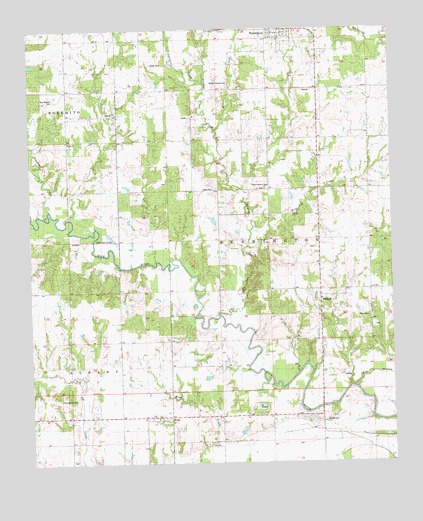
Bennington South, OK USGS Topographic Map
Click on map above to begin viewing in our Map Viewer.

This topographic map contains these locations and features:
Feature Name Type Latitude Longitude GNIS ID View Map
Arnett ChurchChurchN33.9679°W96.1091°1089708View Map
Beames SchoolLocaleN33.9762°W96.0919°1089898View Map
Blue Branch CemeteryCemeteryN33.9800°W96.1164°1090268View Map
Bokchito CreekStreamN33.9482°W96.1155°1090372View Map
Cherokee LakeLakeN33.9407°W96.0953°1091242View Map
Chishoktak ChurchChurchN33.9170°W96.0080°1091311View Map
Gregory LakeReservoirN33.9901°W96.1019°1755702View Map
Gregory Lake DamDamN33.9901°W96.1019°1755701View Map
Julius CemeteryCemeteryN33.9536°W96.0624°1094271View Map
Labors CemeteryCemeteryN33.9902°W96.0827°1094449View Map
Manning SchoolLocaleN33.9465°W96.0408°1095118View Map
McGee CreekStreamN33.9707°W96.0591°1095236View Map
McGee Springs CemeteryCemeteryN33.9846°W96.0561°1095238View Map
McIntire LakeReservoirN33.8784°W96.1003°1755710View Map
McIntire Lake DamDamN33.8784°W96.1003°1755709View Map
Midland ChurchChurchN33.9226°W96.0239°1095371View Map
Page LakeReservoirN33.9868°W96.0019°1755700View Map
Page Lake DamDamN33.9868°W96.0019°1755699View Map
Red BranchStreamN33.8970°W96.0147°1097085View Map
Sassafras CreekStreamN33.9854°W96.0628°1097845View Map
Smith-LeePopulated PlaceN33.8870°W96.0247°1098142View Map
Spring Hill CemeteryCemeteryN33.8937°W96.1152°1098436View Map
Sulphur CreekStreamN33.9179°W96.0589°1098626View Map
Sulphur Creek ChurchChurchN33.9548°W96.0419°1098629View Map
Sulphur Springs ChurchChurchN33.9548°W96.0430°1738080View Map
Township of BenningtonCivilN33.9362°W96.0086°1824707View Map
WadePopulated PlaceN33.8890°W96.0761°1099282View Map
Wade Volunteer Fire DepartmentBuildingN33.8880°W96.0847°2657165View Map
Wolf CreekStreamN33.9379°W96.0489°1099941View Map

Note: Coordinates in the location and feature list above are referenced to NAD83 datum.


Copyright (C) 2008-2025 Ryan Niemi / Sunset Dynamics ... All Rights Reserved