TopoQuest Logo
Do you find TopoQuest useful?
Help keep TopoQuest running and adding new maps/features by donating!
Bitcoin:  19c7KJd3qBynnjoSw5npx9KScwjBe4ifkT
Litecoin:  LXs6TkuXGGXo1vDsWCkWVdjQX94eUKd6ui
Home View Maps Find Maps Find Places Resources & Links


Lamartine, Arkansas Topographic Map

USGS Map Title: Lamartine, AR
USGS Map MRC: 33093D3
DRG (GeoTIFF) Download: o33093d3.tif


Neighboring USGS Topographic Map Quads:


  Bodcaw, AR  
33093E4
 

  Willisville, AR  
33093E3
 

  Waterloo, AR  
33093E2
 

  Falcon, AR  
33093D4
 

  Lamartine, AR  
33093D3
 

  Magnolia NW, AR  
33093D2
 

  Buckner, AR  
33093C4
 

  Waldo, AR  
33093C3
 

  Magnolia, AR  
33093C2


Map MRC Location:

N34°
W94°
N34°
W93°
H8 H7 H6 H5 H4 H3 H2 H1
G8 G7 G6 G5 G4 G3 G2 G1
F8 F7 F6 F5 F4 F3 F2 F1
E8 E7 E6 E5 E4 E3 E2 E1
D8 D7 D6 D5 D4 D3 D2 D1
C8 C7 C6 C5 C4 C3 C2 C1
B8 B7 B6 B5 B4 B3 B2 B1
A8 A7 A6 A5 A4 A3 A2 A1
N33°
W94°
N33°
W93°

Lamartine, AR USGS 1:24K Topographic Map Preview:
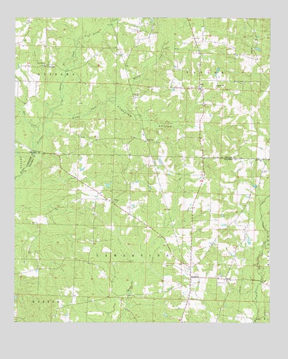
Lamartine, AR USGS Topographic Map
Click on map above to begin viewing in our Map Viewer.

This topographic map contains these locations and features:
Feature Name Type Latitude Longitude GNIS ID View Map
Beech CreekPopulated PlaceN33.3996°W93.3391°59940View Map
BethelPopulated PlaceN33.4243°W93.3277°56929View Map
Bethel ChurchChurchN33.4251°W93.3268°59941View Map
BrightPopulated PlaceN33.4196°W93.3191°59942View Map
Brushy CreekStreamN33.4573°W93.3602°47058View Map
Brushy CreekStreamN33.4921°W93.3424°47070View Map
Columbia CemeteryCemeteryN33.3848°W93.2904°47937View Map
Coopers School (historical)SchoolN33.4243°W93.2877°59944View Map
Cypress CreekStreamN33.4573°W93.3602°48302View Map
DeltaPopulated PlaceN33.4718°W93.2849°56988View Map
Forest Grove School (historical)SchoolN33.3990°W93.2885°59945View Map
Hickory Hill Church (historical)ChurchN33.4432°W93.3532°59947View Map
Kendrick ChapelChurchN33.4737°W93.2632°50806View Map
KZHE-FM (Stamps)TowerN33.4762°W93.2732°85431View Map
LamartinePopulated PlaceN33.3932°W93.2888°58041View Map
Mill CreekStreamN33.4443°W93.3654°52006View Map
New Hope ChurchChurchN33.4810°W93.3610°52670View Map
Nichols School (historical)SchoolN33.4998°W93.3688°60380View Map
Pleasant Hill ChurchChurchN33.4723°W93.2766°53566View Map
Pleasant Hill School (historical)SchoolN33.4726°W93.2766°60383View Map
Rocky Mound School (historical)SchoolN33.4001°W93.3427°59951View Map
SandersPopulated PlaceN33.4807°W93.3574°58582View Map
Shady Grove ChurchChurchN33.4418°W93.2535°54702View Map
ShilohPopulated PlaceN33.3929°W93.2713°58614View Map
Shiloh CemeteryCemeteryN33.3910°W93.2710°54772View Map
Shiloh ChurchChurchN33.3923°W93.2713°59953View Map
StocktonPopulated PlaceN33.4493°W93.3104°58692View Map
Stockton BottomFlatN33.4585°W93.3132°55238View Map
Township of Lamartine (historical)CivilN33.3807°W93.2960°59958View Map
Township of WaldoCivilN33.3815°W93.3148°63754View Map
Union Chapel (historical)ChurchN33.4051°W93.3588°59954View Map
Waldrep CemeteryCemeteryN33.4684°W93.3149°55947View Map
Waldrep CreekStreamN33.4657°W93.3302°55948View Map
Willisville Oil FieldOilfieldN33.4971°W93.3118°78777View Map
Willow Spring School (historical)SchoolN33.4065°W93.2888°59955View Map

Note: Coordinates in the location and feature list above are referenced to NAD83 datum.


Copyright (C) 2008-2024 Ryan Niemi / Sunset Dynamics ... All Rights Reserved