TopoQuest Logo
Do you find TopoQuest useful?
Help keep TopoQuest running and adding new maps/features by donating!
Bitcoin:  19c7KJd3qBynnjoSw5npx9KScwjBe4ifkT
Litecoin:  LXs6TkuXGGXo1vDsWCkWVdjQX94eUKd6ui
Home View Maps Find Maps Find Places Resources & Links


Magnolia NW, Arkansas Topographic Map

USGS Map Title: Magnolia NW, AR
USGS Map MRC: 33093D2
DRG (GeoTIFF) Download: o33093d2.tif


Neighboring USGS Topographic Map Quads:


  Willisville, AR  
33093E3
 

  Waterloo, AR  
33093E2
 

  Troy, AR  
33093E1
 

  Lamartine, AR  
33093D3
 

  Magnolia NW, AR  
33093D2
 

  Stephens, AR  
33093D1
 

  Waldo, AR  
33093C3
 

  Magnolia, AR  
33093C2
 

  Village, AR  
33093C1


Map MRC Location:

N34°
W94°
N34°
W93°
H8 H7 H6 H5 H4 H3 H2 H1
G8 G7 G6 G5 G4 G3 G2 G1
F8 F7 F6 F5 F4 F3 F2 F1
E8 E7 E6 E5 E4 E3 E2 E1
D8 D7 D6 D5 D4 D3 D2 D1
C8 C7 C6 C5 C4 C3 C2 C1
B8 B7 B6 B5 B4 B3 B2 B1
A8 A7 A6 A5 A4 A3 A2 A1
N33°
W94°
N33°
W93°

Magnolia NW, AR USGS 1:24K Topographic Map Preview:
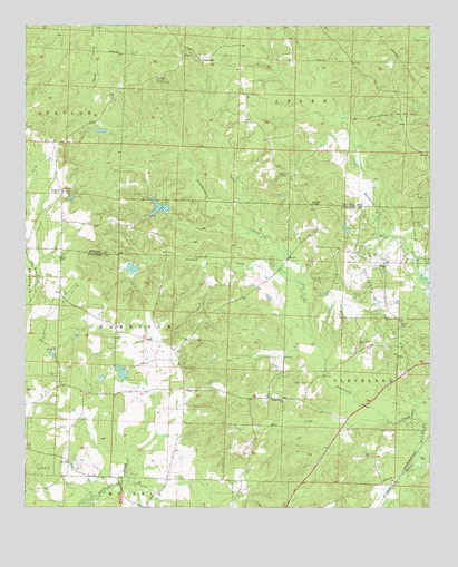
Magnolia NW, AR USGS Topographic Map
Click on map above to begin viewing in our Map Viewer.

This topographic map contains these locations and features:
Feature Name Type Latitude Longitude GNIS ID View Map
Arkansas Noname 62 DamDamN33.4518°W93.2068°80225View Map
Blake CreekStreamN33.4457°W93.1766°60334View Map
College HillPopulated PlaceN33.4060°W93.2010°76652View Map
College Hill Oil and Gas FieldOilfieldN33.4154°W93.2318°59943View Map
Corinth ChurchChurchN33.4385°W93.1391°48045View Map
Crooked CreekStreamN33.4346°W93.1660°48170View Map
DavidsonPopulated PlaceN33.4571°W93.2391°60349View Map
Davidson ChurchChurchN33.4568°W93.2385°48370View Map
Dupriest LakeReservoirN33.4528°W93.2089°80226View Map
Early View ChurchChurchN33.4176°W93.1477°48739View Map
Edwards ChapelChurchN33.4537°W93.1613°48823View Map
Fincher LakeReservoirN33.4371°W93.2172°80228View Map
Fincher Lake DamDamN33.4368°W93.2152°80227View Map
Gatlin CemeteryCemeteryN33.4223°W93.1343°49359View Map
GlenvillePopulated PlaceN33.4915°W93.1957°57823View Map
Glenville Lookout TowerTowerN33.4862°W93.2091°82436View Map
Harpers School (historical)SchoolN33.4368°W93.2079°59946View Map
Lake BradshawReservoirN33.4727°W93.2268°80224View Map
Lake Bradshaw DamDamN33.4735°W93.2252°80223View Map
Mill CreekStreamN33.3979°W93.1391°51986View Map
Milner (historical)Populated PlaceN33.3810°W93.1396°59949View Map
Miner CemeteryCemeteryN33.4073°W93.1629°52088View Map
Mount Zion School (historical)SchoolN33.4812°W93.1343°60401View Map
North Stephens Oil and Gas FieldOilfieldN33.4757°W93.1354°52842View Map
Pine Grove School (historical)SchoolN33.4198°W93.2218°59948View Map
Pretty BranchStreamN33.3962°W93.1491°59950View Map
Saint MatthewsPopulated PlaceN33.4035°W93.1752°59952View Map
Saint Matthews ChurchChurchN33.4026°W93.1699°78258View Map
Spring BranchStreamN33.3996°W93.1296°78429View Map
Tick Hill CemeteryCemeteryN33.4612°W93.1688°55567View Map
Township of Harrison (historical)CivilN33.4168°W93.2057°59957View Map
Township of McNeilCivilN33.3814°W93.1697°63750View Map
Union Grove School (historical)SchoolN33.4479°W93.2393°60396View Map
Watts CemeteryCemeteryN33.4571°W93.2377°56116View Map

Note: Coordinates in the location and feature list above are referenced to NAD83 datum.


Copyright (C) 2008-2024 Ryan Niemi / Sunset Dynamics ... All Rights Reserved