TopoQuest Logo
Do you find TopoQuest useful?
Help keep TopoQuest running and adding new maps/features by donating!
Bitcoin:  19c7KJd3qBynnjoSw5npx9KScwjBe4ifkT
Litecoin:  LXs6TkuXGGXo1vDsWCkWVdjQX94eUKd6ui
Home View Maps Find Maps Find Places Resources & Links


Magnolia, Arkansas Topographic Map

USGS Map Title: Magnolia, AR
USGS Map MRC: 33093C2
DRG (GeoTIFF) Download: o33093c2.tif


Neighboring USGS Topographic Map Quads:


  Lamartine, AR  
33093D3
 

  Magnolia NW, AR  
33093D2
 

  Stephens, AR  
33093D1
 

  Waldo, AR  
33093C3
 

  Magnolia, AR  
33093C2
 

  Village, AR  
33093C1
 

  Macedonia, AR  
33093B3
 

  Calhoun, AR  
33093B2
 

  Spotville, AR  
33093B1


Map MRC Location:

N34°
W94°
N34°
W93°
H8 H7 H6 H5 H4 H3 H2 H1
G8 G7 G6 G5 G4 G3 G2 G1
F8 F7 F6 F5 F4 F3 F2 F1
E8 E7 E6 E5 E4 E3 E2 E1
D8 D7 D6 D5 D4 D3 D2 D1
C8 C7 C6 C5 C4 C3 C2 C1
B8 B7 B6 B5 B4 B3 B2 B1
A8 A7 A6 A5 A4 A3 A2 A1
N33°
W94°
N33°
W93°

Magnolia, AR USGS 1:24K Topographic Map Preview:
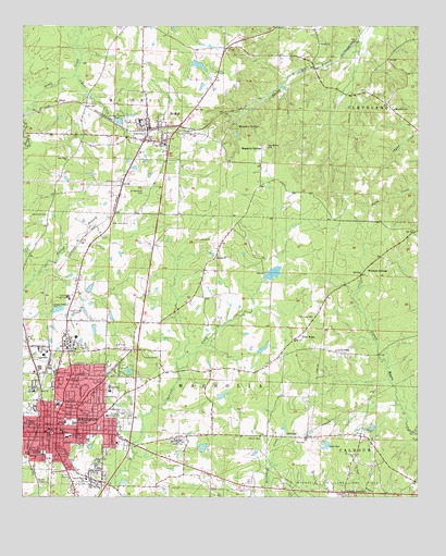
Magnolia, AR USGS Topographic Map
Click on map above to begin viewing in our Map Viewer.

This topographic map contains these locations and features:
Feature Name Type Latitude Longitude GNIS ID View Map
Asa G Garrett Memorial LibraryBuildingN33.2674°W93.2391°60206View Map
Asbury United Methodist ChurchChurchN33.2860°W93.2232°60199View Map
Bearden LakeReservoirN33.3648°W93.1946°80443View Map
Bearden Lake DamDamN33.3651°W93.1968°80442View Map
Calhoun Heights SchoolSchoolN33.2549°W93.2299°47280View Map
Calhoun JunctionPopulated PlaceN33.2512°W93.1482°57493View Map
Central Baptist ChurchChurchN33.2682°W93.2418°60209View Map
Central Elementary SchoolSchoolN33.2696°W93.2361°83409View Map
City of MagnoliaCivilN33.2777°W93.2261°2404998View Map
City of McNeilCivilN33.3482°W93.2085°2405054View Map
Columbia County Ambulance ServiceBuildingN33.2648°W93.2380°2119029View Map
Columbia County CourthouseBuildingN33.2671°W93.2410°60207View Map
Columbia County JailBuildingN33.2660°W93.2416°84378View Map
Columbia High SchoolSchoolN33.2621°W93.2438°47938View Map
Columbia Shopping CenterLocaleN33.2662°W93.2357°60204View Map
East Side Elementary SchoolSchoolN33.2718°W93.2232°2039364View Map
Eastside ParkParkN33.2724°W93.2193°48788View Map
Eastside SchoolSchoolN33.2715°W93.2232°76841View Map
EmonPopulated PlaceN33.3546°W93.2379°57721View Map
First Baptist ChurchChurchN33.2674°W93.2374°60205View Map
First United Methodist ChurchChurchN33.2674°W93.2427°60210View Map
Free HopePopulated PlaceN33.2918°W93.1641°57020View Map
Free Hope CemeteryCemeteryN33.2982°W93.1579°49231View Map
Free Hope ChurchChurchN33.2915°W93.1641°59904View Map
Grace Christian AcademySchoolN33.2829°W93.2029°60196View Map
Green CemeteryCemeteryN33.3746°W93.2182°1964791View Map
Green CreekStreamN33.3518°W93.2499°49630View Map
Greers ChurchChurchN33.3135°W93.1888°49671View Map
Greers School (historical)SchoolN33.2996°W93.1932°59908View Map
Hartsfield CemeteryCemeteryN33.3248°W93.2427°49924View Map
Hospital ParkParkN33.2751°W93.2385°60202View Map
Jimmy Jones Community CenterBuildingN33.2646°W93.2252°60197View Map
JohnstonPopulated PlaceN33.2660°W93.1671°57995View Map
KVMA-AM (Magnolia)TowerN33.2998°W93.2327°85111View Map
KVMA-FM (Magnolia)TowerN33.2998°W93.2327°85219View Map
Lake SueReservoirN33.2639°W93.1543°80447View Map
Lake Sue DamDamN33.2635°W93.1535°80446View Map
Logans Chapel (historical)ChurchN33.2837°W93.1804°59907View Map
Logoly State ParkParkN33.3479°W93.1849°59910View Map
Macedonia ChurchChurchN33.3532°W93.1327°51561View Map
Magnesia SpringsSpringN33.3482°W93.1821°51602View Map
Magnesia SpringsPopulated PlaceN33.3426°W93.1743°58113View Map
MagnoliaPopulated PlaceN33.2671°W93.2393°77578View Map
Magnolia CemeteryCemeteryN33.2646°W93.2451°2107471View Map
Magnolia High SchoolSchoolN33.2788°W93.2225°60198View Map
Magnolia Housing AuthorityBuildingN33.2651°W93.2266°2118892View Map
Magnolia Junior High SchoolSchoolN33.2695°W93.2339°60203View Map
Magnolia Memorial ParkCemeteryN33.2657°W93.2004°51612View Map
Magnolia Police DepartmentBuildingN33.2686°W93.2389°2118894View Map
Magnolia Post OfficePost OfficeN33.2679°W93.2379°83917View Map
Magnolia Regional Medical CenterHospitalN33.2742°W93.2388°60200View Map
Magnolia Volunteer Fire DepartmentBuildingN33.2686°W93.2389°2116755View Map
McNeilPopulated PlaceN33.3479°W93.2099°58155View Map
McNeil Elementary SchoolSchoolN33.3437°W93.2052°59912View Map
McNeil Fire StationBuildingN33.3483°W93.2103°2116784View Map
Mcneil High SchoolSchoolN33.3498°W93.2135°2039365View Map
McNeil High SchoolSchoolN33.3498°W93.2132°59913View Map
Milner School (historical)SchoolN33.3707°W93.1563°59906View Map
Mulerider StadiumParkN33.2960°W93.2354°60201View Map
New Bethel CemeteryCemeteryN33.3432°W93.1732°52617View Map
New Bethel Church (historical)ChurchN33.3432°W93.1741°59909View Map
New Hope CemeteryCemeteryN33.3223°W93.2221°52659View Map
New Hope ChurchChurchN33.3396°W93.2360°52669View Map
O'Rear CreekStreamN33.3621°W93.2338°77868View Map
Pittman LakeReservoirN33.2770°W93.1871°80445View Map
Pittman Lake DamDamN33.2768°W93.1885°80444View Map
Saint Matthew Church (historical)ChurchN33.3312°W93.2107°59911View Map
Saint Matthews CemeteryCemeteryN33.3312°W93.2118°54426View Map
Sand Ridge School (historical)SchoolN33.2885°W93.1466°59905View Map
Sanders School (historical)SchoolN33.3096°W93.2318°59914View Map
Southern Arkansas UniversitySchoolN33.2898°W93.2360°78419View Map
Southern Arkansas University Police DepartmentBuildingN33.2932°W93.2372°2118895View Map
Southside ParkParkN33.2535°W93.2299°55046View Map
Township of Cleveland (historical)CivilN33.3710°W93.1293°59956View Map
Vernon ChapelChurchN33.2890°W93.1507°55899View Map
Victory ChurchChurchN33.3704°W93.1560°55908View Map
Warnock SpringsSpringN33.3097°W93.1431°60195View Map
Warnock SpringsPopulated PlaceN33.3101°W93.1418°58831View Map

Note: Coordinates in the location and feature list above are referenced to NAD83 datum.


Copyright (C) 2008-2024 Ryan Niemi / Sunset Dynamics ... All Rights Reserved