TopoQuest Logo
Do you find TopoQuest useful?
Help keep TopoQuest running and adding new maps/features by donating!
Bitcoin:  19c7KJd3qBynnjoSw5npx9KScwjBe4ifkT
Litecoin:  LXs6TkuXGGXo1vDsWCkWVdjQX94eUKd6ui
Home View Maps Find Maps Find Places Resources & Links


Lampe, Missouri Topographic Map

USGS Map Title: Lampe, MO
USGS Map MRC: 36093E4
DRG (GeoTIFF) Download: o36093e4.tif


Neighboring USGS Topographic Map Quads:


  Cape Fair, MO  
36093F5
 

  Reeds Spring, MO  
36093F4
 

  Garber, MO  
36093F3
 

  Viola, MO  
36093E5
 

  Lampe, MO  
36093E4
 

  Table Rock Dam, MO  
36093E3
 

  Grandview, AR  
36093D5
 

  Blue Eye, AR  
36093D4
 

  Denver, AR  
36093D3


Map MRC Location:

N37°
W94°
N37°
W93°
H8 H7 H6 H5 H4 H3 H2 H1
G8 G7 G6 G5 G4 G3 G2 G1
F8 F7 F6 F5 F4 F3 F2 F1
E8 E7 E6 E5 E4 E3 E2 E1
D8 D7 D6 D5 D4 D3 D2 D1
C8 C7 C6 C5 C4 C3 C2 C1
B8 B7 B6 B5 B4 B3 B2 B1
A8 A7 A6 A5 A4 A3 A2 A1
N36°
W94°
N36°
W93°

Lampe, MO USGS 1:24K Topographic Map Preview:
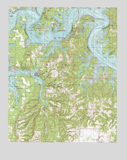
Lampe, MO USGS Topographic Map
Click on map above to begin viewing in our Map Viewer.

This topographic map contains these locations and features:
Feature Name Type Latitude Longitude GNIS ID View Map
BaxterPopulated PlaceN36.5662°W93.4921°753057View Map
Black Oak RidgeRidgeN36.5642°W93.4549°748888View Map
Blowing Springs HollowValleyN36.5526°W93.4599°748918View Map
Blue Eye Public SchoolsSchoolN36.5048°W93.3952°753062View Map
Blue Eye School (historical)SchoolN36.5120°W93.4038°732923View Map
Bobwhite CoveBayN36.5894°W93.3960°2770923View Map
Bread Tray MountainSummitN36.5806°W93.4794°749009View Map
Cedar BluffCliffN36.6051°W93.4269°749274View Map
Cedar Spring HollowValleyN36.5656°W93.4796°749311View Map
Company HollowValleyN36.5540°W93.4602°749438View Map
Coney IslandPopulated PlaceN36.5931°W93.3971°1669614View Map
Cow CreekStreamN36.5751°W93.3896°749502View Map
Cow Creek ParkParkN36.5665°W93.3930°753130View Map
Cow Creek Public Use AreaParkN36.5667°W93.3944°753059View Map
Dogwood CreekStreamN36.5242°W93.4550°48558View Map
Dorcas (historical)Populated PlaceN36.5981°W93.4638°755656View Map
Evans BluffCliffN36.6020°W93.4805°749861View Map
Evans Cemetery (historical)CemeteryN36.6148°W93.4744°749862View Map
Fanncomb HollowValleyN36.5362°W93.4546°749901View Map
Fisher CreekStreamN36.6220°W93.4252°749924View Map
Goar HollowValleyN36.6101°W93.4288°750056View Map
Gospel Lighthouse ChurchChurchN36.5195°W93.4891°753060View Map
Great Bend of White River (historical)BendN36.5924°W93.4637°2646765View Map
Hammer Cemetery (historical)CemeteryN36.6067°W93.4319°750205View Map
Henderson HollowValleyN36.5276°W93.4652°750290View Map
Highview ChurchChurchN36.5448°W93.4285°750322View Map
Hobbs HollowValleyN36.5320°W93.4641°750344View Map
HomerPopulated PlaceN36.5209°W93.3960°755654View Map
Hoot Owl HollowValleyN36.6015°W93.4452°750384View Map
Horn Cemetery (historical)CemeteryN36.6006°W93.4721°750392View Map
Indian Hills Community ChurchChurchN36.6056°W93.4596°753053View Map
Jannings HollowValleyN36.6101°W93.4696°750501View Map
Joe Bald ParkParkN36.6070°W93.4702°753128View Map
Jones School (historical)SchoolN36.5934°W93.4835°732919View Map
Kanakuk-Kanakom Church CampLocaleN36.5509°W93.4855°753058View Map
Kennel BranchStreamN36.6056°W93.3988°750587View Map
Kimberling AirportAirportN36.6090°W93.4431°758762View Map
Kimberling BridgeBridgeN36.6237°W93.4216°754414View Map
Kimberling CemeteryCemeteryN36.6120°W93.4199°750604View Map
Kimberling Park (historical)ParkN36.6203°W93.4226°2646550View Map
LampePopulated PlaceN36.5637°W93.4380°750646View Map
Little Cow CreekStreamN36.5812°W93.4007°750755View Map
Little Indian CreekStreamN36.5628°W93.4963°51286View Map
Little Joe BaldSummitN36.6217°W93.4555°750776View Map
Little Mill CreekStreamN36.5920°W93.4457°750784View Map
Little Wolfpen HollowValleyN36.6153°W93.4930°748546View Map
Logslide BluffCliffN36.5862°W93.4074°750825View Map
MarmarosPopulated PlaceN36.6192°W93.4541°755655View Map
McCollough School (historical)SchoolN36.5487°W93.4580°732920View Map
Mill CreekStreamN36.5767°W93.4360°751058View Map
Mill Creek ParkParkN36.5942°W93.4405°753129View Map
Mill Creek Public Use AreaParkN36.5937°W93.4413°753054View Map
Mobley Bluff (historical)CliffN36.6034°W93.4391°751136View Map
Naked Joe BaldSummitN36.6184°W93.4594°751253View Map
Old Elm Tree ChurchChurchN36.5542°W93.4380°753930View Map
Philibert BluffCliffN36.6225°W93.4908°751572View Map
Philibert Cemetery (historical)CemeteryN36.6170°W93.4649°751573View Map
Pine Crest CemeteryCemeteryN36.5967°W93.4216°753055View Map
Pitts Cemetery (historical)CemeteryN36.5967°W93.4527°751647View Map
Poplar HollowValleyN36.5665°W93.4702°751713View Map
Porter HollowValleyN36.5384°W93.4549°751715View Map
Powell Mill HollowValleyN36.6076°W93.4788°751737View Map
RadicalPopulated PlaceN36.6228°W93.4191°732921View Map
Rhodes CemeteryCemeteryN36.5053°W93.4177°751860View Map
Rice CemeteryCemeteryN36.5823°W93.3896°751862View Map
Right ProngStreamN36.5626°W93.4744°751876View Map
Schooner CreekStreamN36.6212°W93.4055°752055View Map
Slane ChapelChurchN36.6084°W93.3796°753056View Map
Slane School (historical)SchoolN36.6084°W93.3799°732922View Map
Southern Stone County Fire Protection District Station 14BuildingN36.6104°W93.4572°2620560View Map
Southern Stone County Fire Protection District Station 15BuildingN36.5246°W93.4790°2620559View Map
Southern Stone County Fire Protection District Station 3BuildingN36.5651°W93.4402°2620609View Map
Southern Stone County Fire Protection District Station 4BuildingN36.5128°W93.3973°2620509View Map
Stillhouse HollowValleyN36.6012°W93.4316°752365View Map
Sunrise School (historical)SchoolN36.5400°W93.4547°2646467View Map
Thomas Camp (historical)LocaleN36.6228°W93.4257°2646461View Map
Thomas Cemetery (historical)CemeteryN36.6128°W93.4321°752526View Map
Tibbetts School (historical)SchoolN36.5442°W93.4074°2646466View Map
Town of Blue EyeCivilN36.5149°W93.3830°2396595View Map
Township of Pine ACivilN36.5402°W93.3789°767432View Map
Township of Pine BCivilN36.5806°W93.4480°767433View Map
Trace HollowValleyN36.5470°W93.4927°752573View Map
Village of Coney IslandCivilN36.5932°W93.3971°2398615View Map
Waldon HollowValleyN36.5426°W93.4635°752728View Map
Whiterock BluffCliffN36.6070°W93.3869°752868View Map
Whites BranchStreamN36.6148°W93.3888°752869View Map
Wildcat HollowValleyN36.5392°W93.4666°752887View Map
Wolfpen HollowValleyN36.6190°W93.4919°752959View Map
Yates Cemetery (historical)CemeteryN36.5981°W93.4402°752996View Map
Yocum HollowValleyN36.5556°W93.4613°753002View Map

Note: Coordinates in the location and feature list above are referenced to NAD83 datum.


Copyright (C) 2008-2025 Ryan Niemi / Sunset Dynamics ... All Rights Reserved