TopoQuest Logo
Do you find TopoQuest useful?
Help keep TopoQuest running and adding new maps/features by donating!
Bitcoin:  19c7KJd3qBynnjoSw5npx9KScwjBe4ifkT
Litecoin:  LXs6TkuXGGXo1vDsWCkWVdjQX94eUKd6ui
Home View Maps Find Maps Find Places Resources & Links


Grandview, Arkansas Topographic Map

USGS Map Title: Grandview, AR
USGS Map MRC: 36093D5
DRG (GeoTIFF) Download: o36093d5.tif


Neighboring USGS Topographic Map Quads:


  Golden, MO  
36093E6
 

  Viola, MO  
36093E5
 

  Lampe, MO  
36093E4
 

  Eureka Springs, AR  
36093D6
 

  Grandview, AR  
36093D5
 

  Blue Eye, AR  
36093D4
 

  Rockhouse, AR  
36093C6
 

  Berryville, AR  
36093C5
 

  Green Forest, AR  
36093C4


Map MRC Location:

N37°
W94°
N37°
W93°
H8 H7 H6 H5 H4 H3 H2 H1
G8 G7 G6 G5 G4 G3 G2 G1
F8 F7 F6 F5 F4 F3 F2 F1
E8 E7 E6 E5 E4 E3 E2 E1
D8 D7 D6 D5 D4 D3 D2 D1
C8 C7 C6 C5 C4 C3 C2 C1
B8 B7 B6 B5 B4 B3 B2 B1
A8 A7 A6 A5 A4 A3 A2 A1
N36°
W94°
N36°
W93°

Grandview, AR USGS 1:24K Topographic Map Preview:
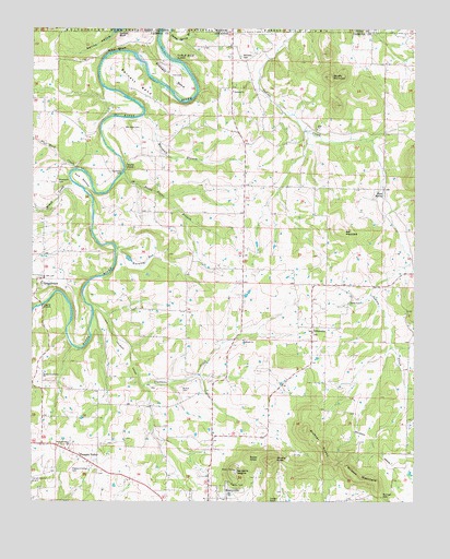
Grandview, AR USGS Topographic Map
Click on map above to begin viewing in our Map Viewer.

This topographic map contains these locations and features:
Feature Name Type Latitude Longitude GNIS ID View Map
Ant MountainSummitN36.4470°W93.5246°57270View Map
Antioch Church of God of the Apostolic FaithChurchN36.4834°W93.5602°76182View Map
Barnett BendBendN36.4853°W93.5910°46109View Map
Berkes Community ChurchChurchN36.4090°W93.6213°46399View Map
Blackjack CemeteryCemeteryN36.4178°W93.5555°1959666View Map
Blackjack ChurchChurchN36.4176°W93.5563°76370View Map
Brother KnobsSummitN36.3901°W93.5296°57449View Map
Brush CreekStreamN36.4587°W93.6113°47047View Map
Brushy KnobsSummitN36.3856°W93.5474°57455View Map
Brushy MountainSummitN36.4876°W93.5285°47088View Map
Bunch CemeteryCemeteryN36.4053°W93.5763°47182View Map
Carr CemeteryCemeteryN36.4881°W93.5805°47478View Map
Carroll County AirportAirportN36.3831°W93.6212°83641View Map
Clabber CreekStreamN36.4265°W93.6060°76616View Map
Duncan GapGapN36.3762°W93.5107°48702View Map
Flat Rock CreekStreamN36.4628°W93.6113°49118View Map
Freeman (historical)Populated PlaceN36.4098°W93.5732°1968164View Map
Fuller LakeReservoirN36.4392°W93.5936°79665View Map
Fuller Lake DamDamN36.4401°W93.5935°79664View Map
Gallion BluffCliffN36.4987°W93.5974°49314View Map
Gallion HollowValleyN36.4995°W93.5988°49315View Map
GrandviewPopulated PlaceN36.4340°W93.6213°49549View Map
Grandview Post Office (historical)Post OfficeN36.4340°W93.6210°84441View Map
Gum BottomBendN36.4606°W93.6094°49706View Map
Herd SpringSpringN36.3981°W93.5182°69225View Map
HighPopulated PlaceN36.4709°W93.5364°69226View Map
High CemeteryCemeteryN36.4734°W93.5316°1959673View Map
High ChurchChurchN36.4737°W93.5324°50117View Map
High Post Office (historical)Post OfficeN36.4705°W93.5367°2100914View Map
Indian Creek (historical)Populated PlaceN36.4324°W93.5135°2572522View Map
Jones CemeteryCemeteryN36.4284°W93.5205°50730View Map
KSCC-FM (Berryville)TowerN36.3828°W93.5585°85163View Map
Marshall BranchStreamN36.4776°W93.5891°51692View Map
Marshall CemeteryCemeteryN36.4740°W93.5905°51695View Map
Moreland CemeteryCemeteryN36.4598°W93.6171°52181View Map
Pine BluffCliffN36.4948°W93.5982°53404View Map
Pleasant ValleyPopulated PlaceN36.3870°W93.6099°58401View Map
Pleasant Valley CemeteryCemeteryN36.3823°W93.6116°53607View Map
Pleasant Valley ChurchChurchN36.3895°W93.6132°53619View Map
Polo (historical)Populated PlaceN36.4795°W93.5502°69236View Map
Saunders HeightsSummitN36.3828°W93.5585°58590View Map
Sister KnobSummitN36.3865°W93.5544°78371View Map
Stewart BendBendN36.4865°W93.5791°55214View Map
Stony PointCliffN36.4637°W93.5946°55250View Map
Stony Point BranchStreamN36.4620°W93.5957°55252View Map
Summers FordCrossingN36.4626°W93.5957°58711View Map
Township of PoloCivilN36.4475°W93.5449°66908View Map
UrbanettePopulated PlaceN36.4198°W93.5335°57217View Map
Urbanette School (historical)SchoolN36.4209°W93.5332°69244View Map
Waxweed RunStreamN36.4423°W93.5982°56122View Map
Wilkins MountainSummitN36.3812°W93.5191°58892View Map
Williams CemeteryCemeteryN36.4920°W93.5560°56395View Map
Wood SpringSpringN36.4562°W93.5102°56512View Map

Note: Coordinates in the location and feature list above are referenced to NAD83 datum.


Copyright (C) 2008-2024 Ryan Niemi / Sunset Dynamics ... All Rights Reserved