TopoQuest Logo
Do you find TopoQuest useful?
Help keep TopoQuest running and adding new maps/features by donating!
Bitcoin:  19c7KJd3qBynnjoSw5npx9KScwjBe4ifkT
Litecoin:  LXs6TkuXGGXo1vDsWCkWVdjQX94eUKd6ui
Home View Maps Find Maps Find Places Resources & Links


Viola, Missouri Topographic Map

USGS Map Title: Viola, MO
USGS Map MRC: 36093E5
DRG (GeoTIFF) Download: o36093e5.tif


Neighboring USGS Topographic Map Quads:


  Shell Knob, MO  
36093F6
 

  Cape Fair, MO  
36093F5
 

  Reeds Spring, MO  
36093F4
 

  Golden, MO  
36093E6
 

  Viola, MO  
36093E5
 

  Lampe, MO  
36093E4
 

  Eureka Springs, AR  
36093D6
 

  Grandview, AR  
36093D5
 

  Blue Eye, AR  
36093D4


Map MRC Location:

N37°
W94°
N37°
W93°
H8 H7 H6 H5 H4 H3 H2 H1
G8 G7 G6 G5 G4 G3 G2 G1
F8 F7 F6 F5 F4 F3 F2 F1
E8 E7 E6 E5 E4 E3 E2 E1
D8 D7 D6 D5 D4 D3 D2 D1
C8 C7 C6 C5 C4 C3 C2 C1
B8 B7 B6 B5 B4 B3 B2 B1
A8 A7 A6 A5 A4 A3 A2 A1
N36°
W94°
N36°
W93°

Viola, MO USGS 1:24K Topographic Map Preview:
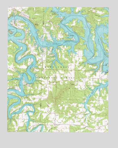
Viola, MO USGS Topographic Map
Click on map above to begin viewing in our Map Viewer.

This topographic map contains these locations and features:
Feature Name Type Latitude Longitude GNIS ID View Map
Allen Ford (historical)CrossingN36.5345°W93.6238°753913View Map
Arnold Ford (historical)LocaleN36.5898°W93.5257°753922View Map
Arrow PointPopulated PlaceN36.5448°W93.6194°1669610View Map
Basin HollowValleyN36.6005°W93.5725°2764377View Map
Baxter Public Use AreaParkN36.5670°W93.5016°748715View Map
Beasley Ford (historical)LocaleN36.6045°W93.5024°753920View Map
Big BayBayN36.6245°W93.5677°748816View Map
Big Bay Public Use AreaParkN36.6184°W93.5674°748817View Map
Big Creek Ford (historical)LocaleN36.6151°W93.5507°753918View Map
Big Indian Public Use AreaParkN36.5598°W93.5007°748841View Map
Big Joe BaldSummitN36.5598°W93.5007°748842View Map
Bristow HollowValleyN36.5546°W93.5879°2764403View Map
Campbell Point Public Use AreaParkN36.5959°W93.5505°749186View Map
Carr LanePopulated PlaceN36.5078°W93.5657°749221View Map
Carr Lane ChurchChurchN36.5167°W93.5652°749222View Map
Carr Lane SubofficeBuildingN36.5076°W93.5857°753928View Map
Carr SchoolSchoolN36.5167°W93.5652°753910View Map
Carters Bottom (historical)BendN36.5542°W93.5942°2764402View Map
Cassville Ranger DistrictForestN36.6237°W93.6238°754437View Map
Cedar HollowValleyN36.5701°W93.5263°749302View Map
Center Prong Mill CreekStreamN36.5644°W93.5647°2764407View Map
Central Crossing Fire Protection District StationBuildingN36.5537°W93.5770°2621348View Map
Central Crossing Fire Protection District Station 2BuildingN36.6071°W93.6119°2620602View Map
Central Crossing Fire Protection District Station 4BuildingN36.6096°W93.5813°2620939View Map
Denny Spring BranchStreamN36.5013°W93.5819°48474View Map
Discovery Bay at Norwalk LandingAirportN36.6209°W93.5399°2770284View Map
East Prong Mill CreekStreamN36.5657°W93.5554°2764408View Map
Field CemeteryCemeteryN36.6109°W93.5721°749915View Map
Field SchoolLocaleN36.6109°W93.5724°753917View Map
Gamblers GulchValleyN36.5639°W93.5875°2764401View Map
Greens HollowValleyN36.5367°W93.6038°750151View Map
Hardman HollowValleyN36.5868°W93.5860°2764398View Map
Hendrickson School (historical)LocaleN36.5826°W93.5360°753924View Map
Indian CreekStreamN36.5195°W93.5224°50497View Map
Indian Creek Ford (historical)LocaleN36.5798°W93.5063°753923View Map
Kings RiverStreamN36.5951°W93.6230°77407View Map
Kings River Golf CourseLocaleN36.5245°W93.6133°2678232View Map
Kings River Public Use AreaParkN36.5517°W93.6107°750620View Map
Lawrence Ford (historical)LocaleN36.5381°W93.5196°753926View Map
Leonard Cemetery (historical)CemeteryN36.5878°W93.5756°2764399View Map
Lost HillIslandN36.5959°W93.6152°750867View Map
Lucy Smith HollowValleyN36.5512°W93.5872°2764405View Map
McCandles School (historical)SchoolN36.5123°W93.6116°753915View Map
McCullough ChurchChurchN36.5467°W93.5207°750991View Map
McCullough School (historical)LocaleN36.5459°W93.5082°753925View Map
McGuire CemeteryCemeteryN36.5317°W93.5985°750999View Map
McGuire School (historical)SchoolN36.5317°W93.5985°753914View Map
Mill CreekStreamN36.5626°W93.5687°751057View Map
Mill CreekStreamN36.5970°W93.6216°751074View Map
NauvooPopulated PlaceN36.5040°W93.5121°751266View Map
Nauvoo SchoolSchoolN36.5106°W93.5080°732918View Map
Owens SchoolLocaleN36.6145°W93.5177°753919View Map
Perkins HollowValleyN36.5895°W93.5019°751548View Map
Pilot KnobSummitN36.5473°W93.5460°751591View Map
Prentiss Ford (historical)CrossingN36.5953°W93.6210°753911View Map
Prentiss Ford (historical)CrossingN36.5126°W93.5980°753916View Map
Quail CoveBayN36.5928°W93.5681°2783991View Map
Ray Ford (historical)LocaleN36.5965°W93.5138°753921View Map
Rock Spring HollowValleyN36.5573°W93.6088°751928View Map
Schreiner Ferry (historical)CrossingN36.6151°W93.6166°753927View Map
Shell KnobSummitN36.6076°W93.5894°752105View Map
Shell Knob CampgroundLocaleN36.6120°W93.5955°752106View Map
Shell Knob Census Designated PlaceCensusN36.6105°W93.6041°2393231View Map
Sweetwater CreekStreamN36.5534°W93.6094°752464View Map
The Peninsula AirportAirportN36.5671°W93.5091°2679386View Map
Township of WilliamsCivilN36.5438°W93.5337°767440View Map
Village of Arrow PointCivilN36.5441°W93.6224°2397991View Map
ViolaPopulated PlaceN36.5731°W93.5821°752720View Map
Viola CemeteryCemeteryN36.5778°W93.5893°752721View Map
Viola Ford (historical)CrossingN36.5662°W93.5923°2764400View Map
Viola Public Use AreaParkN36.5617°W93.5949°752722View Map
Viola School (historical)SchoolN36.5876°W93.6002°753912View Map

Note: Coordinates in the location and feature list above are referenced to NAD83 datum.


Copyright (C) 2008-2025 Ryan Niemi / Sunset Dynamics ... All Rights Reserved