TopoQuest Logo
Do you find TopoQuest useful?
Help keep TopoQuest running and adding new maps/features by donating!
Bitcoin:  19c7KJd3qBynnjoSw5npx9KScwjBe4ifkT
Litecoin:  LXs6TkuXGGXo1vDsWCkWVdjQX94eUKd6ui
Home View Maps Find Maps Find Places Resources & Links


Fairfax, Missouri Topographic Map

USGS Map Title: Fairfax, MO
USGS Map MRC: 40095C4
DRG (GeoTIFF) Download: o40095c4.tif


Neighboring USGS Topographic Map Quads:


  Rock Port, MO  
40095D5
 

  Tarkio West, MO  
40095D4
 

  Tarkio East, MO  
40095D3
 

  Langdon, MO  
40095C5
 

  Fairfax, MO  
40095C4
 

  Tarkio SE, MO  
40095C3
 

  Barada, NE  
40095B5
 

  Corning, MO  
40095B4
 

  Craig, MO  
40095B3


Map MRC Location:

N41°
W96°
N41°
W95°
H8 H7 H6 H5 H4 H3 H2 H1
G8 G7 G6 G5 G4 G3 G2 G1
F8 F7 F6 F5 F4 F3 F2 F1
E8 E7 E6 E5 E4 E3 E2 E1
D8 D7 D6 D5 D4 D3 D2 D1
C8 C7 C6 C5 C4 C3 C2 C1
B8 B7 B6 B5 B4 B3 B2 B1
A8 A7 A6 A5 A4 A3 A2 A1
N40°
W96°
N40°
W95°

Fairfax, MO USGS 1:24K Topographic Map Preview:
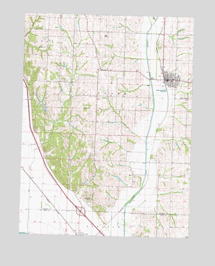
Fairfax, MO USGS Topographic Map
Click on map above to begin viewing in our Map Viewer.

This topographic map contains these locations and features:
Feature Name Type Latitude Longitude GNIS ID View Map
Angel HollowValleyN40.2736°W95.4572°713296View Map
Angel School (historical)SchoolN40.2864°W95.4443°730050View Map
Beck CemeteryCemeteryN40.3222°W95.4544°743277View Map
Bush CemeteryCemeteryN40.3558°W95.4861°754120View Map
City of FairfaxCivilN40.3392°W95.3920°2394731View Map
Community Hospital - FairfaxHospitalN40.3495°W95.3948°2655030View Map
Corning CemeteryCemeteryN40.2692°W95.4503°716328View Map
Cow BranchStreamN40.3725°W95.4033°716404View Map
English Grove CemeteryCemeteryN40.3439°W95.4439°2681283View Map
English Grove ChurchChurchN40.3433°W95.4430°717597View Map
FairfaxPopulated PlaceN40.3386°W95.3933°717732View Map
Fairfax Elementary SchoolSchoolN40.3386°W95.3905°2545238View Map
Fairfax High SchoolSchoolN40.3396°W95.3895°2545253View Map
Fairfax Police DepartmentBuildingN40.3389°W95.3933°2752285View Map
Fairfax Post OfficePost OfficeN40.3385°W95.3931°2782560View Map
Fairfax Volunteer Fire DepartmentBuildingN40.3394°W95.3964°2621747View Map
Graves Lake DamDamN40.2833°W95.4286°761926View Map
Happy Hollow LakeReservoirN40.3246°W95.4858°761664View Map
Irish Grove School (historical)SchoolN40.3283°W95.4497°720162View Map
Lowell Pierce DamDamN40.3200°W95.4819°761663View Map
McCoy-Waits Lake DamDamN40.3450°W95.4686°761923View Map
Mill CreekStreamN40.2505°W95.4941°722339View Map
MiltonPopulated PlaceN40.2847°W95.4172°741071View Map
Milton School (historical)SchoolN40.2831°W95.4178°747045View Map
Mount Hope CemeteryCemeteryN40.2697°W95.4505°743278View Map
Mount Pleasant School (historical)SchoolN40.3733°W95.4878°722879View Map
Pleasant Ridge CemeteryCemeteryN40.3289°W95.3761°724583View Map
Pleasant Ridge School (historical)SchoolN40.3206°W95.3791°724601View Map
Prairie Flower School (historical)SchoolN40.3656°W95.4383°724844View Map
Rupes Grove ChurchChurchN40.3728°W95.4511°740016View Map
Steele AirportAirportN40.3651°W95.4393°758673View Map
Township of ClarkCivilN40.3197°W95.4356°766232View Map
Valley View School (historical)SchoolN40.3300°W95.4964°728107View Map

Note: Coordinates in the location and feature list above are referenced to NAD83 datum.


Copyright (C) 2008-2024 Ryan Niemi / Sunset Dynamics ... All Rights Reserved