TopoQuest Logo
Do you find TopoQuest useful?
Help keep TopoQuest running and adding new maps/features by donating!
Bitcoin:  19c7KJd3qBynnjoSw5npx9KScwjBe4ifkT
Litecoin:  LXs6TkuXGGXo1vDsWCkWVdjQX94eUKd6ui
Home View Maps Find Maps Find Places Resources & Links


Norman, Arkansas Topographic Map

USGS Map Title: Norman, AR
USGS Map MRC: 34093D6
DRG (GeoTIFF) Download: o34093d6.tif


Neighboring USGS Topographic Map Quads:


  Oden, AR  
34093E7
 

  Mount Ida, AR  
34093E6
 

  Reed Mountain, AR  
34093E5
 

  Polk Creek Mountain, AR  
34093D7
 

  Norman, AR  
34093D6
 

  Caddo Gap, AR  
34093D5
 

  Langley, AR  
34093C7
 

  Lodi, AR  
34093C6
 

  Glenwood, AR  
34093C5


Map MRC Location:

N35°
W94°
N35°
W93°
H8 H7 H6 H5 H4 H3 H2 H1
G8 G7 G6 G5 G4 G3 G2 G1
F8 F7 F6 F5 F4 F3 F2 F1
E8 E7 E6 E5 E4 E3 E2 E1
D8 D7 D6 D5 D4 D3 D2 D1
C8 C7 C6 C5 C4 C3 C2 C1
B8 B7 B6 B5 B4 B3 B2 B1
A8 A7 A6 A5 A4 A3 A2 A1
N34°
W94°
N34°
W93°

Norman, AR USGS 1:24K Topographic Map Preview:
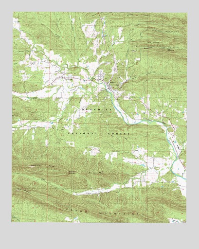
Norman, AR USGS Topographic Map
Click on map above to begin viewing in our Map Viewer.

This topographic map contains these locations and features:
Feature Name Type Latitude Longitude GNIS ID View Map
Barr Memorial Presbyterian ChurchChurchN34.4548°W93.6794°63445View Map
Beck MountainSummitN34.4823°W93.6491°70592View Map
Beech CreekStreamN34.4509°W93.7499°76279View Map
Black SpringsPopulated PlaceN34.4612°W93.7127°70701View Map
Black Springs CemeteryCemeteryN34.4640°W93.7138°63454View Map
Black Springs First Baptist ChurchChurchN34.4629°W93.7135°63455View Map
Black Springs School (historical)SchoolN34.4607°W93.7127°63456View Map
Caddo Hills Elementary SchoolSchoolN34.4207°W93.6315°63463View Map
Caddo Hills High SchoolSchoolN34.4193°W93.6308°83401View Map
Caddo MountainsRidgeN34.3865°W93.7210°70951View Map
Caddo MountainsRangeN34.3865°W93.7210°66973View Map
Caddo Valley Academy (historical)SchoolN34.4562°W93.6794°63464View Map
Cedar Bluff School (historical)SchoolN34.4551°W93.6816°63466View Map
Chapel CemeteryCemeteryN34.4484°W93.6355°76587View Map
Collier CreekStreamN34.4134°W93.6319°71199View Map
Crystal Recreation AreaParkN34.4795°W93.6382°71306View Map
Ferguson CemeteryCemeteryN34.4734°W93.6724°63485View Map
Fodderstack MountainSummitN34.4045°W93.7096°71649View Map
Fodderstack RangeRidgeN34.4084°W93.7385°71652View Map
Gap MountainSummitN34.3945°W93.7441°71724View Map
Hall BranchStreamN34.4251°W93.6394°64911View Map
Hamilton CreekStreamN34.4679°W93.7027°71887View Map
Harvey BranchStreamN34.4715°W93.7021°77139View Map
Hewing BranchStreamN34.4773°W93.7360°77168View Map
Huddleston CreekStreamN34.4595°W93.6677°72108View Map
Hyatt CreekStreamN34.4070°W93.6516°72137View Map
Irby CemeteryCemeteryN34.4523°W93.7396°63515View Map
Lick CreekStreamN34.4576°W93.6885°72336View Map
ManfredPopulated PlaceN34.4079°W93.6485°72546View Map
Manfred Colored School (historical)SchoolN34.3993°W93.6488°63536View Map
Manfred School (historical)SchoolN34.4062°W93.6488°63537View Map
Middleton-Crooks CemeteryCemeteryN34.4315°W93.7321°63541View Map
Mill CreekStreamN34.4079°W93.6366°72657View Map
Montgomery CemeteryCemeteryN34.4579°W93.6838°63545View Map
Montgomery CreekStreamN34.4665°W93.6677°72714View Map
Mount IdaSummitN34.4957°W93.6410°72141View Map
Nealy BranchStreamN34.4670°W93.7102°77795View Map
NormanPopulated PlaceN34.4551°W93.6802°77857View Map
Norman Assembly of God ChurchChurchN34.4601°W93.6877°63567View Map
Norman First Baptist ChurchChurchN34.4568°W93.6810°63568View Map
Norman United Methodist ChurchChurchN34.4576°W93.6816°63569View Map
Norman Volunteer Fire DepartmentBuildingN34.4588°W93.6850°2116859View Map
Oklahoma School (historical)SchoolN34.4557°W93.7266°63580View Map
Pleasant Valley Baptist Church (historical)ChurchN34.3982°W93.6521°63597View Map
Pleasant Valley School (historical)SchoolN34.3982°W93.6521°63598View Map
Polk CreekStreamN34.4554°W93.7016°73151View Map
Red Oak RangeRidgeN34.4043°W93.6874°73257View Map
Robbins CemeteryCemeteryN34.4159°W93.6391°63607View Map
Rowton CemeteryCemeteryN34.4645°W93.6369°63613View Map
Sardis School (historical)SchoolN34.4295°W93.7160°63615View Map
Sloan BranchStreamN34.4520°W93.6932°78378View Map
Smith CreekStreamN34.4012°W93.6255°73617View Map
Smoky HollowValleyN34.4520°W93.6791°73629View Map
Swindle CreekStreamN34.4609°W93.6930°73802View Map
Town of Black SpringsCivilN34.4604°W93.7111°2405274View Map
Town of NormanCivilN34.4585°W93.6792°2406998View Map
Township of Gap (historical)CivilN34.3862°W93.6335°68886View Map
Township of Womble (historical)CivilN34.4584°W93.6682°68896View Map
Tweedle-Vaught CemeteryCemeteryN34.3959°W93.6616°63637View Map
Waco School (historical)SchoolN34.4465°W93.7091°63643View Map
Waco School CemeteryCemeteryN34.4462°W93.7091°63644View Map
Williams Ranch AirportAirportN34.3759°W93.6326°83651View Map
Yellow Jacket School (historical)SchoolN34.4729°W93.6888°63654View Map

Note: Coordinates in the location and feature list above are referenced to NAD83 datum.


Copyright (C) 2008-2024 Ryan Niemi / Sunset Dynamics ... All Rights Reserved