TopoQuest Logo
Do you find TopoQuest useful?
Help keep TopoQuest running and adding new maps/features by donating!
Bitcoin:  19c7KJd3qBynnjoSw5npx9KScwjBe4ifkT
Litecoin:  LXs6TkuXGGXo1vDsWCkWVdjQX94eUKd6ui
Home View Maps Find Maps Find Places Resources & Links


Narrows Dam, Arkansas Topographic Map

USGS Map Title: Narrows Dam, AR
USGS Map MRC: 34093B6
DRG (GeoTIFF) Download: o34093b6.tif


Neighboring USGS Topographic Map Quads:


  Langley, AR  
34093C7
 

  Lodi, AR  
34093C6
 

  Glenwood, AR  
34093C5
 

  Center Point NE, AR  
34093B7
 

  Narrows Dam, AR  
34093B6
 

  Murfreesboro NE, AR  
34093B5
 

  Nathan, AR  
34093A7
 

  Murfreesboro, AR  
34093A6
 

  Delight, AR  
34093A5


Map MRC Location:

N35°
W94°
N35°
W93°
H8 H7 H6 H5 H4 H3 H2 H1
G8 G7 G6 G5 G4 G3 G2 G1
F8 F7 F6 F5 F4 F3 F2 F1
E8 E7 E6 E5 E4 E3 E2 E1
D8 D7 D6 D5 D4 D3 D2 D1
C8 C7 C6 C5 C4 C3 C2 C1
B8 B7 B6 B5 B4 B3 B2 B1
A8 A7 A6 A5 A4 A3 A2 A1
N34°
W94°
N34°
W93°

Narrows Dam, AR USGS 1:24K Topographic Map Preview:
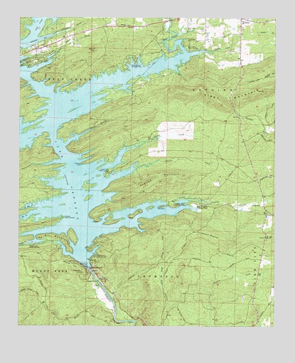
Narrows Dam, AR USGS Topographic Map
Click on map above to begin viewing in our Map Viewer.

This topographic map contains these locations and features:
Feature Name Type Latitude Longitude GNIS ID View Map
Abner (historical)Populated PlaceN34.1834°W93.7107°64593View Map
Beacon HillSummitN34.1512°W93.7255°46184View Map
Beacon Hill Picnic AreaLocaleN34.1490°W93.7205°46185View Map
Bear CreekStreamN34.2365°W93.6696°70553View Map
Bear Creek CemeteryCemeteryN34.2459°W93.6688°46218View Map
Bear Creek Public Use AreaParkN34.2373°W93.6646°76269View Map
Bethlehem Missionary Baptist ChurchChurchN34.2468°W93.6421°64601View Map
Chimney RockPillarN34.1909°W93.7199°47744View Map
Cowhide Cove Public Use AreaParkN34.1745°W93.6688°76695View Map
Cowhide CreekStreamN34.1759°W93.6674°48123View Map
Cummings CemeteryCemeteryN34.2407°W93.6685°48260View Map
DaisyPopulated PlaceN34.2373°W93.7421°48329View Map
Daisy CreekStreamN34.2359°W93.7327°48330View Map
Daisy State ParkParkN34.2326°W93.7427°48332View Map
Daisy Volunteer Fire DepartmentBuildingN34.2371°W93.7409°2116336View Map
Dynamite HillSummitN34.1515°W93.7116°57691View Map
Funderburk MountainSummitN34.1629°W93.6588°57779View Map
Helbig (historical)Populated PlaceN34.1371°W93.7366°64617View Map
Hicks CemeteryCemeteryN34.1743°W93.6321°50085View Map
Hinds BluffCliffN34.1268°W93.7024°50140View Map
Kirby CemeteryCemeteryN34.2465°W93.6435°64620View Map
Kirby Elementary SchoolSchoolN34.2483°W93.6408°64621View Map
Kirby High SchoolSchoolN34.2484°W93.6402°64622View Map
Kirby Landing Public Use AreaParkN34.2318°W93.6938°77412View Map
Kirby Lookout TowerTowerN34.1612°W93.6280°82466View Map
Kirby Post OfficePost OfficeN34.2497°W93.6423°84270View Map
Kirby Volunteer Fire StationBuildingN34.2476°W93.6416°2116667View Map
Lake Greeson Nursery PondReservoirN34.1588°W93.7453°81018View Map
Lake Greeson Nursery Pond DamDamN34.1734°W93.6669°81017View Map
Laurel CreekStreamN34.1970°W93.6971°50999View Map
Laurel Creek Public Use AreaParkN34.1871°W93.7069°77455View Map
Midway Missionary Baptist ChurchChurchN34.2470°W93.6991°77655View Map
Mill MountainSummitN34.1593°W93.7274°58182View Map
Narrows DamDamN34.1485°W93.7156°75798View Map
Narrows Dam Public Use AreaParkN34.1540°W93.7130°77790View Map
North Hog CreekStreamN34.1737°W93.7410°52830View Map
Parker CreekStreamN34.1587°W93.7466°53190View Map
Parker Creek Public Use AreaParkN34.1582°W93.7427°77953View Map
Pike CountyCivilN34.1635°W93.6563°69173View Map
Pikeville Public Use AreaParkN34.1693°W93.7294°77997View Map
Pleasant Grove Primitive Baptist ChurchChurchN34.2459°W93.6421°64640View Map
Ponder CreekStreamN34.2370°W93.6607°53683View Map
Riverside Picnic AreaParkN34.1440°W93.7110°54054View Map
Rough BranchStreamN34.2046°W93.7155°54230View Map
Round TopSummitN34.2373°W93.7149°58546View Map
School CreekStreamN34.2437°W93.7341°54619View Map
Skelton CreekStreamN34.1896°W93.6952°54888View Map
Skelton MountainSummitN34.1862°W93.6802°58631View Map
South Hog CreekStreamN34.1715°W93.7402°78411View Map
Stanley (historical)Populated PlaceN34.1368°W93.6352°64649View Map
Town of DaisyCivilN34.2349°W93.7406°2406349View Map
Township of Self CreekCivilN34.2403°W93.7414°68969View Map

Note: Coordinates in the location and feature list above are referenced to NAD83 datum.


Copyright (C) 2008-2024 Ryan Niemi / Sunset Dynamics ... All Rights Reserved