TopoQuest Logo
Do you find TopoQuest useful?
Help keep TopoQuest running and adding new maps/features by donating!
Bitcoin:  19c7KJd3qBynnjoSw5npx9KScwjBe4ifkT
Litecoin:  LXs6TkuXGGXo1vDsWCkWVdjQX94eUKd6ui
Home View Maps Find Maps Find Places Resources & Links


Larose, Louisiana Topographic Map

USGS Map Title: Larose, LA
USGS Map MRC: 29090E4
DRG (GeoTIFF) Download: o29090e4.tif


Neighboring USGS Topographic Map Quads:


  Lockport, LA  
29090F5
 

  Gheens, LA  
29090F4
 

  Catahoula Bay, LA  
29090F3
 

  Bourg, LA  
29090E5
 

  Larose, LA  
29090E4
 

  Cut Off, LA  
29090E3
 

  Montegut, LA  
29090D5
 

  Lake Bully Camp, LA  
29090D4
 

  Golden Meadow, LA  
29090D3


Map MRC Location:

N30°
W91°
N30°
W90°
H8 H7 H6 H5 H4 H3 H2 H1
G8 G7 G6 G5 G4 G3 G2 G1
F8 F7 F6 F5 F4 F3 F2 F1
E8 E7 E6 E5 E4 E3 E2 E1
D8 D7 D6 D5 D4 D3 D2 D1
C8 C7 C6 C5 C4 C3 C2 C1
B8 B7 B6 B5 B4 B3 B2 B1
A8 A7 A6 A5 A4 A3 A2 A1
N29°
W91°
N29°
W90°

Larose, LA USGS 1:24K Topographic Map Preview:
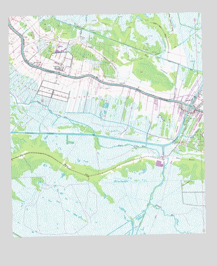
Larose, LA USGS Topographic Map
Click on map above to begin viewing in our Map Viewer.

This topographic map contains these locations and features:
Feature Name Type Latitude Longitude GNIS ID View Map
Bayou CoquilleGutN29.6174°W90.4520°532539View Map
Bayou L'Eau BleuBayN29.5434°W90.4013°532647View Map
Bayou ManuelGutN29.5402°W90.3765°532682View Map
Bayou PortugueseGutN29.5935°W90.4031°532740View Map
Canal BlueCanalN29.5616°W90.3865°533680View Map
Canal Tisamond ForetCanalN29.6135°W90.3798°533702View Map
Forty Arpent CanalCanalN29.6208°W90.4643°560782View Map
Grand Bois Gas FieldOilfieldN29.5280°W90.4904°557824View Map
Holy Rosary Catholic SchoolSchoolN29.5717°W90.3809°557828View Map
Hospital BayouLakeN29.5554°W90.3829°535822View Map
JayPopulated PlaceN29.5952°W90.4684°540634View Map
KBAU-FM (Galliano)TowerN29.5427°W90.4081°1633057View Map
KCIL-FM (Houma)TowerN29.5949°W90.3962°1633061View Map
Lafourche Fire District 3 East Larose StationBuildingN29.5709°W90.3793°2691645View Map
Lafourche ParishCivilN29.5003°W90.4026°558065View Map
Lafourche Parish Fire District 3 Larose Volunteer Fire Department North StationBuildingN29.5709°W90.3902°2691649View Map
Lafourche Parish Library Larose BranchBuildingN29.5746°W90.3766°2603102View Map
LarosePopulated PlaceN29.5724°W90.3817°554997View Map
Larose Census Designated PlaceCensusN29.5669°W90.3751°2403220View Map
Larose Post OfficePost OfficeN29.5713°W90.3801°1632194View Map
Lockport Volunteer Fire Department 308 StationBuildingN29.6229°W90.4998°2691621View Map
Lockport Volunteer Fire Department Valentine StationBuildingN29.5880°W90.4441°2691618View Map
LudevinePopulated PlaceN29.5855°W90.4276°555194View Map
Middle BayouGutN29.6033°W90.4420°537050View Map
NorahPopulated PlaceN29.6141°W90.4912°543531View Map
North Larose Elementary SchoolSchoolN29.5723°W90.3962°2493349View Map
Our Lady of the Rosary Catholic ChurchChurchN29.5724°W90.3814°2602554View Map
Parish Governing Authority District 10 (historical)CivilN29.5563°W90.4776°1929784View Map
Parish Governing Authority District 7CivilN29.5759°W90.4728°1930193View Map
Pointe Aux Chenes State Wildlife Management AreaParkN29.5008°W90.3759°1958619View Map
Seventh District SchoolSchoolN29.5983°W90.4845°539260View Map
ValentinePopulated PlaceN29.5947°W90.4673°543751View Map
Ward NineCivilN29.5908°W90.4304°545101View Map

Note: Coordinates in the location and feature list above are referenced to NAD83 datum.


Copyright (C) 2008-2025 Ryan Niemi / Sunset Dynamics ... All Rights Reserved