TopoQuest Logo
Do you find TopoQuest useful?
Help keep TopoQuest running and adding new maps/features by donating!
Bitcoin:  19c7KJd3qBynnjoSw5npx9KScwjBe4ifkT
Litecoin:  LXs6TkuXGGXo1vDsWCkWVdjQX94eUKd6ui
Home View Maps Find Maps Find Places Resources & Links


Laurel East, Mississippi Topographic Map

USGS Map Title: Laurel East, MS
USGS Map MRC: 31089F1
DRG (GeoTIFF) Download: o31089f1.tif


Neighboring USGS Topographic Map Quads:


  Moss, MS  
31089G2
 

  Sandersville, MS  
31089G1
 

  Heidelberg SW, MS  
31088G8
 

  Laurel West, MS  
31089F2
 

  Laurel East, MS  
31089F1
 

  Myrick, MS  
31088F8
 

  Ellisville, MS  
31089E2
 

  Lanham, MS  
31089E1
 

  Strengthford, MS  
31088E8


Map MRC Location:

N32°
W90°
N32°
W89°
H8 H7 H6 H5 H4 H3 H2 H1
G8 G7 G6 G5 G4 G3 G2 G1
F8 F7 F6 F5 F4 F3 F2 F1
E8 E7 E6 E5 E4 E3 E2 E1
D8 D7 D6 D5 D4 D3 D2 D1
C8 C7 C6 C5 C4 C3 C2 C1
B8 B7 B6 B5 B4 B3 B2 B1
A8 A7 A6 A5 A4 A3 A2 A1
N31°
W90°
N31°
W89°

Laurel East, MS USGS 1:24K Topographic Map Preview:
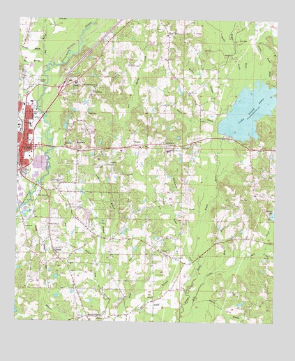
Laurel East, MS USGS Topographic Map
Click on map above to begin viewing in our Map Viewer.

This topographic map contains these locations and features:
Feature Name Type Latitude Longitude GNIS ID View Map
AntiochPopulated PlaceN31.6338°W89.0581°666285View Map
Antioch CemeteryCemeteryN31.6535°W89.0512°707408View Map
Antioch ChurchChurchN31.6538°W89.0514°666302View Map
Bee BranchStreamN31.7324°W89.1112°666747View Map
Bethlehem Baptist ChurchChurchN31.6985°W89.0398°685452View Map
Bethlehem School (historical)SchoolN31.6982°W89.0398°685453View Map
Bible Baptist ChurchChurchN31.6768°W89.1156°667067View Map
Big Reedy CreekStreamN31.7310°W89.1103°691538View Map
Blacksnake CreekStreamN31.6679°W89.0356°667253View Map
Bogue CheelyStreamN31.7077°W89.0295°667377View Map
Brushy BranchStreamN31.7352°W89.1128°667681View Map
Buck BranchStreamN31.6457°W89.0295°667721View Map
Channel BranchStreamN31.6596°W89.0820°668310View Map
Church of GodChurchN31.7010°W89.1214°685467View Map
Clark CemeteryCemeteryN31.6757°W89.0170°668507View Map
CleoPopulated PlaceN31.7004°W89.0367°668597View Map
Double BranchStreamN31.6302°W89.0392°693104View Map
Dry BranchStreamN31.6488°W89.0862°669399View Map
Dry Swamp CreekStreamN31.6371°W89.0426°669460View Map
East Jerusalem Baptist ChurchChurchN31.6929°W89.1231°685479View Map
East Pleasant Grove ChurchChurchN31.7224°W89.0870°669599View Map
EastviewPopulated PlaceN31.6971°W89.0912°669633View Map
Emmanuel Baptist ChurchChurchN31.6518°W89.0484°669767View Map
Fall CemeteryCemeteryN31.7377°W89.0350°669900View Map
GladePopulated PlaceN31.6552°W89.1073°670415View Map
Glade Baptist ChurchChurchN31.6535°W89.1051°685500View Map
Glade ChurchChurchN31.6491°W89.0995°670418View Map
Glade Elementary SchoolSchoolN31.6541°W89.1059°707352View Map
Glade Volunteer Fire DepartmentBuildingN31.6271°W89.0800°2667701View Map
GlastonPopulated PlaceN31.6591°W89.0784°686107View Map
Goodwill ChurchChurchN31.6641°W89.1206°670509View Map
Hood Lumber Company DamDamN31.7285°W89.1217°680857View Map
Huddleston School (historical)SchoolN31.6843°W89.0042°685512View Map
Interchange 96BCrossingN31.6874°W89.1228°691493View Map
Interchange 97CrossingN31.6979°W89.1173°691494View Map
Interchange 99CrossingN31.7215°W89.1039°691495View Map
Lake Bogue HomoReservoirN31.7125°W89.0134°667394View Map
Lake Bogue Homo DamDamN31.7018°W89.0201°680839View Map
Lake ChurchChurchN31.6966°W89.0087°672254View Map
Laurel Fire Department Station 2BuildingN31.7035°W89.1217°2667780View Map
Lawn Haven Baptist ChurchChurchN31.6993°W89.0542°672327View Map
Little Bogue HomoStreamN31.7243°W89.0056°672553View Map
Little Mill CreekStreamN31.6538°W89.0053°672640View Map
Longino School (historical)SchoolN31.6327°W89.0070°685528View Map
Masonite Lake DamDamN31.6685°W89.0001°680816View Map
Masonite Lake DamDamN31.6702°W89.1167°680817View Map
Memorial Park CemeteryCemeteryN31.6968°W89.0506°673471View Map
Morning Star Baptist ChurchChurchN31.6871°W89.1206°685535View Map
Mount OlivePopulated PlaceN31.7443°W89.0523°692089View Map
Mount Olive Baptist ChurchChurchN31.7440°W89.0514°685541View Map
Mount Olive CemeteryCemeteryN31.7435°W89.0542°707371View Map
Mount Olive SchoolSchoolN31.7435°W89.0534°707372View Map
Mount Oral Baptist ChurchChurchN31.6960°W89.0959°685542View Map
Mount Oral CemeteryCemeteryN31.6963°W89.0959°707373View Map
Mount Vernon CemeteryCemeteryN31.6649°W89.1098°707374View Map
Mount Vernon ChurchChurchN31.6652°W89.1095°674294View Map
Mount Vernon School (historical)SchoolN31.6527°W89.1064°685545View Map
Nora Davis Elementary SchoolSchoolN31.7063°W89.1192°711625View Map
Nora Davis Memorial CemeteryCemeteryN31.7207°W89.0895°674931View Map
Northeast Jones High SchoolSchoolN31.6957°W89.0520°707379View Map
Odoms Lake DamDamN31.7085°W89.1017°680841View Map
Old Meeting House HillSummitN31.6646°W89.1092°685557View Map
Old Place BranchStreamN31.6296°W89.0639°675224View Map
Pine View ChurchChurchN31.7199°W89.0428°675883View Map
Pleasant Grove School (historical)SchoolN31.7218°W89.0867°685570View Map
Pleasant Valley Missionary Baptist ChurchChurchN31.7010°W89.1195°685571View Map
PowersPopulated PlaceN31.6979°W89.0687°676294View Map
Powers Elementary SchoolSchoolN31.6971°W89.0659°707387View Map
Powers Volunteer Fire DepartmentBuildingN31.6981°W89.0576°2668071View Map
Providence Baptist ChurchChurchN31.7127°W89.1203°685574View Map
Providence CemeteryCemeteryN31.6424°W89.0045°710708View Map
Rashee BranchStreamN31.6946°W89.0284°676477View Map
Reedy CreekStreamN31.7193°W89.0187°676576View Map
Smiley Sewage Lagoon DamDamN31.6885°W89.1151°680829View Map
Smith ChapelChurchN31.7310°W89.0703°677913View Map
Supervisor District 3CivilN31.6266°W89.0226°711921View Map
Tuckers CrossingPopulated PlaceN31.6274°W89.0901°691625View Map
Tuckers Crossing Baptist ChurchChurchN31.6271°W89.0923°685609View Map
WNSL-FM (Laurel)TowerN31.6832°W89.1009°680201View Map
WQIS-AM (Laurel)TowerN31.6832°W89.1009°680089View Map

Note: Coordinates in the location and feature list above are referenced to NAD83 datum.


Copyright (C) 2008-2025 Ryan Niemi / Sunset Dynamics ... All Rights Reserved