TopoQuest Logo
Do you find TopoQuest useful?
Help keep TopoQuest running and adding new maps/features by donating!
Bitcoin:  19c7KJd3qBynnjoSw5npx9KScwjBe4ifkT
Litecoin:  LXs6TkuXGGXo1vDsWCkWVdjQX94eUKd6ui
Home View Maps Find Maps Find Places Resources & Links


Glendale Springs, North Carolina Topographic Map

USGS Map Title: Glendale Springs, NC
USGS Map MRC: 36081C4
DRG (GeoTIFF) Download: o36081c4.tif


Neighboring USGS Topographic Map Quads:


  Warrensville, NC  
36081D5
 

  Jefferson, NC  
36081D4
 

  Laurel Springs, NC  
36081D3
 

  Todd, NC  
36081C5
 

  Glendale Springs, NC  
36081C4
 

  Horse Gap, NC  
36081C3
 

  Deep Gap, NC  
36081B5
 

  Maple Springs, NC  
36081B4
 

  Purlear, NC  
36081B3


Map MRC Location:

N37°
W82°
N37°
W81°
H8 H7 H6 H5 H4 H3 H2 H1
G8 G7 G6 G5 G4 G3 G2 G1
F8 F7 F6 F5 F4 F3 F2 F1
E8 E7 E6 E5 E4 E3 E2 E1
D8 D7 D6 D5 D4 D3 D2 D1
C8 C7 C6 C5 C4 C3 C2 C1
B8 B7 B6 B5 B4 B3 B2 B1
A8 A7 A6 A5 A4 A3 A2 A1
N36°
W82°
N36°
W81°

Glendale Springs, NC USGS 1:24K Topographic Map Preview:
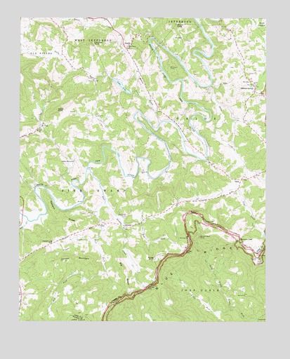
Glendale Springs, NC USGS Topographic Map
Click on map above to begin viewing in our Map Viewer.

This topographic map contains these locations and features:
Feature Name Type Latitude Longitude GNIS ID View Map
Ashe Lake DamDamN36.3435°W81.4432°1000532View Map
Beaver CreekStreamN36.3318°W81.4287°980796View Map
Benge GapGapN36.2790°W81.4154°980988View Map
Benge KnobSummitN36.2754°W81.4315°980989View Map
Bethel ChurchChurchN36.3346°W81.4609°981173View Map
Betseys Rock FallsFallsN36.2850°W81.4085°981244View Map
Big Ivy ChurchChurchN36.2607°W81.3851°981412View Map
Big RidgeRidgeN36.2701°W81.4459°981445View Map
Blue Ridge ChurchChurchN36.2843°W81.4143°981632View Map
Blue Ridge ChurchChurchN36.3490°W81.3826°981633View Map
Calloway GapGapN36.2849°W81.3882°982435View Map
Calvary ChurchChurchN36.3529°W81.3807°982462View Map
Cole BranchStreamN36.3740°W81.4762°983361View Map
East Fork Pine Swamp CreekStreamN36.2899°W81.4468°984505View Map
Elk Shoals CampLocaleN36.3548°W81.4243°984706View Map
Frenches KnobSummitN36.3648°W81.4632°985407View Map
Gap CreekStreamN36.2915°W81.4957°1020394View Map
Glendale SpringsPopulated PlaceN36.3451°W81.3804°1020447View Map
Glendale Springs Post OfficePost OfficeN36.3444°W81.3807°2774340View Map
Glendale Springs Volunteer Fire DepartmentBuildingN36.3457°W81.3806°2639183View Map
Henson MountainSummitN36.2754°W81.4662°1020689View Map
Hewed Log GapGapN36.2824°W81.4829°986675View Map
Holy Trinity ChurchChurchN36.3468°W81.3804°987000View Map
IdlewildPopulated PlaceN36.2893°W81.4462°987318View Map
Lake AsheLakeN36.3470°W81.4482°980320View Map
Little ForkStreamN36.2557°W81.3909°988647View Map
Mount Jefferson OverlookLocaleN36.2949°W81.4132°990422View Map
Mount Olive ChurchChurchN36.3290°W81.4901°990488View Map
Nathens RidgeRidgeN36.2937°W81.4809°990873View Map
Nettle KnobSummitN36.3371°W81.4809°990916View Map
North Beaver ChurchChurchN36.3629°W81.4454°991194View Map
ObidsPopulated PlaceN36.3085°W81.3870°1006316View Map
Obids CreekStreamN36.3468°W81.4048°991505View Map
Old Field ChurchChurchN36.2940°W81.4620°991550View Map
OthelloPopulated PlaceN36.3623°W81.4462°1021763View Map
OvalPopulated PlaceN36.3304°W81.4882°1006322View Map
Oval ChurchChurchN36.3365°W81.4720°991736View Map
Phillips GapGapN36.2643°W81.4351°992147View Map
Pine Swamp ChurchChurchN36.2932°W81.4473°992287View Map
Pine Swamp CreekStreamN36.3129°W81.4654°992289View Map
Riverview ChurchChurchN36.3118°W81.4384°993400View Map
Round KnobSummitN36.3726°W81.4207°993745View Map
Round Knob ChurchChurchN36.3665°W81.4176°993746View Map
South Beaver CreekStreamN36.3371°W81.4309°995125View Map
Stephens Memorial ChurchChurchN36.3160°W81.4720°995467View Map
The LumpSummitN36.2743°W81.3793°1022923View Map
The Lump OverlookLocaleN36.2760°W81.3790°995988View Map
Township of ObidsCivilN36.3312°W81.3973°1026390View Map
Township of Pine SwampCivilN36.2971°W81.4783°1026393View Map
Walsh (historical)Populated PlaceN36.2637°W81.3862°1960032View Map
West Fork Pine Swamp CreekStreamN36.3129°W81.4654°997018View Map
Wolfpen CreekStreamN36.2835°W81.4618°997552View Map
YatesPopulated PlaceN36.2899°W81.4590°997691View Map

Note: Coordinates in the location and feature list above are referenced to NAD83 datum.


Copyright (C) 2008-2024 Ryan Niemi / Sunset Dynamics ... All Rights Reserved