TopoQuest Logo
Do you find TopoQuest useful?
Help keep TopoQuest running and adding new maps/features by donating!
Bitcoin:  19c7KJd3qBynnjoSw5npx9KScwjBe4ifkT
Litecoin:  LXs6TkuXGGXo1vDsWCkWVdjQX94eUKd6ui
Home View Maps Find Maps Find Places Resources & Links


Horse Gap, North Carolina Topographic Map

USGS Map Title: Horse Gap, NC
USGS Map MRC: 36081C3
DRG (GeoTIFF) Download: o36081c3.tif


Neighboring USGS Topographic Map Quads:


  Jefferson, NC  
36081D4
 

  Laurel Springs, NC  
36081D3
 

  Whitehead, NC  
36081D2
 

  Glendale Springs, NC  
36081C4
 

  Horse Gap, NC  
36081C3
 

  McGrady, NC  
36081C2
 

  Maple Springs, NC  
36081B4
 

  Purlear, NC  
36081B3
 

  Wilkesboro, NC  
36081B2


Map MRC Location:

N37°
W82°
N37°
W81°
H8 H7 H6 H5 H4 H3 H2 H1
G8 G7 G6 G5 G4 G3 G2 G1
F8 F7 F6 F5 F4 F3 F2 F1
E8 E7 E6 E5 E4 E3 E2 E1
D8 D7 D6 D5 D4 D3 D2 D1
C8 C7 C6 C5 C4 C3 C2 C1
B8 B7 B6 B5 B4 B3 B2 B1
A8 A7 A6 A5 A4 A3 A2 A1
N36°
W82°
N36°
W81°

Horse Gap, NC USGS 1:24K Topographic Map Preview:
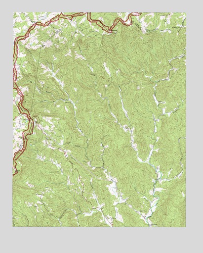
Horse Gap, NC USGS Topographic Map
Click on map above to begin viewing in our Map Viewer.

This topographic map contains these locations and features:
Feature Name Type Latitude Longitude GNIS ID View Map
Alder GapGapN36.3696°W81.2898°980081View Map
Antioch ChurchChurchN36.3501°W81.2529°980249View Map
Aren Beshears DamDamN36.2585°W81.3598°1000432View Map
Bear Den BranchStreamN36.3240°W81.3423°980719View Map
Bethel ChurchChurchN36.3229°W81.2693°981172View Map
Bowlin CreekStreamN36.3246°W81.3343°981773View Map
Buckwheat BranchStreamN36.3157°W81.2662°982153View Map
Bumgarner BranchStreamN36.2604°W81.3109°982245View Map
Clear BranchStreamN36.2957°W81.3223°983251View Map
Cross MountainSummitN36.3562°W81.3554°1019867View Map
Daniels GapGapN36.3015°W81.3668°983944View Map
Darnell CreekStreamN36.2879°W81.2768°983963View Map
DayloLocaleN36.2846°W81.3087°1023482View Map
Dogwood BranchStreamN36.2862°W81.3190°984258View Map
Garner MountainSummitN36.3610°W81.3120°985575View Map
Gillam GapGapN36.2832°W81.3732°985693View Map
Horse GapGapN36.3135°W81.3632°987097View Map
Judd MountainSummitN36.2512°W81.3487°1020995View Map
Jumpinoff Rock OverlookLocaleN36.3182°W81.3673°987824View Map
K O A DamDamN36.2751°W81.3482°1000454View Map
Laurel RidgeRidgeN36.3729°W81.2648°988207View Map
Lester (historical)Populated PlaceN36.3237°W81.2518°1960001View Map
Meditation MountainSummitN36.3068°W81.3598°1021406View Map
Mill CreekStreamN36.2787°W81.2681°989956View Map
Miller ChurchChurchN36.3071°W81.2904°989999View Map
Miller GapGapN36.3443°W81.3745°990004View Map
Millers Store (historical)LocaleN36.3057°W81.2890°1960005View Map
Moravian Camp LakeReservoirN36.3695°W81.2632°1000557View Map
Moravian Camp Lake DamDamN36.3701°W81.2631°1000556View Map
Mulberry GapGapN36.3665°W81.2537°990778View Map
New Light ChurchChurchN36.2840°W81.2712°991069View Map
NonameReservoirN36.2585°W81.3598°1000431View Map
NonameReservoirN36.2751°W81.3482°1000453View Map
Oak Grove ChurchChurchN36.2690°W81.3540°991400View Map
Old 16 ChurchChurchN36.3079°W81.3287°991528View Map
Old Taylor BranchStreamN36.2582°W81.3254°991614View Map
Osborn CreekStreamN36.3346°W81.2712°991701View Map
Piney RidgeRidgeN36.2885°W81.3351°992393View Map
Piney Ridge ChurchChurchN36.3015°W81.3498°992395View Map
Poplar Cove ChurchChurchN36.3226°W81.3323°992684View Map
Reddies River ChurchChurchN36.2593°W81.2831°993142View Map
Robbins BranchStreamN36.2843°W81.3101°993442View Map
Roberts Store (historical)LocaleN36.3237°W81.3351°1960020View Map
Roten CreekStreamN36.3210°W81.3309°993726View Map
Royals Mill (historical)LocaleN36.3362°W81.2623°1960021View Map
Sheets GapGapN36.3651°W81.3051°994628View Map
Sheets Gap OverlookLocaleN36.3640°W81.3045°994629View Map
Shepherds Store (historical)LocaleN36.3160°W81.2665°1960022View Map
ShermanLocaleN36.3404°W81.3462°1023487View Map
ShoeLocaleN36.2615°W81.3582°994757View Map
Snider BranchStreamN36.2615°W81.2745°995056View Map
Stanley BranchStreamN36.3410°W81.3465°995410View Map
Township of UnionCivilN36.2976°W81.3029°1027339View Map
Union ChurchChurchN36.2554°W81.3037°996464View Map
Union Township SchoolSchoolN36.2515°W81.2754°996517View Map
VannoyPopulated PlaceN36.3135°W81.2731°1023073View Map
WilbarLocaleN36.2615°W81.3115°1023488View Map
Wilbar Volunteer Fire Department Main StationBuildingN36.2542°W81.3067°2639268View Map
Wilbar Volunteer Fire Department SubstationBuildingN36.3703°W81.3331°2639351View Map
Wingler CreekStreamN36.3057°W81.2890°997491View Map

Note: Coordinates in the location and feature list above are referenced to NAD83 datum.


Copyright (C) 2008-2024 Ryan Niemi / Sunset Dynamics ... All Rights Reserved