TopoQuest Logo
Do you find TopoQuest useful?
Help keep TopoQuest running and adding new maps/features by donating!
Bitcoin:  19c7KJd3qBynnjoSw5npx9KScwjBe4ifkT
Litecoin:  LXs6TkuXGGXo1vDsWCkWVdjQX94eUKd6ui
Home View Maps Find Maps Find Places Resources & Links


Bartlett, Missouri Topographic Map

USGS Map Title: Bartlett, MO
USGS Map MRC: 37091A4
DRG (GeoTIFF) Download: o37091a4.tif


Neighboring USGS Topographic Map Quads:


  Summersville NE, MO  
37091B5
 

  Alley Spring, MO  
37091B4
 

  Eminence, MO  
37091B3
 

  Jam Up Cave, MO  
37091A5
 

  Bartlett, MO  
37091A4
 

  Winona, MO  
37091A3
 

  Montier, MO  
36091H5
 

  Birch Tree, MO  
36091H4
 

  Low Wassie, MO  
36091H3


Map MRC Location:

N38°
W92°
N38°
W91°
H8 H7 H6 H5 H4 H3 H2 H1
G8 G7 G6 G5 G4 G3 G2 G1
F8 F7 F6 F5 F4 F3 F2 F1
E8 E7 E6 E5 E4 E3 E2 E1
D8 D7 D6 D5 D4 D3 D2 D1
C8 C7 C6 C5 C4 C3 C2 C1
B8 B7 B6 B5 B4 B3 B2 B1
A8 A7 A6 A5 A4 A3 A2 A1
N37°
W92°
N37°
W91°

Bartlett, MO USGS 1:24K Topographic Map Preview:
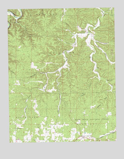
Bartlett, MO USGS Topographic Map
Click on map above to begin viewing in our Map Viewer.

This topographic map contains these locations and features:
Feature Name Type Latitude Longitude GNIS ID View Map
BartlettPopulated PlaceN37.0048°W91.4143°748694View Map
Big BranchStreamN37.1195°W91.3879°748823View Map
Buckhart SpringSpringN37.0570°W91.3851°749089View Map
Buckhart Springs (historical)Populated PlaceN37.0559°W91.3849°740127View Map
Crescent SchoolSchoolN37.0653°W91.4015°747797View Map
DelawarePopulated PlaceN37.1034°W91.4082°749616View Map
Delaware CemeteryCemeteryN37.1034°W91.4093°749617View Map
Dry Camp HollowValleyN37.0681°W91.4399°749706View Map
GatewayLocaleN37.0020°W91.3976°754391View Map
Gateway Camp and Picnic AreaLocaleN37.0009°W91.3985°754049View Map
Island BranchStreamN37.1164°W91.4876°748570View Map
Jam Up HollowValleyN37.0828°W91.4359°750494View Map
Larkin HollowValleyN37.0914°W91.4231°750657View Map
Manger of Bethlehem ChurchChurchN37.0134°W91.4921°750916View Map
Open HollowValleyN37.0970°W91.4023°751442View Map
PertzLocaleN37.0726°W91.4349°740289View Map
Pin Oak HollowValleyN37.0937°W91.3977°751596View Map
Pine HollowValleyN37.1028°W91.4069°751612View Map
Pine Hollow School (historical)SchoolN37.0748°W91.4337°747796View Map
Rader CemeteryCemeteryN37.1000°W91.4062°751790View Map
Railroad HollowValleyN37.0474°W91.3808°751801View Map
Spring Camp HollowValleyN37.0644°W91.4561°752297View Map
Township of DelawareCivilN37.0819°W91.4323°767397View Map
Turnback HollowValleyN37.0598°W91.3946°752617View Map
Woodland SchoolSchoolN37.0020°W91.4471°747795View Map

Note: Coordinates in the location and feature list above are referenced to NAD83 datum.


Copyright (C) 2008-2025 Ryan Niemi / Sunset Dynamics ... All Rights Reserved