TopoQuest Logo
Do you find TopoQuest useful?
Help keep TopoQuest running and adding new maps/features by donating!
Bitcoin:  19c7KJd3qBynnjoSw5npx9KScwjBe4ifkT
Litecoin:  LXs6TkuXGGXo1vDsWCkWVdjQX94eUKd6ui
Home View Maps Find Maps Find Places Resources & Links


Jam Up Cave, Missouri Topographic Map

USGS Map Title: Jam Up Cave, MO
USGS Map MRC: 37091A5
DRG (GeoTIFF) Download: o37091a5.tif


Neighboring USGS Topographic Map Quads:


  Summersville, MO  
37091B6
 

  Summersville NE, MO  
37091B5
 

  Alley Spring, MO  
37091B4
 

  Pine Crest, MO  
37091A6
 

  Jam Up Cave, MO  
37091A5
 

  Bartlett, MO  
37091A4
 

  Mountain View, MO  
36091H6
 

  Montier, MO  
36091H5
 

  Birch Tree, MO  
36091H4


Map MRC Location:

N38°
W92°
N38°
W91°
H8 H7 H6 H5 H4 H3 H2 H1
G8 G7 G6 G5 G4 G3 G2 G1
F8 F7 F6 F5 F4 F3 F2 F1
E8 E7 E6 E5 E4 E3 E2 E1
D8 D7 D6 D5 D4 D3 D2 D1
C8 C7 C6 C5 C4 C3 C2 C1
B8 B7 B6 B5 B4 B3 B2 B1
A8 A7 A6 A5 A4 A3 A2 A1
N37°
W92°
N37°
W91°

Jam Up Cave, MO USGS 1:24K Topographic Map Preview:
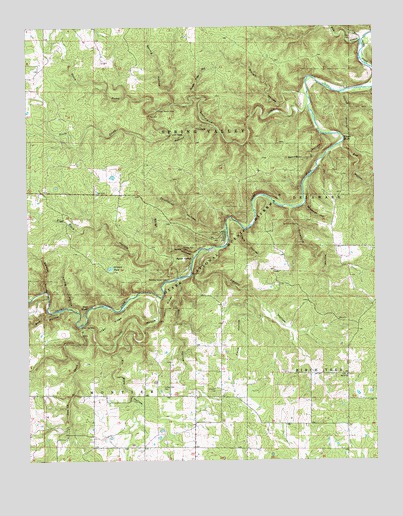
Jam Up Cave, MO USGS Topographic Map
Click on map above to begin viewing in our Map Viewer.

This topographic map contains these locations and features:
Feature Name Type Latitude Longitude GNIS ID View Map
Angel RidgeRidgeN37.0385°W91.5989°713297View Map
Bay CreekStreamN37.1209°W91.5043°713753View Map
Bay Creek CampsiteParkN37.1231°W91.5018°741841View Map
Bay Creek River AccessLocaleN37.1231°W91.5018°741840View Map
Bear HollowValleyN37.0432°W91.6139°713820View Map
Bee BluffCliffN37.1109°W91.5218°736242View Map
Bee HollowValleyN37.1056°W91.5111°748765View Map
Bee Hollow BranchStreamN37.1058°W91.5122°2710695View Map
Berea ChurchChurchN37.0245°W91.5107°713979View Map
Bill HollowValleyN37.0520°W91.5710°714234View Map
Bunker Hill RanchLocaleN37.0648°W91.5546°736241View Map
Chalk BluffCliffN37.0926°W91.5107°715702View Map
Dark HollowValleyN37.0667°W91.5472°716669View Map
Daveys HollowValleyN37.0491°W91.6198°716689View Map
Dry HollowValleyN37.1009°W91.5779°739890View Map
Duncan CemeteryCemeteryN37.0209°W91.5582°717176View Map
Dyer CemeteryCemeteryN37.1217°W91.5082°717224View Map
Flat Rock HollowValleyN37.0530°W91.5707°717996View Map
Floyd HollowValleyN37.0488°W91.5461°718041View Map
Fly Blow HollowValleyN37.0386°W91.5842°718044View Map
Gilmore PondLakeN37.0556°W91.5954°718462View Map
Hughes HollowValleyN37.0470°W91.6241°719974View Map
Jam Up CreekStreamN37.0389°W91.6063°720240View Map
Jenny RidgeRidgeN37.0364°W91.5785°720306View Map
Johnny HollowValleyN37.0606°W91.5569°720343View Map
Leatherwood CreekStreamN37.1020°W91.5235°720868View Map
Liberty School (historical)SchoolN37.0037°W91.5476°747787View Map
Lost HollowValleyN37.0464°W91.5781°721597View Map
Low GapGapN37.0937°W91.5732°721631View Map
Muck Forty HoleChannelN37.0467°W91.6243°737936View Map
North Prong Leatherwood CreekStreamN37.1012°W91.5782°723491View Map
Red BluffCliffN37.0445°W91.6035°725150View Map
Rough HollowValleyN37.0598°W91.5654°725593View Map
Rough HollowValleyN37.1056°W91.5263°725594View Map
Rymer RanchLocaleN37.0567°W91.5635°747785View Map
Rymer SpringSpringN37.0581°W91.5661°725699View Map
Rymers River AccessLocaleN37.0609°W91.5601°741722View Map
Science Ridge School (historical)SchoolN37.0253°W91.5249°747786View Map
South Prong Leatherwood CreekStreamN37.1012°W91.5782°726781View Map
Spring HollowValleyN37.0431°W91.6071°726934View Map
Spring HollowValleyN37.0939°W91.5193°726936View Map
Spring HollowValleyN37.1034°W91.5721°726940View Map
Stillhouse HollowValleyN37.0670°W91.5546°727108View Map
Stillhouse HollowValleyN37.0906°W91.5125°727109View Map
Stony Point School (historical)SchoolN37.0617°W91.5085°747784View Map
Sugar Tree HollowValleyN37.1051°W91.5640°727251View Map
Sycamore HollowValleyN37.0726°W91.5304°727414View Map
Tin Roof (historical)Populated PlaceN37.0834°W91.5417°2664276View Map
Township of MontierCivilN37.0090°W91.5974°767400View Map
Turkey Oak CemeteryCemeteryN37.0203°W91.5771°727878View Map
Turkey Oak SchoolSchoolN37.0192°W91.5768°747783View Map
Walnut HollowValleyN37.0962°W91.5571°728322View Map

Note: Coordinates in the location and feature list above are referenced to NAD83 datum.


Copyright (C) 2008-2024 Ryan Niemi / Sunset Dynamics ... All Rights Reserved