TopoQuest Logo
Do you find TopoQuest useful?
Help keep TopoQuest running and adding new maps/features by donating!
Bitcoin:  19c7KJd3qBynnjoSw5npx9KScwjBe4ifkT
Litecoin:  LXs6TkuXGGXo1vDsWCkWVdjQX94eUKd6ui
Home View Maps Find Maps Find Places Resources & Links


Winona, Missouri Topographic Map

USGS Map Title: Winona, MO
USGS Map MRC: 37091A3
DRG (GeoTIFF) Download: o37091a3.tif


Neighboring USGS Topographic Map Quads:


  Alley Spring, MO  
37091B4
 

  Eminence, MO  
37091B3
 

  Powder Mill Ferry, MO  
37091B2
 

  Bartlett, MO  
37091A4
 

  Winona, MO  
37091A3
 

  Stegall Mountain, MO  
37091A2
 

  Birch Tree, MO  
36091H4
 

  Low Wassie, MO  
36091H3
 

  Fremont, MO  
36091H2


Map MRC Location:

N38°
W92°
N38°
W91°
H8 H7 H6 H5 H4 H3 H2 H1
G8 G7 G6 G5 G4 G3 G2 G1
F8 F7 F6 F5 F4 F3 F2 F1
E8 E7 E6 E5 E4 E3 E2 E1
D8 D7 D6 D5 D4 D3 D2 D1
C8 C7 C6 C5 C4 C3 C2 C1
B8 B7 B6 B5 B4 B3 B2 B1
A8 A7 A6 A5 A4 A3 A2 A1
N37°
W92°
N37°
W91°

Winona, MO USGS 1:24K Topographic Map Preview:
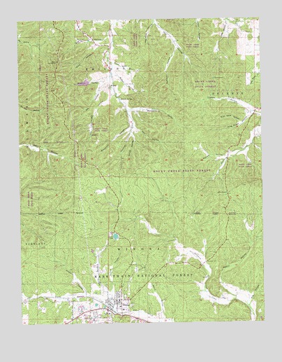
Winona, MO USGS Topographic Map
Click on map above to begin viewing in our Map Viewer.

This topographic map contains these locations and features:
Feature Name Type Latitude Longitude GNIS ID View Map
Abe HollowValleyN37.0987°W91.3324°748554View Map
Allen PondLakeN37.0534°W91.2685°748576View Map
Appletree HollowValleyN37.1237°W91.3046°748605View Map
Big HollowValleyN37.0087°W91.2562°748839View Map
Big Spring SchoolSchoolN37.0189°W91.2790°747800View Map
Black ValleyValleyN37.1078°W91.3279°748893View Map
Blackroot HollowValleyN37.0801°W91.3179°748897View Map
Church PondLakeN37.1004°W91.2746°749359View Map
City of WinonaCivilN37.0042°W91.3270°2397349View Map
Deel Lake DamDamN37.1000°W91.3385°764900View Map
District Office Forest Service - USDABuildingN37.0103°W91.3271°753415View Map
East HollowValleyN37.0809°W91.3154°749780View Map
Emory HollowValleyN37.1181°W91.3287°749841View Map
Hickory HollowValleyN37.0131°W91.3424°750308View Map
Hunt Lake DamDamN37.0084°W91.3368°764911View Map
Kemper HollowValleyN37.0681°W91.2679°750586View Map
Klepzig HollowValleyN37.0131°W91.3312°750633View Map
Lewis LakeReservoirN37.0358°W91.3261°750692View Map
Lewis Lake Picnic AreaLocaleN37.0351°W91.3251°754962View Map
Lions Club ParkParkN37.0142°W91.3312°754058View Map
Mahan Roadside ParkParkN37.1078°W91.3546°750907View Map
Marie HollowValleyN37.0020°W91.3012°750930View Map
Mark Twain National Forest Eleven Point Ranger District Winona OfficeBuildingN37.0157°W91.3232°2620728View Map
Martin HollowValleyN37.0106°W91.2649°750948View Map
Millman HollowValleyN37.0992°W91.3324°751101View Map
Mononame 148 DamDamN37.0351°W91.3268°764055View Map
MunsellPopulated PlaceN37.0981°W91.3276°751236View Map
Munsell School (historical)SchoolN37.1025°W91.3287°747798View Map
Munsell SpringSpringN37.0923°W91.3224°751237View Map
Nash HollowValleyN37.1153°W91.3276°751260View Map
Overstreet HollowValleyN37.0948°W91.3268°751460View Map
Pine Lawn CemeteryCemeteryN37.0078°W91.3182°751618View Map
Pine Ridge HollowValleyN37.0856°W91.2549°751624View Map
Pleasant ValleyValleyN37.0881°W91.3179°751672View Map
Rocky Creek State ForestForestN37.0900°W91.2887°753705View Map
ShawnePopulated PlaceN37.1214°W91.2604°739896View Map
Sink Hole HollowValleyN37.0825°W91.2612°752175View Map
South HollowValleyN37.0778°W91.3165°752265View Map
Summer HollowValleyN37.1134°W91.2935°752429View Map
Sutton HollowValleyN37.0137°W91.3282°752447View Map
Sutton HollowValleyN37.1020°W91.3251°752448View Map
Sutton MineMineN37.0984°W91.3160°752449View Map
Thomas HollowValleyN37.0864°W91.2551°752528View Map
Township of WinonaCivilN37.0084°W91.2774°767405View Map
Williams CemeteryCemeteryN37.0250°W91.2790°752911View Map
WinonaPopulated PlaceN37.0098°W91.3235°752941View Map
Winona Junction (historical)LocaleN37.0106°W91.3693°747799View Map
Winona Police DepartmentBuildingN37.0092°W91.3247°2752290View Map
Winona Post OfficePost OfficeN37.0079°W91.3258°2782909View Map
Winona Volunteer Fire DepartmentBuildingN37.0092°W91.3248°2620322View Map

Note: Coordinates in the location and feature list above are referenced to NAD83 datum.


Copyright (C) 2008-2024 Ryan Niemi / Sunset Dynamics ... All Rights Reserved