TopoQuest Logo
Do you find TopoQuest useful?
Help keep TopoQuest running and adding new maps/features by donating!
Bitcoin:  19c7KJd3qBynnjoSw5npx9KScwjBe4ifkT
Litecoin:  LXs6TkuXGGXo1vDsWCkWVdjQX94eUKd6ui
Home View Maps Find Maps Find Places Resources & Links


Marianna, Mississippi Topographic Map

USGS Map Title: Marianna, MS
USGS Map MRC: 34089F5
DRG (GeoTIFF) Download: o34089f5.tif


Neighboring USGS Topographic Map Quads:


  Byhalia, MS  
34089G6
 

  Red Banks, MS  
34089G5
 

  Holly Springs, MS  
34089G4
 

  Wyatte, MS  
34089F6
 

  Marianna, MS  
34089F5
 

  Waterford, MS  
34089F4
 

  Tyro, MS  
34089E6
 

  Laws Hill, MS  
34089E5
 

  Malone, MS  
34089E4


Map MRC Location:

N35°
W90°
N35°
W89°
H8 H7 H6 H5 H4 H3 H2 H1
G8 G7 G6 G5 G4 G3 G2 G1
F8 F7 F6 F5 F4 F3 F2 F1
E8 E7 E6 E5 E4 E3 E2 E1
D8 D7 D6 D5 D4 D3 D2 D1
C8 C7 C6 C5 C4 C3 C2 C1
B8 B7 B6 B5 B4 B3 B2 B1
A8 A7 A6 A5 A4 A3 A2 A1
N34°
W90°
N34°
W89°

Marianna, MS USGS 1:24K Topographic Map Preview:
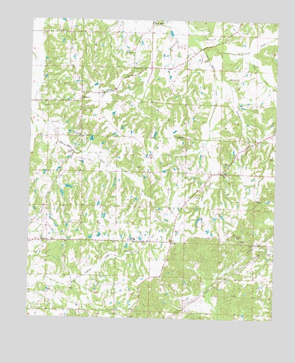
Marianna, MS USGS Topographic Map
Click on map above to begin viewing in our Map Viewer.

This topographic map contains these locations and features:
Feature Name Type Latitude Longitude GNIS ID View Map
Brewer CemeteryCemeteryN34.6529°W89.5762°667545View Map
Brooks CemeteryCemeteryN34.6529°W89.5034°667598View Map
Chew CreekStreamN34.7365°W89.5154°692887View Map
Chulahoma CemeteryCemeteryN34.6565°W89.6145°683792View Map
Chulahoma ChurchChurchN34.6568°W89.6154°668440View Map
Cox CemeteryCemeteryN34.6573°W89.6134°668915View Map
Dean CemeteryCemeteryN34.6370°W89.6037°669176View Map
Dean CemeteryCemeteryN34.6370°W89.6137°669177View Map
GalenaPopulated PlaceN34.6570°W89.5523°691876View Map
Galena SchoolSchoolN34.6582°W89.5709°670286View Map
J K Hurdle Lake DamDamN34.6851°W89.5067°682775View Map
Jones CemeteryCemeteryN34.7015°W89.5979°671975View Map
Jones CreekStreamN34.7012°W89.5340°671993View Map
Jones School (historical)SchoolN34.7007°W89.5990°683818View Map
MariannaPopulated PlaceN34.7176°W89.5990°693872View Map
Marvel CemeteryCemeteryN34.7298°W89.5729°673202View Map
Marvin ChurchChurchN34.7193°W89.5990°673206View Map
McCarley School (historical)SchoolN34.6637°W89.6237°706315View Map
McIntyre ChurchChurchN34.6898°W89.5237°673375View Map
McIntyre School (historical)SchoolN34.6895°W89.5240°683829View Map
Mount Gillie CemeteryCemeteryN34.6565°W89.5648°1959771View Map
Mount Gillie ChurchChurchN34.6568°W89.5656°674012View Map
Mount Marie School (historical)SchoolN34.7365°W89.5734°683832View Map
Mount Moriah ChurchChurchN34.7368°W89.5740°674084View Map
Mount Peel Missionary Baptist ChurchChurchN34.6270°W89.5801°674182View Map
Nunnally CemeteryCemeteryN34.7259°W89.5240°674991View Map
Nunnally CreekStreamN34.7376°W89.5379°694220View Map
Shiloh Hill School (historical)SchoolN34.6412°W89.5545°683857View Map
Smith Grove CemeteryCemeteryN34.6934°W89.5623°683860View Map
Smith Grove ChurchChurchN34.6932°W89.5634°677935View Map
Street Hill ChurchChurchN34.7015°W89.5990°678351View Map
Supervisor District 4CivilN34.7055°W89.6139°711985View Map
Union Valley ChurchChurchN34.7451°W89.6120°679121View Map
Union Valley School (historical)SchoolN34.7451°W89.6123°683868View Map
Wilkins CemeteryCemeteryN34.6601°W89.5198°679690View Map
Wilkins Chapel (historical)ChurchN34.6265°W89.5084°683873View Map
Wilkins ChurchChurchN34.6573°W89.5151°679693View Map
Wilkins CreekStreamN34.7268°W89.5315°679694View Map
Wilkins School (historical)SchoolN34.6637°W89.5176°683874View Map
Yarbrough CemeteryCemeteryN34.7015°W89.5465°679917View Map
Yarbrough Chapel Christian Methodist Episcopal ChurchChurchN34.6865°W89.5270°679918View Map
Yarbrough Church (historical)ChurchN34.7009°W89.5459°683876View Map
Yarbrough School (historical)SchoolN34.7007°W89.5456°683877View Map

Note: Coordinates in the location and feature list above are referenced to NAD83 datum.


Copyright (C) 2008-2025 Ryan Niemi / Sunset Dynamics ... All Rights Reserved