TopoQuest Logo
Do you find TopoQuest useful?
Help keep TopoQuest running and adding new maps/features by donating!
Bitcoin:  19c7KJd3qBynnjoSw5npx9KScwjBe4ifkT
Litecoin:  LXs6TkuXGGXo1vDsWCkWVdjQX94eUKd6ui
Home View Maps Find Maps Find Places Resources & Links


Bartletts Ferry Dam, Georgia Topographic Map

USGS Map Title: Bartletts Ferry Dam, GA
USGS Map MRC: 32085F1
DRG (GeoTIFF) Download: o32085f1.tif


Neighboring USGS Topographic Map Quads:


  Lanett South, AL  
32085G2
 

  Whitesville, GA  
32085G1
 

  Pine Mountain SW, GA  
32084G8
 

  Beulah, AL  
32085F2
 

  Bartletts Ferry Dam, GA  
32085F1
 

  Mulberry Grove, GA  
32084F8
 

  Bleecker, AL  
32085E2
 

  Smiths Station, AL  
32085E1
 

  Fortson, GA  
32084E8


Map MRC Location:

N33°
W86°
N33°
W85°
H8 H7 H6 H5 H4 H3 H2 H1
G8 G7 G6 G5 G4 G3 G2 G1
F8 F7 F6 F5 F4 F3 F2 F1
E8 E7 E6 E5 E4 E3 E2 E1
D8 D7 D6 D5 D4 D3 D2 D1
C8 C7 C6 C5 C4 C3 C2 C1
B8 B7 B6 B5 B4 B3 B2 B1
A8 A7 A6 A5 A4 A3 A2 A1
N32°
W86°
N32°
W85°

Bartletts Ferry Dam, GA USGS 1:24K Topographic Map Preview:
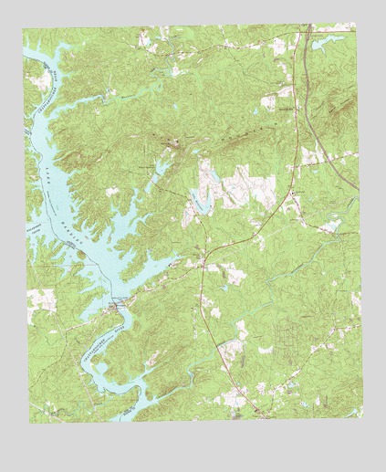
Bartletts Ferry Dam, GA USGS Topographic Map
Click on map above to begin viewing in our Map Viewer.

This topographic map contains these locations and features:
Feature Name Type Latitude Longitude GNIS ID View Map
Acton (historical)Populated PlaceN32.6529°W85.0099°350929View Map
AntiochPopulated PlaceN32.6776°W85.0583°350930View Map
Antioch Baptist ChurchChurchN32.6771°W85.0594°354341View Map
Antioch CemeteryCemeteryN32.6771°W85.0597°350931View Map
Antioch Volunteer Fire Department Station 1BuildingN32.6769°W85.0567°2603942View Map
Antioch Volunteer Fire Department Station 4BuildingN32.6978°W85.0254°2604459View Map
Barletts Ferry DamDamN32.6629°W85.0910°113479View Map
Bartletts Ferry (historical)CrossingN32.6632°W85.0910°350932View Map
Bartletts Ferry DamDamN32.6629°W85.0910°354474View Map
Bishop LakeReservoirN32.6468°W85.0433°340378View Map
Bishop Lake DamDamN32.6468°W85.0433°340377View Map
Blanton Ferry (historical)CrossingN32.7396°W85.1185°350941View Map
Brawner Ferry (historical)CrossingN32.6765°W85.0991°350944View Map
Camp LewisLocaleN32.6407°W85.0619°312235View Map
Camp Seven SpringsLocaleN32.7310°W85.0285°312253View Map
Clines CrossroadsPopulated PlaceN32.7474°W85.0210°350952View Map
Cooks IslandIslandN32.7015°W85.1124°350954View Map
Davis PondReservoirN32.7449°W85.0776°340761View Map
Davis Pond DamDamN32.7451°W85.0766°340760View Map
Day LakeReservoirN32.6258°W85.0471°338481View Map
Day Lake DamDamN32.6251°W85.0483°338480View Map
Dixon Ferry (historical)CrossingN32.7126°W85.1216°350957View Map
Double Pines ChurchChurchN32.7499°W85.0202°313581View Map
German MountainSummitN32.7221°W85.0088°331803View Map
Goat Rock LakeReservoirN32.6339°W85.0898°337190View Map
Halawakee CreekStreamN32.6887°W85.1169°157979View Map
Hargett Island (historical)IslandN32.7132°W85.1199°350969View Map
Hargett Mill (historical)LocaleN32.7404°W85.0688°350970View Map
Herrington IslandIslandN32.6835°W85.1024°350973View Map
Interchange 11CrossingN32.7474°W85.0177°350979View Map
Jackson Mill (historical)LocaleN32.6429°W85.0624°350981View Map
Jacksons Mill Covered Bridge (historical)BridgeN32.6432°W85.0624°350982View Map
Lake RebelLakeN32.6268°W85.0482°316564View Map
Lake Walter RichardsReservoirN32.7052°W85.0736°316570View Map
Lake Walter Richards DamDamN32.7046°W85.0758°338476View Map
Lake WilliamsReservoirN32.6925°W85.0596°316571View Map
Lake Williams DamDamN32.6915°W85.0560°338442View Map
Middle Huston LakeReservoirN32.7020°W85.0762°338485View Map
Middle Huston Lake DamDamN32.7001°W85.0766°338484View Map
Mill CreekStreamN32.6482°W85.1027°122792View Map
Mitchell BridgeBridgeN32.6826°W85.0083°350987View Map
Mountain HillPopulated PlaceN32.7232°W85.0227°356409View Map
Mountain Hill Baptist ChurchChurchN32.7235°W85.0222°350988View Map
Mountain Hill SchoolSchoolN32.6968°W85.0249°319075View Map
Mountain Oak CreekStreamN32.7212°W85.1163°319078View Map
Mulberry CreekStreamN32.6304°W85.0810°356413View Map
Old Smyrna CemeteryCemeteryN32.7474°W85.0146°2629402View Map
Osanippa CreekStreamN32.7162°W85.1224°154483View Map
Peterson LakeReservoirN32.7441°W85.0117°338475View Map
Peterson Lake DamDamN32.7435°W85.0166°338474View Map
Phipps Island (historical)IslandN32.6885°W85.1127°350997View Map
Piney GrovePopulated PlaceN32.6260°W85.0366°350999View Map
Piney Grove ChurchChurchN32.6254°W85.0360°320714View Map
Prospect ChurchChurchN32.6251°W85.0383°321163View Map
Riley LakeReservoirN32.7024°W85.0537°338491View Map
Riley Lake DamDamN32.7001°W85.0516°338490View Map
Sandy Point LandingLocaleN32.6526°W85.0994°138298View Map
South Huston LakeReservoirN32.6990°W85.0790°338493View Map
South Huston Lake DamDamN32.6968°W85.0799°338492View Map
Wacoochee CreekStreamN32.6346°W85.0985°153857View Map
Williams MountainSummitN32.7126°W85.0683°333433View Map

Note: Coordinates in the location and feature list above are referenced to NAD83 datum.


Copyright (C) 2008-2025 Ryan Niemi / Sunset Dynamics ... All Rights Reserved