TopoQuest Logo
Do you find TopoQuest useful?
Help keep TopoQuest running and adding new maps/features by donating!
Bitcoin:  19c7KJd3qBynnjoSw5npx9KScwjBe4ifkT
Litecoin:  LXs6TkuXGGXo1vDsWCkWVdjQX94eUKd6ui
Home View Maps Find Maps Find Places Resources & Links


Beulah, Alabama Topographic Map

USGS Map Title: Beulah, AL
USGS Map MRC: 32085F2
DRG (GeoTIFF) Download: o32085f2.tif


Neighboring USGS Topographic Map Quads:


  Cusseta, AL  
32085G3
 

  Lanett South, AL  
32085G2
 

  Whitesville, GA  
32085G1
 

  Opelika East, AL  
32085F3
 

  Beulah, AL  
32085F2
 

  Bartletts Ferry Dam, GA  
32085F1
 

  Parkers Crossroads, AL  
32085E3
 

  Bleecker, AL  
32085E2
 

  Smiths Station, AL  
32085E1


Map MRC Location:

N33°
W86°
N33°
W85°
H8 H7 H6 H5 H4 H3 H2 H1
G8 G7 G6 G5 G4 G3 G2 G1
F8 F7 F6 F5 F4 F3 F2 F1
E8 E7 E6 E5 E4 E3 E2 E1
D8 D7 D6 D5 D4 D3 D2 D1
C8 C7 C6 C5 C4 C3 C2 C1
B8 B7 B6 B5 B4 B3 B2 B1
A8 A7 A6 A5 A4 A3 A2 A1
N32°
W86°
N32°
W85°

Beulah, AL USGS 1:24K Topographic Map Preview:
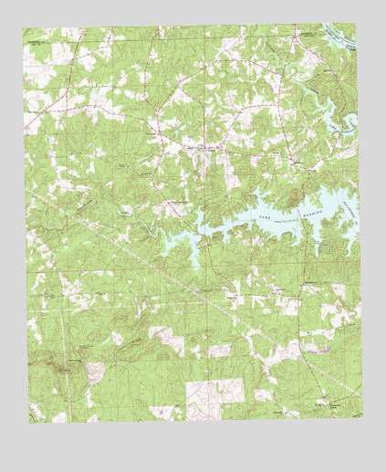
Beulah, AL USGS Topographic Map
Click on map above to begin viewing in our Map Viewer.

This topographic map contains these locations and features:
Feature Name Type Latitude Longitude GNIS ID View Map
Bartletts Ferry LakeReservoirN32.6861°W85.1327°1945742View Map
Berlin (historical)LocaleN32.7168°W85.1422°138113View Map
BeulahPopulated PlaceN32.7112°W85.1822°114173View Map
Beulah Baptist ChurchChurchN32.7118°W85.1761°138117View Map
Beulah CemeteryCemeteryN32.7129°W85.1749°138116View Map
Beulah DivisionCivilN32.6801°W85.2335°165848View Map
Beulah High SchoolSchoolN32.7104°W85.1830°138118View Map
Beulah United Methodist ChurchChurchN32.7118°W85.1827°152039View Map
Blands LandingLocaleN32.6815°W85.1391°156075View Map
BlantonPopulated PlaceN32.7346°W85.1338°114486View Map
Blanton ChurchChurchN32.7371°W85.1360°163465View Map
Burrell ChapelChurchN32.7062°W85.2122°115276View Map
County Line Baptist Church (historical)ChurchN32.6492°W85.2316°163659View Map
County Line Baptist Church CemeteryCemeteryN32.6492°W85.2313°2573601View Map
Dickinson Chapel Methodist Church (historical)ChurchN32.6682°W85.1391°138145View Map
Ebenezer ChurchChurchN32.6287°W85.1402°164047View Map
Flint Hill CemeteryCemeteryN32.6487°W85.1744°138167View Map
Flint Hill School (historical)SchoolN32.6493°W85.1736°138168View Map
Flint RidgeRidgeN32.6499°W85.2116°118433View Map
HalawakaPopulated PlaceN32.6646°W85.1713°156443View Map
Hattie (historical)LocaleN32.6632°W85.2355°163216View Map
Hephzibah CemeteryCemeteryN32.6862°W85.2497°163474View Map
Holt CemeteryCemeteryN32.7026°W85.2027°163475View Map
JesterPopulated PlaceN32.7035°W85.1436°156531View Map
John Calhoun Tillery CemeteryCemeteryN32.6937°W85.1941°138204View Map
John Vines Dunn Plantation (historical)LocaleN32.6335°W85.2277°138205View Map
Lamb CemeteryCemeteryN32.7093°W85.1930°138213View Map
Lee Chambers Fire Department Station 1BuildingN32.7109°W85.1796°2691391View Map
Lee Chambers Fire Department Station 2BuildingN32.7290°W85.2340°2691612View Map
Lee Chambers Fire Department Station 3BuildingN32.6696°W85.1461°2691333View Map
Lee Chambers Fire Department Station 4BuildingN32.6964°W85.1414°2691334View Map
Lee Chambers Fire Department Station 5BuildingN32.7109°W85.1786°2691261View Map
Living Water ChurchChurchN32.6643°W85.1699°163478View Map
McCullohPopulated PlaceN32.7065°W85.1497°156682View Map
Meadow Mill (historical)LocaleN32.6857°W85.2049°138226View Map
MechanicsvillePopulated PlaceN32.6668°W85.1469°156694View Map
Mechanicsville CemeteryCemeteryN32.6682°W85.1394°138228View Map
Milner (historical)LocaleN32.7279°W85.1463°163217View Map
Mountain Springs CemeteriesCemeteryN32.6485°W85.2310°152554View Map
Mountain Springs ChurchChurchN32.6446°W85.2294°164088View Map
Old Path ChurchChurchN32.7235°W85.2361°163480View Map
Pitts ChapelChurchN32.6654°W85.2416°152964View Map
Pitts Chapel CemeteryCemeteryN32.6651°W85.2416°138265View Map
Pleasant Hill ChurchChurchN32.7087°W85.1533°124997View Map
PowledgePopulated PlaceN32.6271°W85.1544°156928View Map
R E Newman DamDamN32.6451°W85.1399°130847View Map
R E Newman Number Two DamDamN32.6451°W85.1416°130848View Map
Rocky Mount Baptist ChurchChurchN32.6654°W85.1566°153203View Map
Rocky Mount CemeteryCemeteryN32.6651°W85.1560°138278View Map
Salem Lookout TowerTowerN32.6426°W85.2383°164410View Map
Tillery CrossroadPopulated PlaceN32.6937°W85.1961°157160View Map
Wacoochee ValleyPopulated PlaceN32.6296°W85.1383°164143View Map
Wacoochee Valley School (historical)SchoolN32.6410°W85.1441°138330View Map
Weeping Mary ChurchChurchN32.7032°W85.2066°128704View Map
Wells Bridge (historical)BridgeN32.6446°W85.1702°138337View Map
WSWS-TV (Opelika)TowerN32.6426°W85.2369°161254View Map
YarbroughPopulated PlaceN32.7160°W85.1991°157285View Map

Note: Coordinates in the location and feature list above are referenced to NAD83 datum.


Copyright (C) 2008-2025 Ryan Niemi / Sunset Dynamics ... All Rights Reserved