TopoQuest Logo
Do you find TopoQuest useful?
Help keep TopoQuest running and adding new maps/features by donating!
Bitcoin:  19c7KJd3qBynnjoSw5npx9KScwjBe4ifkT
Litecoin:  LXs6TkuXGGXo1vDsWCkWVdjQX94eUKd6ui
Home View Maps Find Maps Find Places Resources & Links


Leesburg, Indiana Topographic Map

USGS Map Title: Leesburg, IN
USGS Map MRC: 41085C7
DRG (GeoTIFF) Download: o41085c7.tif


Neighboring USGS Topographic Map Quads:


  Nappanee East, IN  
41085D8
 

  Milford, IN  
41085D7
 

  Lake Wawasee, IN  
41085D6
 

  Atwood, IN  
41085C8
 

  Leesburg, IN  
41085C7
 

  North Webster, IN  
41085C6
 

  Burket, IN  
41085B8
 

  Warsaw, IN  
41085B7
 

  Pierceton, IN  
41085B6


Map MRC Location:

N42°
W86°
N42°
W85°
H8 H7 H6 H5 H4 H3 H2 H1
G8 G7 G6 G5 G4 G3 G2 G1
F8 F7 F6 F5 F4 F3 F2 F1
E8 E7 E6 E5 E4 E3 E2 E1
D8 D7 D6 D5 D4 D3 D2 D1
C8 C7 C6 C5 C4 C3 C2 C1
B8 B7 B6 B5 B4 B3 B2 B1
A8 A7 A6 A5 A4 A3 A2 A1
N41°
W86°
N41°
W85°

Leesburg, IN USGS 1:24K Topographic Map Preview:
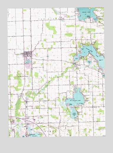
Leesburg, IN USGS Topographic Map
Click on map above to begin viewing in our Map Viewer.

This topographic map contains these locations and features:
Feature Name Type Latitude Longitude GNIS ID View Map
Arrowhead ParkPopulated PlaceN41.2789°W85.7900°430280View Map
Bell Rohr ParkPopulated PlaceN41.3317°W85.7811°430769View Map
Big Chapman LakeReservoirN41.2859°W85.7844°431022View Map
Cable RunStreamN41.3606°W85.7569°431934View Map
Deeds CreekStreamN41.2581°W85.8475°433407View Map
DeFries LandingPopulated PlaceN41.3659°W85.7680°433440View Map
Dewart LakeLakeN41.3698°W85.7733°433518View Map
Forest GlenPopulated PlaceN41.3267°W85.7636°434648View Map
Garber FieldAirportN41.3094°W85.7773°2717324View Map
Government PointCapeN41.3239°W85.7572°435247View Map
Groves CemeteryCemeteryN41.2511°W85.7966°435536View Map
Heeter DitchCanalN41.2625°W85.8005°435980View Map
Hickman DitchCanalN41.2670°W85.8383°436092View Map
Highlands ParkPopulated PlaceN41.2734°W85.7858°436174View Map
Island ParkPopulated PlaceN41.2870°W85.8003°436853View Map
Kalorama ParkPopulated PlaceN41.3345°W85.7608°437157View Map
Kohler DitchCanalN41.3353°W85.8475°437422View Map
Lakeside ParkPopulated PlaceN41.2523°W85.8492°437554View Map
LeesburgPopulated PlaceN41.3320°W85.8500°449682View Map
Leesburg Elementary SchoolSchoolN41.3292°W85.8500°447467View Map
Little Chapman LakeSwampN41.2832°W85.7884°452460View Map
Little Pike LakeLakeN41.2578°W85.8489°438114View Map
Lones DitchCanalN41.2631°W85.8558°438241View Map
Long DitchCanalN41.3173°W85.7758°438263View Map
McElroy HillSummitN41.2662°W85.8711°438858View Map
MonoquetPopulated PlaceN41.2895°W85.8617°439337View Map
Musquabuck ParkPopulated PlaceN41.3687°W85.7814°439904View Map
New Salem ChurchChurchN41.3634°W85.8061°440113View Map
Old Channel Kankakee RiverChannelN41.2745°W85.8705°440551View Map
Osborn LandingPopulated PlaceN41.2812°W85.7969°440714View Map
OswegoPopulated PlaceN41.3203°W85.7872°440727View Map
Oswego LakeReservoirN41.3264°W85.7861°440728View Map
Otis R Bowen Center for Human Services Intake CenterBuildingN41.2518°W85.8311°2660536View Map
Patona BayReservoirN41.3345°W85.7797°440924View Map
Pike LakeLakeN41.2516°W85.8434°441135View Map
Plain Township Leesburg Volunteer Fire DepartmentBuildingN41.3267°W85.8435°2626425View Map
Potawatomi ParkPopulated PlaceN41.3234°W85.7586°441498View Map
Quaker Haven ParkPopulated PlaceN41.3670°W85.7605°441686View Map
Ruple DitchCanalN41.3062°W85.7828°442392View Map
Silver PointPopulated PlaceN41.3314°W85.7689°449843View Map
Stanton LakeLakeN41.3220°W85.7700°444066View Map
Stoneburner LandingPopulated PlaceN41.2850°W85.7767°444214View Map
Stony RidgePopulated PlaceN41.3273°W85.7769°444232View Map
Tippecanoe Country ClubLocaleN41.3409°W85.7625°452405View Map
Tippecanoe LakeLakeN41.3273°W85.7629°444781View Map
Town of LeesburgCivilN41.3307°W85.8489°2396712View Map
Township of PlainCivilN41.3060°W85.8250°453743View Map
Wa-Will-Away ParkPopulated PlaceN41.2900°W85.7780°445326View Map
Walker ParkPopulated PlaceN41.3295°W85.7533°445380View Map
Warsaw Municipal AirportAirportN41.2783°W85.8455°449376View Map
Westlake DitchCanalN41.3595°W85.7536°445836View Map

Note: Coordinates in the location and feature list above are referenced to NAD83 datum.


Copyright (C) 2008-2025 Ryan Niemi / Sunset Dynamics ... All Rights Reserved