TopoQuest Logo
Do you find TopoQuest useful?
Help keep TopoQuest running and adding new maps/features by donating!
Bitcoin:  19c7KJd3qBynnjoSw5npx9KScwjBe4ifkT
Litecoin:  LXs6TkuXGGXo1vDsWCkWVdjQX94eUKd6ui
Home View Maps Find Maps Find Places Resources & Links


Milford, Indiana Topographic Map

USGS Map Title: Milford, IN
USGS Map MRC: 41085D7
DRG (GeoTIFF) Download: o41085d7.tif


Neighboring USGS Topographic Map Quads:


  Foraker, IN  
41085E8
 

  Goshen, IN  
41085E7
 

  Millersburg, IN  
41085E6
 

  Nappanee East, IN  
41085D8
 

  Milford, IN  
41085D7
 

  Lake Wawasee, IN  
41085D6
 

  Atwood, IN  
41085C8
 

  Leesburg, IN  
41085C7
 

  North Webster, IN  
41085C6


Map MRC Location:

N42°
W86°
N42°
W85°
H8 H7 H6 H5 H4 H3 H2 H1
G8 G7 G6 G5 G4 G3 G2 G1
F8 F7 F6 F5 F4 F3 F2 F1
E8 E7 E6 E5 E4 E3 E2 E1
D8 D7 D6 D5 D4 D3 D2 D1
C8 C7 C6 C5 C4 C3 C2 C1
B8 B7 B6 B5 B4 B3 B2 B1
A8 A7 A6 A5 A4 A3 A2 A1
N41°
W86°
N41°
W85°

Milford, IN USGS 1:24K Topographic Map Preview:
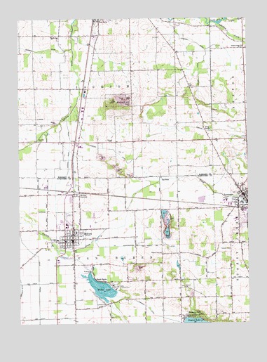
Milford, IN USGS Topographic Map
Click on map above to begin viewing in our Map Viewer.

This topographic map contains these locations and features:
Feature Name Type Latitude Longitude GNIS ID View Map
Bethany SchoolSchoolN41.4498°W85.8244°430878View Map
Buzzard HillSummitN41.4653°W85.8186°431917View Map
Camp Alexander MackParkN41.3900°W85.8219°432006View Map
Concord ChurchChurchN41.3898°W85.7850°432865View Map
Coppes DitchCanalN41.3856°W85.8661°432957View Map
Dry RunStreamN41.4909°W85.7608°433731View Map
Frog PondLakeN41.4545°W85.7701°434879View Map
H R Weisser AirportAirportN41.4234°W85.8470°449266View Map
Hammond DitchCanalN41.3781°W85.8005°435659View Map
Hoopingarner DitchCanalN41.4095°W85.8011°436411View Map
Jackson Township Emergency Ambulance ServiceBuildingN41.4936°W85.8322°2719278View Map
Kieffer DitchCanalN41.4409°W85.8147°437287View Map
Lakeside CemeteryCemeteryN41.3831°W85.8269°437550View Map
Maple Grove ChurchChurchN41.4928°W85.8569°438560View Map
Matthews FarmsLocaleN41.4836°W85.8319°2708030View Map
MilfordPopulated PlaceN41.4098°W85.8455°439139View Map
Milford CemeteryCemeteryN41.4214°W85.8625°439140View Map
Milford Elementary SchoolSchoolN41.4092°W85.8544°447475View Map
Milford JunctionPopulated PlaceN41.4284°W85.8419°439141View Map
Milford Junior High SchoolSchoolN41.4092°W85.8544°447474View Map
Milford Police DepartmentBuildingN41.4090°W85.8464°2758043View Map
Milford Volunteer Fire DepartmentBuildingN41.4075°W85.8456°2626387View Map
Multiple Township Emergency Medical Services - MilfordBuildingN41.4092°W85.8464°2719305View Map
New Paris Fire DepartmentBuildingN41.4936°W85.8322°2625741View Map
Pleasant View CemeteryCemeteryN41.4039°W85.7967°441339View Map
Preston Miles DitchCanalN41.4331°W85.8528°441579View Map
Redmon ParkPopulated PlaceN41.3781°W85.7794°441838View Map
Shady BanksPopulated PlaceN41.3923°W85.8303°443244View Map
Skinner DitchCanalN41.4131°W85.7503°443582View Map
Snider FarmsLocaleN41.4633°W85.8664°2628452View Map
Solomon Creek ChurchChurchN41.4878°W85.7525°443758View Map
SyracusePopulated PlaceN41.4278°W85.7525°444529View Map
Syracuse Elementary SchoolSchoolN41.4242°W85.7525°447473View Map
Syracuse Fire Department Station 1BuildingN41.4254°W85.7501°2625593View Map
Syracuse Junior High SchoolSchoolN41.4242°W85.7525°447472View Map
Syracuse Post Office (historical)Post OfficeN41.4278°W85.7525°2027052View Map
Tamarack CemeteryCemeteryN41.4053°W85.7600°444557View Map
Town of MilfordCivilN41.4143°W85.8447°2396763View Map
Township of JacksonCivilN41.4788°W85.8276°453442View Map
Township of Van BurenCivilN41.3920°W85.8270°453947View Map
WAKE-AM (Valparaiso)TowerN41.4434°W85.8219°448412View Map
Waubee LakeLakeN41.3896°W85.8307°445335View Map
Wawasee High SchoolSchoolN41.4181°W85.7569°447471View Map
Whetten DitchCanalN41.4920°W85.7864°445899View Map
Worley DitchCanalN41.4781°W85.7764°446329View Map
Zimmerman Gravel PitMineN41.3972°W85.8092°2649822View Map

Note: Coordinates in the location and feature list above are referenced to NAD83 datum.


Copyright (C) 2008-2024 Ryan Niemi / Sunset Dynamics ... All Rights Reserved