TopoQuest Logo
Do you find TopoQuest useful?
Help keep TopoQuest running and adding new maps/features by donating!
Bitcoin:  19c7KJd3qBynnjoSw5npx9KScwjBe4ifkT
Litecoin:  LXs6TkuXGGXo1vDsWCkWVdjQX94eUKd6ui
Home View Maps Find Maps Find Places Resources & Links


Water Canyon, New Mexico Topographic Map

USGS Map Title: Water Canyon, NM
USGS Map MRC: 34107A1
DRG (GeoTIFF) Download: o34107a1.tif


Neighboring USGS Topographic Map Quads:


  Granite Mountain, NM  
34107B2
 

  San Lorenzo Spring, NM  
34107B1
 

  Lemitar, NM  
34106B8
 

  Magdalena, NM  
34107A2
 

  Water Canyon, NM  
34107A1
 

  Socorro, NM  
34106A8
 

  South Baldy, NM  
33107H2
 

  Molino Peak, NM  
33107H1
 

  Luis Lopez, NM  
33106H8


Map MRC Location:

N35°
W108°
N35°
W107°
H8 H7 H6 H5 H4 H3 H2 H1
G8 G7 G6 G5 G4 G3 G2 G1
F8 F7 F6 F5 F4 F3 F2 F1
E8 E7 E6 E5 E4 E3 E2 E1
D8 D7 D6 D5 D4 D3 D2 D1
C8 C7 C6 C5 C4 C3 C2 C1
B8 B7 B6 B5 B4 B3 B2 B1
A8 A7 A6 A5 A4 A3 A2 A1
N34°
W108°
N34°
W107°

Water Canyon, NM USGS 1:24K Topographic Map Preview:
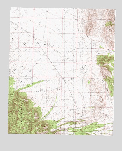
Water Canyon, NM USGS Topographic Map
Click on map above to begin viewing in our Map Viewer.

This topographic map contains these locations and features:
Feature Name Type Latitude Longitude GNIS ID View Map
A Strozzi RanchLocaleN34.1220°W107.1053°902927View Map
B Kelly RanchLocaleN34.1203°W107.0798°903474View Map
Combs and Wood ClaimsMineN34.0062°W107.0839°916538View Map
Garcia CanyonValleyN34.1017°W107.0961°906472View Map
Jordan CanyonValleyN34.1090°W107.1145°907438View Map
Kelly RanchLocaleN34.0309°W107.1242°907528View Map
Kelly Ranch Weather StationLocaleN34.0309°W107.1242°931853View Map
Negrohead Property MineMineN34.0084°W107.0623°936853View Map
Sedillo Hill ReservoirReservoirN34.0249°W107.0454°910921View Map
Shakespeare CanyonValleyN34.0726°W107.1034°910971View Map
Snake RanchLocaleN34.0909°W107.0214°911166View Map
Snake Ranch SpringSpringN34.0917°W107.0192°914371View Map
South CanyonValleyN34.0773°W107.0214°911219View Map
Strawberry PeakSummitN34.1056°W107.0053°911450View Map
Water CanyonValleyN34.0842°W107.0056°912181View Map
Water CanyonLocaleN34.0884°W107.0798°923716View Map
Water Canyon Forest Service FacilityLocaleN34.0370°W107.1203°914198View Map
Water Canyon LodgeLocaleN34.0615°W107.0656°912183View Map
Water Canyon MesaSummitN34.0151°W107.1245°914180View Map
Water Canyon Post Office (historical)Post OfficeN34.0884°W107.0798°937689View Map
West Negrohead MineMineN34.0117°W107.0839°936854View Map
Wet Weather SpringSpringN34.0290°W107.1011°914199View Map

Note: Coordinates in the location and feature list above are referenced to NAD83 datum.


Copyright (C) 2008-2025 Ryan Niemi / Sunset Dynamics ... All Rights Reserved