TopoQuest Logo
Do you find TopoQuest useful?
Help keep TopoQuest running and adding new maps/features by donating!
Bitcoin:  19c7KJd3qBynnjoSw5npx9KScwjBe4ifkT
Litecoin:  LXs6TkuXGGXo1vDsWCkWVdjQX94eUKd6ui
Home View Maps Find Maps Find Places Resources & Links


Bashi, Alabama Topographic Map

USGS Map Title: Bashi, AL
USGS Map MRC: 31087H7
DRG (GeoTIFF) Download: o31087h7.tif


Neighboring USGS Topographic Map Quads:


  Nanafalia, AL  
32087A8
 

  Sweet Water, AL  
32087A7
 

  Surginer, AL  
32087A6
 

  Morvin, AL  
31087H8
 

  Bashi, AL  
31087H7
 

  Thomasville, AL  
31087H6
 

  McEntyre, AL  
31087G8
 

  Fulton West, AL  
31087G7
 

  Fulton East, AL  
31087G6


Map MRC Location:

N32°
W88°
N32°
W87°
H8 H7 H6 H5 H4 H3 H2 H1
G8 G7 G6 G5 G4 G3 G2 G1
F8 F7 F6 F5 F4 F3 F2 F1
E8 E7 E6 E5 E4 E3 E2 E1
D8 D7 D6 D5 D4 D3 D2 D1
C8 C7 C6 C5 C4 C3 C2 C1
B8 B7 B6 B5 B4 B3 B2 B1
A8 A7 A6 A5 A4 A3 A2 A1
N31°
W88°
N31°
W87°

Bashi, AL USGS 1:24K Topographic Map Preview:
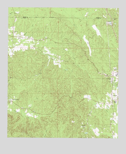
Bashi, AL USGS Topographic Map
Click on map above to begin viewing in our Map Viewer.

This topographic map contains these locations and features:
Feature Name Type Latitude Longitude GNIS ID View Map
BashiPopulated PlaceN31.9713°W87.8614°113543View Map
Bashi AcademySchoolN31.9707°W87.8586°133578View Map
Bashi CemeteryCemeteryN31.9699°W87.8586°1730350View Map
Bashi United Methodist ChurchChurchN31.9704°W87.8586°133579View Map
Bethel CemeteryCemeteryN31.9896°W87.7558°114015View Map
Bethel Methodist Church (historical)ChurchN31.9888°W87.7564°133583View Map
Carlstons Mill (historical)LocaleN31.9252°W87.7542°133593View Map
Choctaw CornerPopulated PlaceN31.9349°W87.7547°133598View Map
Choctaw Corner CemeteryCemeteryN31.9321°W87.7578°116079View Map
Dick Mill CreekStreamN31.9046°W87.8703°133612View Map
Elam CemeteryCemeteryN31.9326°W87.8728°1730208View Map
Elam ChurchChurchN31.9324°W87.8728°133619View Map
Elam Methodist ChurchChurchN31.9265°W87.8747°133620View Map
GloverPopulated PlaceN31.9371°W87.8400°156410View Map
Indian CreekStreamN31.8963°W87.8572°120635View Map
J D Phillips LakeReservoirN31.8799°W87.7858°130004View Map
J D Phillips Lake DamDamN31.8802°W87.7850°130003View Map
Johnson CreekStreamN31.9590°W87.8386°133657View Map
McFadden Memorial GardensCemeteryN31.9113°W87.7525°122538View Map
Messiah ChurchChurchN31.9702°W87.8339°122672View Map
MidwayPopulated PlaceN31.8857°W87.7889°156706View Map
Midway ChurchChurchN31.8863°W87.7875°133673View Map
Miles ChapelChurchN31.9352°W87.7622°122724View Map
New Hope Number 1 Baptist ChurchChurchN31.9299°W87.7575°152635View Map
Thomasville AcademySchoolN31.9418°W87.7533°127882View Map
Thomasville Air Force Station (historical)MilitaryN31.9372°W87.7519°2090213View Map
Thomasville DivisionCivilN31.8915°W87.8522°161604View Map

Note: Coordinates in the location and feature list above are referenced to NAD83 datum.


Copyright (C) 2008-2025 Ryan Niemi / Sunset Dynamics ... All Rights Reserved