TopoQuest Logo
Do you find TopoQuest useful?
Help keep TopoQuest running and adding new maps/features by donating!
Bitcoin:  19c7KJd3qBynnjoSw5npx9KScwjBe4ifkT
Litecoin:  LXs6TkuXGGXo1vDsWCkWVdjQX94eUKd6ui
Home View Maps Find Maps Find Places Resources & Links


Surginer, Alabama Topographic Map

USGS Map Title: Surginer, AL
USGS Map MRC: 32087A6
DRG (GeoTIFF) Download: o32087a6.tif


Neighboring USGS Topographic Map Quads:


  Miller, AL  
32087B7
 

  Magnolia, AL  
32087B6
 

  Flatwood, AL  
32087B5
 

  Sweet Water, AL  
32087A7
 

  Surginer, AL  
32087A6
 

  Kimbrough, AL  
32087A5
 

  Bashi, AL  
31087H7
 

  Thomasville, AL  
31087H6
 

  Pine Hill, AL  
31087H5


Map MRC Location:

N33°
W88°
N33°
W87°
H8 H7 H6 H5 H4 H3 H2 H1
G8 G7 G6 G5 G4 G3 G2 G1
F8 F7 F6 F5 F4 F3 F2 F1
E8 E7 E6 E5 E4 E3 E2 E1
D8 D7 D6 D5 D4 D3 D2 D1
C8 C7 C6 C5 C4 C3 C2 C1
B8 B7 B6 B5 B4 B3 B2 B1
A8 A7 A6 A5 A4 A3 A2 A1
N32°
W88°
N32°
W87°

Surginer, AL USGS 1:24K Topographic Map Preview:
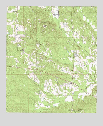
Surginer, AL USGS Topographic Map
Click on map above to begin viewing in our Map Viewer.

This topographic map contains these locations and features:
Feature Name Type Latitude Longitude GNIS ID View Map
Arbor CemeteryCemeteryN32.0279°W87.7050°113196View Map
Arbor Church (historical)ChurchN32.0288°W87.7050°137563View Map
Baptizing CreekStreamN32.0382°W87.6286°113458View Map
Christian Hope CemeteryCemeteryN32.1151°W87.6731°1867903View Map
Christian Hope ChurchChurchN32.1157°W87.6747°116097View Map
Christian Union ChurchChurchN32.0246°W87.7456°116102View Map
Church of GodChurchN32.0632°W87.7206°155031View Map
Church of GodChurchN32.1057°W87.6981°155032View Map
Church of GodChurchN32.1068°W87.7056°155033View Map
Cypress CreekStreamN32.0585°W87.6661°137592View Map
Dixons Mill DivisionCivilN32.0593°W87.7269°165873View Map
Dry CreekStreamN32.0354°W87.6269°117532View Map
Ellison (historical)Populated PlaceN32.0332°W87.7125°1730246View Map
Friendship Baptist ChurchChurchN32.0493°W87.6519°151780View Map
Friendship Baptist Church CemeteryCemeteryN32.0501°W87.6514°1867950View Map
HampdenPopulated PlaceN32.0815°W87.6289°156449View Map
Holy ChurchChurchN32.1026°W87.6981°120306View Map
Hosea CemeteryCemeteryN32.0910°W87.7358°120449View Map
Jackson School (historical)SchoolN32.0429°W87.6417°163201View Map
Laurel Presbyterian CemeteryCemeteryN32.1146°W87.7372°121420View Map
Little CreekStreamN32.0271°W87.6425°121752View Map
Living CemeteryCemeteryN32.1065°W87.7044°1867898View Map
Magnolia TerminalLocaleN32.1151°W87.6800°122219View Map
Moores ValleyPopulated PlaceN32.0610°W87.6300°156734View Map
Piney Woods CreekStreamN32.0165°W87.6764°155205View Map
Pope School (historical)SchoolN32.0610°W87.6867°137654View Map
Pritchett Mill CreekStreamN32.0660°W87.6883°163203View Map
Pritchett School (historical)SchoolN32.0671°W87.6564°137656View Map
Shields School (historical)SchoolN32.1001°W87.6642°137670View Map
Shiloh Lookout TowerTowerN32.1190°W87.7361°164417View Map
Shop CemeteryCemeteryN32.0868°W87.7156°126802View Map
SurginerPopulated PlaceN32.0554°W87.7092°155266View Map
Surginer Volunteer Fire Department Station 1BuildingN32.0700°W87.7238°2691580View Map
Threadgill Mill CreekStreamN32.0868°W87.7081°137674View Map
Turkey CreekStreamN32.0043°W87.7006°128156View Map
Union Baptist ChurchChurchN32.0465°W87.6525°153762View Map
Union CemeteryCemeteryN32.0457°W87.6511°1867924View Map
Union Grove ChurchChurchN32.0549°W87.7086°128314View Map
VinelandPopulated PlaceN32.0357°W87.6594°128461View Map
Vineland ChurchChurchN32.0349°W87.6650°137678View Map
Vineland Macedonia ChurchChurchN32.0743°W87.6675°154776View Map
Wesley Chapel CemeteryCemeteryN32.0729°W87.7272°1805470View Map
Wesley Chapel Elementary School (historical)SchoolN32.0721°W87.7258°151620View Map
Wesley Chapel United Methodist ChurchChurchN32.0738°W87.7275°128741View Map
Wilma School (historical)SchoolN32.0076°W87.6375°137681View Map

Note: Coordinates in the location and feature list above are referenced to NAD83 datum.


Copyright (C) 2008-2025 Ryan Niemi / Sunset Dynamics ... All Rights Reserved