TopoQuest Logo
Do you find TopoQuest useful?
Help keep TopoQuest running and adding new maps/features by donating!
Bitcoin:  19c7KJd3qBynnjoSw5npx9KScwjBe4ifkT
Litecoin:  LXs6TkuXGGXo1vDsWCkWVdjQX94eUKd6ui
Home View Maps Find Maps Find Places Resources & Links


Nanafalia, Alabama Topographic Map

USGS Map Title: Nanafalia, AL
USGS Map MRC: 32087A8
DRG (GeoTIFF) Download: o32087a8.tif


Neighboring USGS Topographic Map Quads:


  Pennington, AL  
32088B1
 

  Myrtlewood South, AL  
32087B8
 

  Miller, AL  
32087B7
 

  Putnam, AL  
32088A1
 

  Nanafalia, AL  
32087A8
 

  Sweet Water, AL  
32087A7
 

  Woods Bluff, AL  
31088H1
 

  Morvin, AL  
31087H8
 

  Bashi, AL  
31087H7


Map MRC Location:

N33°
W88°
N33°
W87°
H8 H7 H6 H5 H4 H3 H2 H1
G8 G7 G6 G5 G4 G3 G2 G1
F8 F7 F6 F5 F4 F3 F2 F1
E8 E7 E6 E5 E4 E3 E2 E1
D8 D7 D6 D5 D4 D3 D2 D1
C8 C7 C6 C5 C4 C3 C2 C1
B8 B7 B6 B5 B4 B3 B2 B1
A8 A7 A6 A5 A4 A3 A2 A1
N32°
W88°
N32°
W87°

Nanafalia, AL USGS 1:24K Topographic Map Preview:
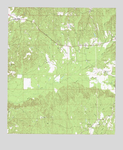
Nanafalia, AL USGS Topographic Map
Click on map above to begin viewing in our Map Viewer.

This topographic map contains these locations and features:
Feature Name Type Latitude Longitude GNIS ID View Map
AimwellPopulated PlaceN32.1215°W87.9061°112946View Map
Aimwell Baptist ChurchChurchN32.1240°W87.9033°137560View Map
Aimwell CemeteryCemeteryN32.1238°W87.9028°1867936View Map
Antioch CemeteryCemeteryN32.0143°W87.8942°1867897View Map
Antioch ChurchChurchN32.0146°W87.8939°113137View Map
Cox SchoolSchoolN32.0879°W87.9103°154149View Map
CoxheathPopulated PlaceN32.0879°W87.9103°116796View Map
Gibson CemeteryCemeteryN32.0218°W87.9989°118925View Map
Hickory Grove CemeteryCemeteryN32.0682°W87.9972°120024View Map
Hickory Grove ChapelChurchN32.0688°W87.9972°137612View Map
HobokenPopulated PlaceN32.0260°W87.8770°120165View Map
Hoboken Baptist ChurchChurchN32.0296°W87.8767°154150View Map
Hoboken CemeteryCemeteryN32.0304°W87.8764°1730250View Map
Hodgens CreekStreamN32.0774°W87.8945°120171View Map
Holiness ChurchChurchN32.0851°W87.9406°120229View Map
Independent Baptist ChurchChurchN32.0732°W87.9095°151849View Map
Indian BranchStreamN32.0102°W87.8964°120627View Map
LascaPopulated PlaceN32.0165°W87.9583°121403View Map
Luker CemeteryCemeteryN32.0104°W87.9539°122106View Map
Mill CreekStreamN32.0629°W87.9167°122787View Map
NanafaliaPopulated PlaceN32.1129°W87.9881°123631View Map
Nanafalia Baptist CemeteryCemeteryN32.1138°W87.9878°1730399View Map
Nanafalia Baptist ChurchChurchN32.1132°W87.9870°151585View Map
Nanafalia Census Designated PlaceCensusN32.1114°W87.9958°2628600View Map
Nanafalia Post OfficePost OfficeN32.1132°W87.9862°2789056View Map
Nichols CreekStreamN32.0513°W87.9470°123940View Map
NicholsvillePopulated PlaceN32.0082°W87.9020°123945View Map
Nicholsville Baptist ChurchChurchN32.0077°W87.9022°154152View Map
Old Liberty CemeteryCemeteryN32.0104°W87.8914°124218View Map
Old Union Baptist ChurchChurchN32.0618°W87.8872°124267View Map
Old Union CemeteryCemeteryN32.0613°W87.8867°1867935View Map
Pill Berry CreekStreamN32.0663°W87.9408°124747View Map
Saint Paul CemeteryCemeteryN32.0707°W87.9570°126174View Map
Saint Paul ChurchChurchN32.0671°W87.9631°126177View Map
South Marengo Fire and Rescue SquadBuildingN32.0868°W87.9257°2691590View Map
South Marengo Fire and Rescue Squad Aimwell StationBuildingN32.1226°W87.9050°2691595View Map
South Marengo Fire and Rescue Squad Nanafalia StationBuildingN32.1124°W87.9864°2691594View Map
Sweet Water DivisionCivilN32.0801°W87.9448°165875View Map
Sweetwater CreekStreamN32.0557°W87.9281°127594View Map

Note: Coordinates in the location and feature list above are referenced to NAD83 datum.


Copyright (C) 2008-2025 Ryan Niemi / Sunset Dynamics ... All Rights Reserved